Multi-Day Winter Weather Event Kicks Off Meteorological Winter

11:30 am – Snow and mixed precipitation has begun to fall across the NYC Tri-State Area as a two-day winter storm moves into the Northeast. December 1 is considered the first day of ‘Meteorological Winter’ – a period of time that lasts until the end of February and is considered the coldest three month period in the Northern Hemisphere.

THE FREEZING LINE

This storm will be characterized by sharp precipitation boundaries over relatively short distances. The difference between coastal and inland locations, or even changes in elevation of only several hundred feet, will dictate both when and how much frozen precipitation will fall and accumulate.

  • INLAND LOCATIONS (Or above 400 ft elevation) – Winter Storm Warnings. The most inland locations will likely not experience any mixed precipitation at all. Snow accumulations in these areas may exceed one foot. For less inland locations currently under a winter storm warning, a mid-afternoon changeover to mixed precipitation or rain is expected today, with a refreeze and changeover back to snow expected around noon Monday. Among the several inches of snow possible, the threat exists for ice to accumulate on roadways, trees, and power lines. Travel will be significantly more difficult during periods of heavier precipitation this afternoon and evening. A refreeze as well as more snow tomorrow will further complicate travel. Exercise extreme caution on roadways and avoid unnecessary travel if possible.
  • COASTAL LOCATIONS (Generally less than 400 ft elevation) – Winter Weather Advisories or no winter weather alert. A mix of snow, sleet, freezing rain, and rain will transition to all rain by mid-afternoon today. A transition back to frozen precipitation is expected Monday afternoon. Several inches of snow as well as some ice accumulation are possible. Exercise caution on slick roadways.

Due to the mixed-precipitation nature of this early December storm, any actual snow accumulation will depend on how long snow falls before transitioning to sleet, freezing rain, or rain. Total storm accumulations will likely be impacted by any changeover to rain.

Conditions may vary significantly over relatively short distances. Be prepared for rapidly changing conditions and exercise caution while outdoors and on the road.

First Accumulating Snow of Season Expected Thursday

A developing nor’easter is promising to bring the season’s first significant snowfall to the NYC tri-state area later this week.
This is the first Weather 360 forecast made with the aid of a new forecasting algorithm tailored to the NYC Metro Area. Updated as of 8 pm ET Tuesday, November 13, 2018.
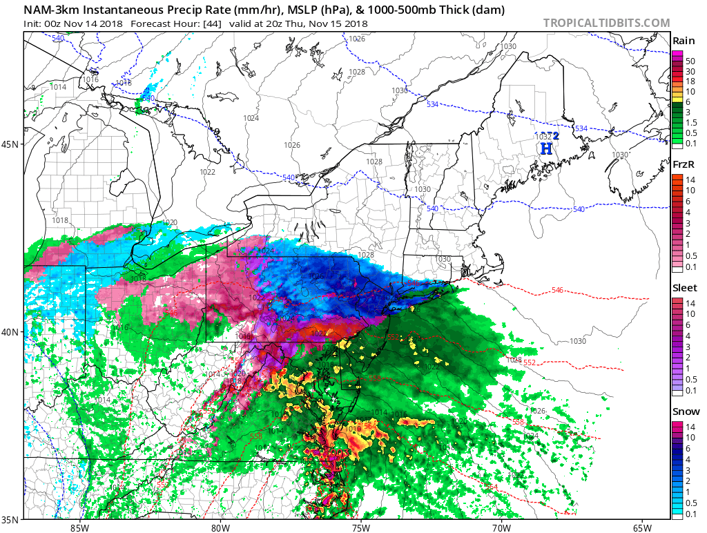
The heaviest snowfall will likely be around or after sunset Thursday with the potential for some light icing around midnight. Though while the storm system may bring upwards of half a foot of snow or more to some locations by late Thursday night or early Friday morning, due to the warm air brought by the proximity of the center of the storm to the coast, come the morning commute on Friday most of it will be more slush than snow.
The potential for heavy snow to develop quickly Thursday afternoon over the NYC Metro Area. 
As with most winter weather events this early in the season, slight changes in track can mean the difference between freezing and above freezing and rain and snow. However, due to the possibility for snow to accumulate within minutes on some surfaces, travel may become hazardous from mid-afternoon Thursday through late morning Friday.

Largest Winter Storm of Season Takes Aim at NYC Tri-State

The National Weather Service has issued Winter Storm Warnings for locations across New York, New Jersey, and Connecticut. Snow showers earlier this morning left 1-3 inches of snow on grassy surfaces across the area, but the brunt of the storm is only now beginning to move over Long Island and New Jersey. Heavy bands of snow developing this morning will intensify throughout the afternoon, bringing with them snowfall rates upwards of 2 inches per hour and wind gusts of 30-40 mph.

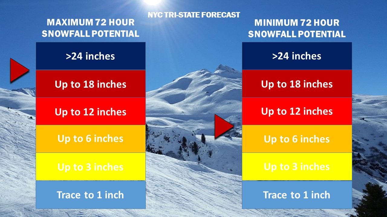
Snow Accumulation 18-3
Weather 360 NYC Tri-State 72 Hour Snowfall Forecast as of 9:30 AM today.

While snow totals to the east of the city in Long Island will likely remain at or below the one foot mark, locations to the west, northwest, and north of the city have the potential to reach over 18 inches of snow by Thursday morning.

Due to high winds combined with heavy snow this afternoon, it is advised that all unnecessary travel is avoided until the storm subsides tomorrow.

Severe Weather Outbreak and Tornado Warnings

ALERT: The National Weather Service in Albany, New York has issued a TORNADO WARNING in effect until 4:30 PM Eastern Standard Time.  The National Weather Service is also maintaining a TORNADO WATCH for the entire NYC Metro Area until 10:00 PM EST July 1, 2016.  Heed all warnings set out by the National Weather Service and take all necessary common sense precautions.

This evening into tonight, several rounds of potentially severe thunderstorms are expected to move through the NYC Metro Area, bringing with them damaging winds, hail, lightning, and torrential rains.  The first round of storms has already produced several severe thunderstorms and one storm capable of producing a tornado. Please be advised that in order to receive up-to-date weather alerts and warnings, one will have to consult the National Weather Service via Weather Radio or online.  Weather360 estimates there is a 66% chance for Severe Weather Development to continue throughout the NYC Metro Area going into tonight.

These storms are expected to continue for up to several hours, creating the possibility for widespread power outages and downed trees and tree limbs.

For more information, please consult the National Weather Service while we here at Weather360 will continue to inform you of upcoming threats via our YouTube Channel or right here at Weather360.net.


First Snowfall in and around New York City!

The unofficial start winter was today across many locations north and west of NYC.  Although no measurable snowfall was recorded, locations from in and around Poughkeepsie to as far south as Salem, Peekskill, and even some locations in western Connecticut, experienced flurries and light snow showers a good one to two months ahead of time.

Why the snow?

Although temperatures in and around the NYC Metro Area were generally higher than freezing at the time of the snow, the temperature in the atmosphere was a bit cooler than freezing, which allowed fast-falling snow to reach the ground before it melted in-air.

Due to the above freezing temperatures of the ground though, many of these snowflakes melted within 30 seconds of contact with the ground.

(The official start of Meteorological Winter is December 1st, and the start of the season Winter is generally considered December 21st.)

Hurricane Joaquin is a Category Four Storm, Track Uncertainty Remains

As of October 1 2015 12:00 PM Atlantic Standard Time (EDT)

Hurricane Hunter Aircraft flying at low altitudes has recovered wind speeds upwards of 115 Knots (About 130 MPH), and the storm now has a Mean Sea-level Pressure (MSLP) of 939 millibars. Joaquin is still moving southwest into The Bahamas, but is expected to reach the Jet Stream shortly and begin its turn to the north.  At this moment, one on a satellite image may view this change in direction, as it has just begun.  As this has just begun, the storm is still moving to the west, so the storm will likely stay on the slightly westward side of the current NHC Track Cone issued at the 11 AM 15 Advisory Update.  At the moment many of the computer models seem to be incorrect in saying it would temporarily stall out in The Bahamas and sling-shotting to the northeast, for the storm has started to move slightly to the northwest.

Locations across the East Coast that need to be on alert are: North Carolina, Virginia, Maryland, Delaware, New Jersey, New York, Connecticut, Rhode Island, and Maine.

More updates soon here on Weather360.

For emergency information, consult the NHC at http://www.nhc.noaa.gov

TROPICAL STORM JOAQUIN TO STRENGTHEN AND IMPACT THE EAST COAST

Overnight:  Hurricane Warnings and Watches has been issued for The Bahamas, as Tropical Storm Joaquin is expected to strengthen to a hurricane shortly and impact The Bahamas over the next two to three days.  The NHC track has also shifted to the west, with a track that has Hurricane Joaquin impacting The East Coast anywhere from New Jersey to Rhode Island this coming Monday or Tuesday.

Everyone from Virginia to Rhode Island should continue to monitor this storm and be prepared for every scenario for your area.  Now is the time to make sure you have what you need in the event a hurricane impacts you.

The Models:

The current most popular trend with some of the more major, long range computer models, all try to bring this storm into  locations just south of Delaware, but other major computer models such as the ECMWF and the TVCN (The most popular among the NHC) suggest a more easterly track, which will likely shift the current general trend back up to the north and east once more, but yet again, we can not predict this with 100% accuracy, for this storm has been rapidly strengthening so much, every single computer model seems to shift in every which direction  every model run…

We’ll continue to monitor the storm for you – Weather360 9/30/15

Tropical Storm Joaquin Expected to Strengthen and May Impact East Coast

Over the past several computer model runs, Tropical Storm Joaquin has been shown to become a large, violent hurricane and impact the East Coast, potentially anywhere from Virginia to Massachusetts.  Although there is a ‘general’ trend that shows the storm turn into the US East Coast, there are major differences in exact strength and location.

ECMWF VS GFS:

The 12z run of the ECMWF and the 18z run of the GFS have some very major differences.  For instance, the ECMWF shows a large and violent storm off of the coast of Florida, that quickly turns away out to sea and fizzles out over the open Atlantic.  The GFS shows a less strong storm developing near The Bahamas over the next several days and moving up the coast to impact mostly Virginia, Maryland, and Delaware initially, before moving up as a weaker system towards the rest of the Northeast.

At the moment though, it seems no matter what situation occurs, more than 10 inches of rain is likely to fall across the Northeast before next Wednesday.

We’ll continue to keep an eye on this system as its track becomes more and more clear.

Soon-To-Be Tropical Storm Joaquin Expected to Impact Northeast This Weekend

Over the past two days, Weather 360 has been monitoring the development of newly formed Tropical Depression Eleven (soon to be Tropical Storm Joaquin.)  Over the past 24 hours though, somewhat ludicrous information has been streaming out from many of the well regarded computer models.  This information includes that of a named Tropical Storm or potentially Hurricane, impacting the New England Coastline later this week and into the weekend.

The Stats:

Tropical Depression Eleven is currently moving west at 5 MPH, and is expected to make a sharp northerly turn over the next 48 hours towards the East Coast.  The current pressure is already 1003 Millibars, well ahead of the expected pressure and has sustained winds of 35 MPH with surface gusts reaching upwards of 40 MPH.  The storm is located north and east of The Bahamas and may threaten the following locations with Tropical Storm force or above winds:  Bermuda, New Jersey, New York, Connecticut, Rhode Island, Massachussetts, and potentially New Hampshire, and Maine.

The Computer Models:

At the moment, many of the different computer models are suggesting pretty much what the NHC track as of 5:00 PM EDT/AST suggests, a sharp turn to the north and potentially a re-curve to the west straight into locations such as New York, Connecticut, and New Jersey.

Please consult the National Hurricane Center and your emergency management office over the next few days as this becomes more and more certain to make your plan.

Thunderstorms expected this coming weekend initiates a Level III Alert for the NYC Area

At this time, a Level III Alert is in effect for our area.  This means there is a possible potential threat soon for our area.  This alert does have the potential to become a Level II Alert if conditions expected over the weekend continue to be expected, and if threatening conditions become imminent, there is the potential for a Level I, Most Urgent Emergency to replace the Level II Alert over the next 36 hours.  It is advised that those who may be affected by the potential threat be alert and aware of upcoming forecasts and advise given by your local Emergency Management Office and your local Weather Service Office.  According to the National Weather Service in New York, along with some computer generated models, there is the potential for thunderstorms to move into this area over the weekend.  For more information, view the latest post here at weather360.net, or one of our latest Weather Broadcasts at our Weather 360 YouTube channel.  For emergency information, visit weather.gov or your local NWS’s page for tips and forecasts.