Major Hurricane Matthew Taking Aim at Carribean

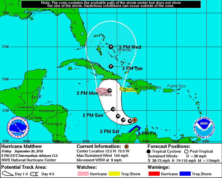
Hurricane Matthew, now a major hurricane, has undergone rapid intensification over the past 24 hours. The National Hurricane Center has posted Hurricane Watches for Jamaica, as the storm is expected to make landfall there as a category three storm in a few days. After making landfall in Jamaica and traversing Cuba, Matthew is expected to reemerge over The Bahamas as a strong category 2 or weak category 3 storm.

Pictured above is the HWRF computer model simulated Infrared Satellite image for Wednesday October 5. This image was provided by Tropicaltidbits.com.

As far as forecasting the track and intensity of Matthew after this point, not much can be said besides that the storm will either skim the Southeast’s coast before turning out to sea, or the storm will ride parallel near to the coast all the way up to Canada. Either way, Hurricane Matthew poses a serious threat to life and property in locations ranging from the Caribbean to the Eastern Seaboard. More updates will be available here, and on our Facebook page over the following several days, but for official information, please consult The National Hurricane Center at http://www.nhc.noaa.gov.

Hurricane Matthew.gif
Above is The National Hurricane Center’s projected path for Hurricane Matthew over the next 5 days. Hurricane watches are currently posted for all of Jamaica.


As Atlantic Hurricane Season Winds Down, Western Mexico Faces Major Hurricane Threat

10/22/15 8:00 PM AST: Hurricane Patricia strengthens rapidly to a Category 4 hurricane, Hurricane Warnings in place.

Although the Atlantic Hurricane Season is winding down, a massive Category 4 Hurricane Patricia is quickly moving towards the Central Mexican Pacific coastline.  This monster storm will also help bring massive amounts of rainfall to these areas along with parts of the Southern United States over the next several days.

The Forecast

At this time yesterday, Hurricane Patricia was only a Tropical Depression with sustained winds of only 35 MPH, and the forecast track was only suggesting the landfall at a maximum of a Category Two storm on the Mexican Coastline.  So what happened?

Well, since yesterday at this time, the forecast models have shifted as to support massive quick development of the storm due to warm ocean waters, and minimal wind shear.  Even though the official forecast track yesterday called for a moderate hurricane impact on the Mexican Coastline, some computer models such as the HWRF and the GFDL (Hurricane Computer Models) suggested that at least a potential Category Three storm impact was possible starting late on Tuesday.  These same computer models have steadily suggested a more violent impact since then.

For anyone with interests across along the Central-Pacific Mexican Coastline, please continue to monitor the storm and visit the NHC’s website for more information.

Tropical Storm Joaquin Expected to Strengthen and May Impact East Coast

Over the past several computer model runs, Tropical Storm Joaquin has been shown to become a large, violent hurricane and impact the East Coast, potentially anywhere from Virginia to Massachusetts.  Although there is a ‘general’ trend that shows the storm turn into the US East Coast, there are major differences in exact strength and location.

ECMWF VS GFS:

The 12z run of the ECMWF and the 18z run of the GFS have some very major differences.  For instance, the ECMWF shows a large and violent storm off of the coast of Florida, that quickly turns away out to sea and fizzles out over the open Atlantic.  The GFS shows a less strong storm developing near The Bahamas over the next several days and moving up the coast to impact mostly Virginia, Maryland, and Delaware initially, before moving up as a weaker system towards the rest of the Northeast.

At the moment though, it seems no matter what situation occurs, more than 10 inches of rain is likely to fall across the Northeast before next Wednesday.

We’ll continue to keep an eye on this system as its track becomes more and more clear.

Soon-To-Be Tropical Storm Joaquin Expected to Impact Northeast This Weekend

Over the past two days, Weather 360 has been monitoring the development of newly formed Tropical Depression Eleven (soon to be Tropical Storm Joaquin.)  Over the past 24 hours though, somewhat ludicrous information has been streaming out from many of the well regarded computer models.  This information includes that of a named Tropical Storm or potentially Hurricane, impacting the New England Coastline later this week and into the weekend.

The Stats:

Tropical Depression Eleven is currently moving west at 5 MPH, and is expected to make a sharp northerly turn over the next 48 hours towards the East Coast.  The current pressure is already 1003 Millibars, well ahead of the expected pressure and has sustained winds of 35 MPH with surface gusts reaching upwards of 40 MPH.  The storm is located north and east of The Bahamas and may threaten the following locations with Tropical Storm force or above winds:  Bermuda, New Jersey, New York, Connecticut, Rhode Island, Massachussetts, and potentially New Hampshire, and Maine.

The Computer Models:

At the moment, many of the different computer models are suggesting pretty much what the NHC track as of 5:00 PM EDT/AST suggests, a sharp turn to the north and potentially a re-curve to the west straight into locations such as New York, Connecticut, and New Jersey.

Please consult the National Hurricane Center and your emergency management office over the next few days as this becomes more and more certain to make your plan.

Tonight crucial in any future development of Tropical Storm Erika

As of 5:30 PM EDT/AST

With the newest NHC track and intensity update of Tropical Storm Erika rolling out, it is time to really stop and think, what is the single most important factor in Erika’s development, what is most crucial in the short term?  The answer is for the most part clear, and cloudy, but it is Hispaniola at the moment…

Hispaniola and the Storm Shredder’s

Sounds like a band, right?  Anyways, the mountains spread across central and southern portions of the two-nation island do inhibit development of tropical cyclones by ripping to shreds their center of circulation in the lower levels.  The mountains of Hispaniola are anywhere between 6,000 and 10,000 feet, tall enough to disrupt the centers and  other clouds at the lower levels.  So really it all comes down to the mountains over the next 12 to 18 hours, and if Erika is strong enough to at the least reemerge after its encounter with the land masses.

Official Alerts:

Tropical Storm Warnings are in effect for the entire length of the coasts of The Dominican Republic and Haiti, along with The Turks and Caicos along with most of The Bahamas.

Tropical Storm Watches are in effect for northeastern parts of Cuba and for locations in the northwestern portions of The Bahamas.

Weather 360 will continue to monitor the progress of Erika over the next several days.

Tropical Storm Erika may pose threat to entire East Coast if models hold through

BREAKING WEATHER NEWS: 3:45 PM EDT/AST

It is now almost 4 o’clock across the Eastern Seaboard of the US and with the latest run of the computer model runs, some fairly intriguing information has come out as well.

What’s happening?

As of the 12 UTC update, several computer models that do bring Erika up the East Coast, also bring Erika to Category 4 and Category 5 status while nearing the Outer Banks.  This could, if true, mean that a potential catastrophic disaster could be felt anywhere from Florida, to New England, with that in mind, we do remind you that some computer models do still bring a weaker system into Florida, which would avert a potential catastrophe.  For anyone from Florida to New England, we do advise to at least be thinking about preparation for this potential storm.

For those in the Caribbean Islands, including Hispaniola, The Turks and Caicos, and The Bahamas, we recommend immediate action, as we expect a slight shift in the track by the NHC over the next hour.

Bottom Line:  BE PREPARED, Don’t let a storm catch you off guard.

We will continue to keep you updated on the progress of Erika.

Computer models pointing to the rapid development of Invest 91-E in the Eastern Pacific

AS OF 9:30 PM EDT 7/28/2015

The National Hurricane Center in their most recent update on the Eastern Pacific indicates the growing support among the computer models of a rapidly growing storm in the Eastern Pacific.  At the moment, the National Hurricane Center has odds of development for this storm over the next five days at 90%, an increase of 20% in two days, along with the odds of development over the next 48 hours up to 30%, up 30% from two and a half days ago.

Why would this tropical disturbance develop if the last one to develop failed so miserably?

First of all, this time around, the shorter range computer models did not really at one point indicate that former Invest 90-E (now weakening Tropical Depression Eight-E) would develop into a massive storm, but this still does not give reason to why Invest 91-E would develop.  The reason for the increased odds of development for Invest 91-E (as opposed to Invest 90-E) is due to the warmer waters.  Invest 91-E is further to the south than Invest 90-E was at the same longitude.  This along with the fact that the ridges of high pressure steering this storm bring it into an area where wind shear (upper level winds that tear off the tops of Tropical Cyclones), is relatively at the point where there is close to zero of this phenomena.

All the ingredients are at the moment seeming to come together for what could potentially be a much larger tropical event than of its most recent predecessor, former Invest 90-E.

So for more updates regarding this storm system, stay tuned to Weather 360, and for emergency information, contact your Local Emergency Management Office if you are in the path of any current, or future storm.