Peak Activity: The Tropical Atlantic Heats Up

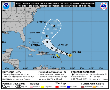
September 19, 2019 – Category 1 Hurricane Jerry is the latest addition to the National Hurricane Center Tropical Weather Outlook this evening. The 90 mph storm is moving to the west-northwest and threatens the Leeward Islands, where Tropical Storm Watches are currently in effect, as well as Bermuda, which is still experiencing rough waters from the once Major Hurricane Humberto.

Hurricane Jerry 9 19 19.png
Hurricane Jerry, a relatively small storm as of the evening of September 19, poses a threat for the northern Leeward Islands as well as Bermuda over the next seven days.

Further to the west, the remnants of Tropical Storm Imelda continues to wreak havoc in Texas – where upwards of 40″ of rain have now fallen to the east of Houston. Large swaths of southeastern Texas, which were also slammed by the historic rainfall from Hurricane Harvey in 2017, are under Flash Flood and Flood Warnings.

The Rest of the Atlantic

  • Now Category 2 Hurricane Humberto continues to move to the north and east away from Bermuda with winds in excess of 105 mph.
  • Two areas with low probability of development over the next five days are moving into and through the Caribbean Sea.
  • A disturbance moving off the Africa has a 50% chance at developing into a Tropical Depression over the next five days. The most immediate effects of this potential storm could be felt in the Cape Verde islands.

For more information regarding the impacts of Imelda, please visit http://www.weather.gov. For more information regarding the progress of Hurricanes Jerry and Humberto, as well as the three noted areas of potential development, please visit http://www.nhc.noaa.gov.

More updates both here and on our Facebook page as conditions warrant.

Stay safe!

Hurricane Dorian: What You Need to Know

Category 4 Major Hurricane Dorian is barreling towards the US East Coast.  The storm, which has rapidly intensified over the past several hours, is expected to reach the Bahamas by Sunday afternoon.

What you need to know:

The Saffir-Simpson Scale:
Category 5: 157+ mph - Catastrophic Damage
Category 4: 130-156 mph - Catastrophic Damage
Category 3: 111 - 129 mph - Devastating Damage
Category 2: 96 - 110 mph - Extensive Damage
Category 1: 74 - 95 mph - Some Damage

As of the evening of August 30, 2019, Hurricane Dorian is a category 4 major hurricane with sustained winds of 130 mph and a central pressure of 950 millibars.

The current National Hurricane Center forecast cone keeps Florida in the cross-hairs. This afternoon, computer model guidance shifted the projected storm path eastward, placing locations from Miami to as far north as South Carolina under the threat of winds well in excess of 100 mph, excessive rainfall, and significant storm surge.

NHC Hurricane Dorian.png
The National Hurricane Center’s official track guidance as of 8 PM EDT on August 30, 2019. Hurricane Warnings (red) and Hurricane Watches (pink) have been issued for the Bahamas. This graphic depicts the potential storm center paths – not the potential extent of storm impacts.

The 8 PM EDT update from the National Hurricane Center has a category 4 storm making landfall near Port Saint Lucie, Florida. While there continues to exist uncertainty in the track of this storm, should this occur, storm surge well in excess of 7-11+ feet is possible on the coast of central eastern Florida, with top sustained winds potentially exceeding 130 – 140 mph in a radius reaching tens of miles from the center of the storm.

Who in the United States mainland will bear the brunt of this storm is still unknown. The storm will make a turn northward as it is picked up by a ridge of high pressure situated over the western Atlantic. When this storm makes its turn northward is still uncertain. 

It is vital that everyone on the US East Coast from Miami to South Carolina – and even further north – be prepared to act quickly ahead of this storm. 

Please prepare now and stay updated on local guidance and evacuation information from the National Hurricane Center (nhc.noaa.gov), the National Weather Service (weather.gov), and your local emergency management office.

Weather360 will continue to keep you updated on the progress of this storm both here and on our Facebook page.

Be prepared and stay safe!

2019 Hurricane Season Outlook

Colorado State University has recently released its 2019 Hurricane Season Outlook and is calling for a slightly below average hurricane season. The Colorado State University outlook for the Atlantic Hurricane Season has long been one of the staples used in the long-term forecasting of how violent or active a particular hurricane season will be.

This year, the CSU forecast (as of April) is calling for an expected total of 13 named tropical cyclones (the average is 12), 5 hurricanes (the average is 6), and 2 major hurricanes (the average is 3). This forecast is based on various points of data, including recent measurements indicating that the Tropical Atlantic is slightly cooler than average for this time of year. Check out the full report here.

CANSIPS shear estimate

CANSIPS shear estimate 2
Above are computer model forecasts, made available by TropicalTidbits.com, for this coming hurricane season. This particular model, the CanSIPS, is forecasting increased areas of wind shear (generally less favorable for hurricane development) across the lower Caribbean from August to November. This by does not rule out the presence or development of hurricanes or other cyclones in the Caribbean Sea.

The Atlantic Hurricane Season begins on June 1 and lasts until November 30, during which time, as with any year, there will most likely be several potentially life-threatening cyclones in the basin. Despite the slightly reduced risk for tropical cyclones, please remain vigilant throughout the late spring, summer, and fall for further developments.

If you live in an area prone to hurricanes or tropical storms, now is the best time to get prepared. Ensure you have a proper emergency supplies kit and other essentials by visiting https://www.ready.gov.

Stay safe!


Catastrophic and Unprecedented Hurricane Michael Makes Landfall in Florida

The eye wall of the now 150 mph Hurricane Michael is making landfall near Panama City, Florida. This storm has rapidly increased in strength over the past 24, 48, and 72 hours to become a now unprecedented event in the history of the Florida Panhandle.

Hurricane Michael Image
Hurricane Michael, a strong Category 4 hurricane, making landfall several miles to the east of Panama City, Florida. (1:30 pm ET October 10, 2018)

The National Hurricane Center has forecasted storm surge to exceed 14 feet in some locations in the Big Bend region of northwestern Florida. The NHC has also extended Hurricane Warnings as far inland as southeastern Georgia, with Tropical Storm Warnings extending as far north as the Outer Banks of North Carolina.

Weather.gov Hurricane Michael.png
Due to the fast-moving nature of Hurricane Michael, the storm will remain at tropical storm or hurricane strength as it traverses the Southeast United States. (Image Source: Weather.gov)

The National Weather Service has also extended Extreme Wind Warnings for locations from Panama City to Apalachicola as the eye wall continues to bring winds in excess of 130-150 mph onshore.

Hurricane Michael has made history, not only as being the first category 4 hurricane to make landfall in the Florida Panhandle, nor only with its being  the lowest pressure (919 millibars) recorded in the area, but also with its having formed and struck in the month of October.

For more information regarding Hurricane Michael and its effects, please consult the National Hurricane Center at http://www.nhc.noaa.gov, or the National Weather Service at http://www.weather.gov.

Stay safe!

Massive Hurricane Florence to Slam the Carolinas

Hurricane Florence, now a major category 3 hurricane with winds in excess of 115 mph, is expected to restrengthen as it makes its way towards the coast. Storm Surge and Hurricane Warnings are in effect from Myrtle Beach, South Carolina, to the northern Outer Banks in North Carolina, with Hurricane Watches extending as far south as Charleston.

Florence NHC Track 09 12 18.png
Official NHC track and wind field assessment as of 8:00 PM ET on September 12, 2018.

Although the effects of Hurricane Florence will begin to impact the Carolinas starting tomorrow afternoon, strong winds and heavy rain will continue to lash the region until the end of the weekend due to the storm’s unusual path.

Florence NAM 3KM Future Radar 09 12 18.png
This is the  18z 9/12/18 run of the NAM 3km computer model depicting an extremely intense Hurricane Florence approaching the Wilmington, NC area.

For the past several days, computer model guidance has shifted to suggesting that Hurricane Florence will begin to slow down and proceed to parallel the coastline come Friday evening. The storm’s unusual path will force extremely dangerous winds and storm surge across a swath of land extending from the Outer Banks to South Carolina, placing millions under the threat of life-threatening conditions. Unfortunately, these conditions will only be compounded and exacerbated by the upwards of 3 feet of rain forecasted to fall in some areas.

The National Hurricane Center is forecasting winds to exceed 120 mph upon Hurricane Florence’s arrival near the coastline, with a storm surge exceeding 9-13 feet in some locations, making this storm extremely dangerous for those in its path.

If you have been ordered or asked to evacuate, please heed these orders immediately before it becomes too late to do so. All preparations for this storm should be completed immediately.

For more information, please consult the National Hurricane Center at http://www.nhc.noaa.gov or your local emergency management office.

Less Than Two Weeks After Irma, Maria Promises to Slam Caribbean as Monster Category 5

Hurricane Maria has intensified from a category 1 to a monster category 5 hurricane in under 48 hours. The now 160 mph storm is expected to strengthen further as it makes its first landfall in the eastern Caribbean before making a direct hit on the Virgin Islands and Puerto Rico. Maria possesses winds equivalent to that of an EF 3 to EF 4 tornado and is moving at less than 10 mph, meaning the worst of its winds will bear down on the same locations for up to 6 hours at a time (keep in mind that a tornado typically spends around 30 seconds to 2 minutes affecting one single location). The National Hurricane Center forecasts Hurricane Maria to make landfall in southeastern Puerto Rico as a category 5 storm with sustained winds of 160 mph. The already devastated US and British Virgin Islands can expect extreme winds and rain as well as storm surge over the next 48 hours. This will cause catastrophic damage across Puerto Rico and the Dominican Republic as well.

Hurricane Maria.png
The National Hurricane Center’s cone of uncertainty regarding Maria’s potential track, the storm is also expected to expand as it approaches Puerto Rico and the Virgin Islands.

Following its landfall in Puerto Rico, Maria is expected to track into the eastern Bahamas as a category 3 or 4 storm as it continues to move northwestward, potentially impacting the US East Coast over the next week and a half. For further information, please consult the National Hurricane Center at http://www.nhc.noaa.gov and the National Weather Service at http://www.weather.gov.

Major Hurricane Matthew Taking Aim at Carribean

Hurricane Matthew, now a major hurricane, has undergone rapid intensification over the past 24 hours. The National Hurricane Center has posted Hurricane Watches for Jamaica, as the storm is expected to make landfall there as a category three storm in a few days. After making landfall in Jamaica and traversing Cuba, Matthew is expected to reemerge over The Bahamas as a strong category 2 or weak category 3 storm.

Pictured above is the HWRF computer model simulated Infrared Satellite image for Wednesday October 5. This image was provided by Tropicaltidbits.com.

As far as forecasting the track and intensity of Matthew after this point, not much can be said besides that the storm will either skim the Southeast’s coast before turning out to sea, or the storm will ride parallel near to the coast all the way up to Canada. Either way, Hurricane Matthew poses a serious threat to life and property in locations ranging from the Caribbean to the Eastern Seaboard. More updates will be available here, and on our Facebook page over the following several days, but for official information, please consult The National Hurricane Center at http://www.nhc.noaa.gov.

Hurricane Matthew.gif
Above is The National Hurricane Center’s projected path for Hurricane Matthew over the next 5 days. Hurricane watches are currently posted for all of Jamaica.


As Atlantic Hurricane Season Winds Down, Western Mexico Faces Major Hurricane Threat

10/22/15 8:00 PM AST: Hurricane Patricia strengthens rapidly to a Category 4 hurricane, Hurricane Warnings in place.

Although the Atlantic Hurricane Season is winding down, a massive Category 4 Hurricane Patricia is quickly moving towards the Central Mexican Pacific coastline.  This monster storm will also help bring massive amounts of rainfall to these areas along with parts of the Southern United States over the next several days.

The Forecast

At this time yesterday, Hurricane Patricia was only a Tropical Depression with sustained winds of only 35 MPH, and the forecast track was only suggesting the landfall at a maximum of a Category Two storm on the Mexican Coastline.  So what happened?

Well, since yesterday at this time, the forecast models have shifted as to support massive quick development of the storm due to warm ocean waters, and minimal wind shear.  Even though the official forecast track yesterday called for a moderate hurricane impact on the Mexican Coastline, some computer models such as the HWRF and the GFDL (Hurricane Computer Models) suggested that at least a potential Category Three storm impact was possible starting late on Tuesday.  These same computer models have steadily suggested a more violent impact since then.

For anyone with interests across along the Central-Pacific Mexican Coastline, please continue to monitor the storm and visit the NHC’s website for more information.

Joaquin Expected to Impact Bermuda, Watches and Warnings Issued

Weather Bulletin – 10/3/2015 2 PM AST

The National Hurricane Center in Miami Florida has issued a Tropical Storm Warning and a Hurricane Watch for the Islands of Bermuda.  The strong Category Four Hurricane Joaquin is now moving quickly to the northeast towards Bermuda.  Joaquin’s center is expected to pass within 75 miles to the west of Bermuda in about two days, as a potentially high Category Two, or low-grade Category Three storm.  Due to Joaquin’s potential proximity to the island nation, the  NHC urges residents to take precautions immediately and to be prepared for the worst.

We’ll keep you posted – Weather 360

Tonight crucial in any future development of Tropical Storm Erika

As of 5:30 PM EDT/AST

With the newest NHC track and intensity update of Tropical Storm Erika rolling out, it is time to really stop and think, what is the single most important factor in Erika’s development, what is most crucial in the short term?  The answer is for the most part clear, and cloudy, but it is Hispaniola at the moment…

Hispaniola and the Storm Shredder’s

Sounds like a band, right?  Anyways, the mountains spread across central and southern portions of the two-nation island do inhibit development of tropical cyclones by ripping to shreds their center of circulation in the lower levels.  The mountains of Hispaniola are anywhere between 6,000 and 10,000 feet, tall enough to disrupt the centers and  other clouds at the lower levels.  So really it all comes down to the mountains over the next 12 to 18 hours, and if Erika is strong enough to at the least reemerge after its encounter with the land masses.

Official Alerts:

Tropical Storm Warnings are in effect for the entire length of the coasts of The Dominican Republic and Haiti, along with The Turks and Caicos along with most of The Bahamas.

Tropical Storm Watches are in effect for northeastern parts of Cuba and for locations in the northwestern portions of The Bahamas.

Weather 360 will continue to monitor the progress of Erika over the next several days.