Less Than Two Weeks After Irma, Maria Promises to Slam Caribbean as Monster Category 5

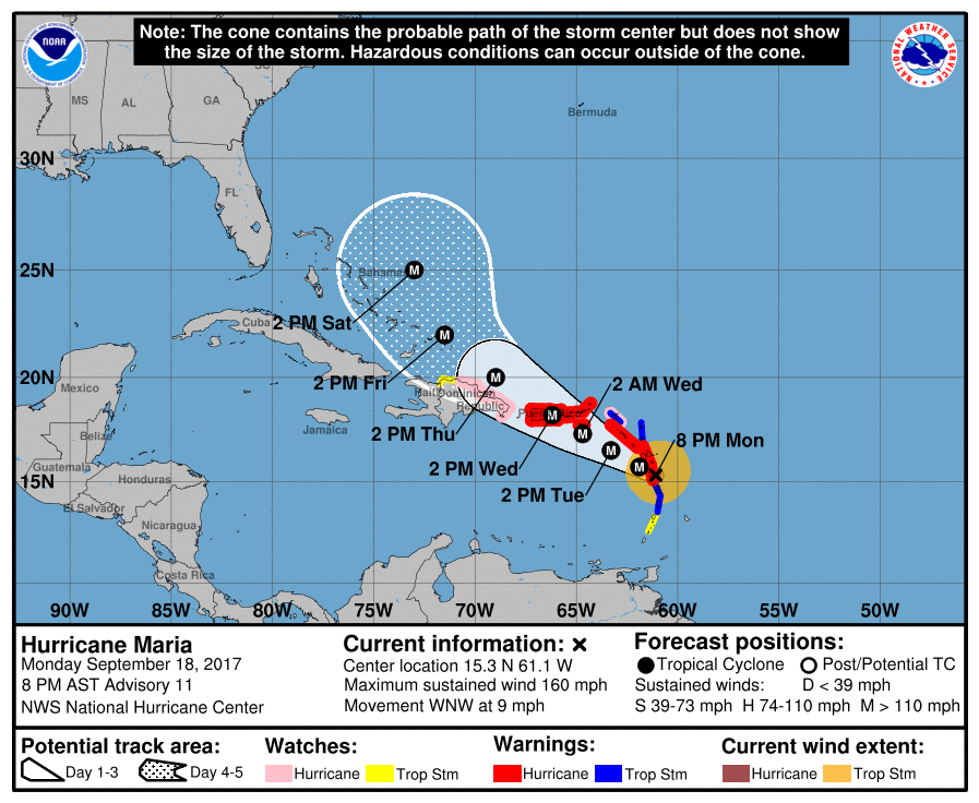
Hurricane Maria has intensified from a category 1 to a monster category 5 hurricane in under 48 hours. The now 160 mph storm is expected to strengthen further as it makes its first landfall in the eastern Caribbean before making a direct hit on the Virgin Islands and Puerto Rico. Maria possesses winds equivalent to that of an EF 3 to EF 4 tornado and is moving at less than 10 mph, meaning the worst of its winds will bear down on the same locations for up to 6 hours at a time (keep in mind that a tornado typically spends around 30 seconds to 2 minutes affecting one single location). The National Hurricane Center forecasts Hurricane Maria to make landfall in southeastern Puerto Rico as a category 5 storm with sustained winds of 160 mph. The already devastated US and British Virgin Islands can expect extreme winds and rain as well as storm surge over the next 48 hours. This will cause catastrophic damage across Puerto Rico and the Dominican Republic as well.

Hurricane Maria.png
The National Hurricane Center’s cone of uncertainty regarding Maria’s potential track, the storm is also expected to expand as it approaches Puerto Rico and the Virgin Islands.

Following its landfall in Puerto Rico, Maria is expected to track into the eastern Bahamas as a category 3 or 4 storm as it continues to move northwestward, potentially impacting the US East Coast over the next week and a half. For further information, please consult the National Hurricane Center at http://www.nhc.noaa.gov and the National Weather Service at http://www.weather.gov.

Tonight crucial in any future development of Tropical Storm Erika

As of 5:30 PM EDT/AST

With the newest NHC track and intensity update of Tropical Storm Erika rolling out, it is time to really stop and think, what is the single most important factor in Erika’s development, what is most crucial in the short term?  The answer is for the most part clear, and cloudy, but it is Hispaniola at the moment…

Hispaniola and the Storm Shredder’s

Sounds like a band, right?  Anyways, the mountains spread across central and southern portions of the two-nation island do inhibit development of tropical cyclones by ripping to shreds their center of circulation in the lower levels.  The mountains of Hispaniola are anywhere between 6,000 and 10,000 feet, tall enough to disrupt the centers and  other clouds at the lower levels.  So really it all comes down to the mountains over the next 12 to 18 hours, and if Erika is strong enough to at the least reemerge after its encounter with the land masses.

Official Alerts:

Tropical Storm Warnings are in effect for the entire length of the coasts of The Dominican Republic and Haiti, along with The Turks and Caicos along with most of The Bahamas.

Tropical Storm Watches are in effect for northeastern parts of Cuba and for locations in the northwestern portions of The Bahamas.

Weather 360 will continue to monitor the progress of Erika over the next several days.

Tropical Storm Erika may pose threat to entire East Coast if models hold through

BREAKING WEATHER NEWS: 3:45 PM EDT/AST

It is now almost 4 o’clock across the Eastern Seaboard of the US and with the latest run of the computer model runs, some fairly intriguing information has come out as well.

What’s happening?

As of the 12 UTC update, several computer models that do bring Erika up the East Coast, also bring Erika to Category 4 and Category 5 status while nearing the Outer Banks.  This could, if true, mean that a potential catastrophic disaster could be felt anywhere from Florida, to New England, with that in mind, we do remind you that some computer models do still bring a weaker system into Florida, which would avert a potential catastrophe.  For anyone from Florida to New England, we do advise to at least be thinking about preparation for this potential storm.

For those in the Caribbean Islands, including Hispaniola, The Turks and Caicos, and The Bahamas, we recommend immediate action, as we expect a slight shift in the track by the NHC over the next hour.

Bottom Line:  BE PREPARED, Don’t let a storm catch you off guard.

We will continue to keep you updated on the progress of Erika.

Tropical Storm Erika bears down on Caribbean, and may hit the East Coast soon

As of 7:00 AM EDT/AST

Tropical Storm Erika now has winds sustained at 45 knots (50 MPH), and a pressure of about 1003 millibars.  The storm will likely continue to west-northwestward track at about 15 mph and impact Puerto Rico, the Virgin Islands, parts of Hispaniola, the Turks and Caicos, and The Bahamas over the next few days.

Let’s Talk Track

Overnight, the main computer models along with many spaghetti models seem to have locked in on their track for Tropical Storm Erika, the newest main track calls for a turn to the north, as expected, while over the Bahamas, leaving most of the state of Florida likely in the clear.  Over the next few days, Tropical Storm Erika will ride over the Virgin Islands and Puerto Rico, skim northeastern parts of Hispaniola, do a direct hit on the Turks and Caicos and The Bahamas, and skim the Eastern Florida coastline.

The Computer Models, What’s New?

As said before, the spaghetti models along with all the global computer models have seemed to lock in their newest projection for Erika’s track to at least parts of the East Coast, but what about intensity?  Of course, along with track, the intensity must change as well, and believe us when we say change.  One may not think the following change is any more than moderately significant, but in truth, even a difference of about 10 MPH in wind speed can mean the difference between little and major damage.  At the same time yesterday, the spaghetti intensity models where still all over the place, but as of last night,  more and more computer models became more grouped together, leaving us with two main possibilities, either this storm will strengthen rapidly over the Bahamas, or Erika will strengthen over the next several days slowly.  Both of these possibilities do say there would be a hurricane either of above Category Three status, or mid-grade Category One status in about 5 days.

Most Global Computer Models such as the GFS and the ECMWF, will became a bit more infrequently used in the immediate track, meaning that over the next few days, the shorter range and more accurate computer models will be given a bigger shot at Tropical Storm Erika.

Official Alerts:  Tropical Storm Warnings are in effect for the northern Leeward Islands, The Virgin Islands, and Puerto Rico.  Tropical Storm Watches remain in effect for southern parts of the Leeward Islands, northern portions of the Dominican Republic, the Turks and Caicos, and the southern parts of the Bahamas.

Weather 360 3.A.S.:  Level I Emergency for locations under Tropical Storm Warnings,  Level II Alert for locations under Tropical Storm Watches, and a  Level III, be aware statement, for locations from Miami to The Outer Banks along with the entirety of the Eastern Seaboard.

Weather 360 will continue to keep you updated on the progress of Tropical Storm Erika, stay safe!
Tropical Storm Erika takes aim on Caribbean Islands, but then what?

As of 7:00 AM EDT/AST

Tropical Storm Erika has sustained Winds of about 45 MPH, with gusts from 50 to 60 MPH.  The storm is moving to the west-northwest at 20 mph towards the Leeward Islands, the Virgin Islands, Puerto Rico, Hispaniola, and the Bahamas.

The Track

Tropical Storm Erika is expected to keep a track trough the northern Leeward Islands, the Virgin Islands, and Puerto Rico. Already due to this threat, Tropical Storm Watches have been issued for parts of the Leeward Islands.  After skimming parts of Hispaniola with its southern side, Erika will begin to move towards the Bahamas, but it is after here where things get interesting.

Let’s talk computer models

For a start, the European Computer Model (ECMWF or Euro) suggests that Erika will stall just north of the Bahamas due to a somewhat aggravating high pressure, this would happen likely until the high pressure moves to the east, then Erika would be allowed to trek the East Coast as a potentially monster-like storm.  Of course, we still have several days to go until we know exactly the final destination for Erika, which is officially expected to become a hurricane by the National Hurricane Center in Miami, Florida.

Let’s bring in some of our spaghetti models now… Let’s start with some of the intensity computer models.  At the moment, the majority of the computer models seem to bring Erika to hurricane strength in about 3-5 days, and continue it on a strengthening path after that.  So there is limited disagreement between the current intensity models, but the spaghetti computer track models do have some disagreement on whether Erika will trek into the Gulf, or track up the coast at least to some degree.

Official Alerts: Tropical Storm Watches in effect for the Leeward Islands.

Weather 360 3.A.S.: Level III Alert, be aware that the potential for hazardous weather over the next two weeks may be felt along the US Southeast Coastline due to Tropical Storm Erika.

We here at Weather 360 will continue to keep you updated.