Hurricane Dorian: What You Need to Know

Category 4 Major Hurricane Dorian is barreling towards the US East Coast.  The storm, which has rapidly intensified over the past several hours, is expected to reach the Bahamas by Sunday afternoon.

What you need to know:

The Saffir-Simpson Scale:
Category 5: 157+ mph - Catastrophic Damage
Category 4: 130-156 mph - Catastrophic Damage
Category 3: 111 - 129 mph - Devastating Damage
Category 2: 96 - 110 mph - Extensive Damage
Category 1: 74 - 95 mph - Some Damage

As of the evening of August 30, 2019, Hurricane Dorian is a category 4 major hurricane with sustained winds of 130 mph and a central pressure of 950 millibars.

The current National Hurricane Center forecast cone keeps Florida in the cross-hairs. This afternoon, computer model guidance shifted the projected storm path eastward, placing locations from Miami to as far north as South Carolina under the threat of winds well in excess of 100 mph, excessive rainfall, and significant storm surge.

NHC Hurricane Dorian.png
The National Hurricane Center’s official track guidance as of 8 PM EDT on August 30, 2019. Hurricane Warnings (red) and Hurricane Watches (pink) have been issued for the Bahamas. This graphic depicts the potential storm center paths – not the potential extent of storm impacts.

The 8 PM EDT update from the National Hurricane Center has a category 4 storm making landfall near Port Saint Lucie, Florida. While there continues to exist uncertainty in the track of this storm, should this occur, storm surge well in excess of 7-11+ feet is possible on the coast of central eastern Florida, with top sustained winds potentially exceeding 130 – 140 mph in a radius reaching tens of miles from the center of the storm.

Who in the United States mainland will bear the brunt of this storm is still unknown. The storm will make a turn northward as it is picked up by a ridge of high pressure situated over the western Atlantic. When this storm makes its turn northward is still uncertain. 

It is vital that everyone on the US East Coast from Miami to South Carolina – and even further north – be prepared to act quickly ahead of this storm. 

Please prepare now and stay updated on local guidance and evacuation information from the National Hurricane Center (nhc.noaa.gov), the National Weather Service (weather.gov), and your local emergency management office.

Weather360 will continue to keep you updated on the progress of this storm both here and on our Facebook page.

Be prepared and stay safe!

Catastrophic and Unprecedented Hurricane Michael Makes Landfall in Florida

The eye wall of the now 150 mph Hurricane Michael is making landfall near Panama City, Florida. This storm has rapidly increased in strength over the past 24, 48, and 72 hours to become a now unprecedented event in the history of the Florida Panhandle.

Hurricane Michael Image
Hurricane Michael, a strong Category 4 hurricane, making landfall several miles to the east of Panama City, Florida. (1:30 pm ET October 10, 2018)

The National Hurricane Center has forecasted storm surge to exceed 14 feet in some locations in the Big Bend region of northwestern Florida. The NHC has also extended Hurricane Warnings as far inland as southeastern Georgia, with Tropical Storm Warnings extending as far north as the Outer Banks of North Carolina.

Weather.gov Hurricane Michael.png
Due to the fast-moving nature of Hurricane Michael, the storm will remain at tropical storm or hurricane strength as it traverses the Southeast United States. (Image Source: Weather.gov)

The National Weather Service has also extended Extreme Wind Warnings for locations from Panama City to Apalachicola as the eye wall continues to bring winds in excess of 130-150 mph onshore.

Hurricane Michael has made history, not only as being the first category 4 hurricane to make landfall in the Florida Panhandle, nor only with its being  the lowest pressure (919 millibars) recorded in the area, but also with its having formed and struck in the month of October.

For more information regarding Hurricane Michael and its effects, please consult the National Hurricane Center at http://www.nhc.noaa.gov, or the National Weather Service at http://www.weather.gov.

Stay safe!

Tropical Depression Nine Expected to Become a Tropical Storm Today; Track Uncertainty Remains in the Long Term

Tropical Depression 9, the swirling mass of clouds just to the north of The Yucatan in the image to the left, is expected to intensify into a Tropical Storm sometime over the next several hours. The warm waters of The Gulf combined with little shear has finally allowed this storm to grow rapidly over the past couple of days. The National Hurricane Center (NHC) has issued Hurricane Watches as well as Tropical Storm Warnings for much of the Big Bend area of Florida north of Tampa. Although the storm is not currently expected to become a hurricane before landfall,  it will come close to doing so with sustained winds of about 65 MPH, so Hurricane Watches are still in effect for the area. Although a sort of model consensus has been reached regarding the short term for this storm, mayhem continues as some computer models have begun to indicate a shift to the west once it passes North Carolina. If this storm were to shift to the west as now indicated by some of the more trustworthy computer models, it would mean that impacts from this storm would be felt as far north as New England.  As of now, The NHC has put a 50% chance of a 3 to 5 foot storm surge occurring in The Long Island Sound, but until the computer models receive more information, it is unlikely we will know the exact track.  More updates will ne available here over the next several days, but please visit The National Hurricane Center at nhc.noaa.gov before making any decisions.

Tropical Depressions Take Aim at US Coast

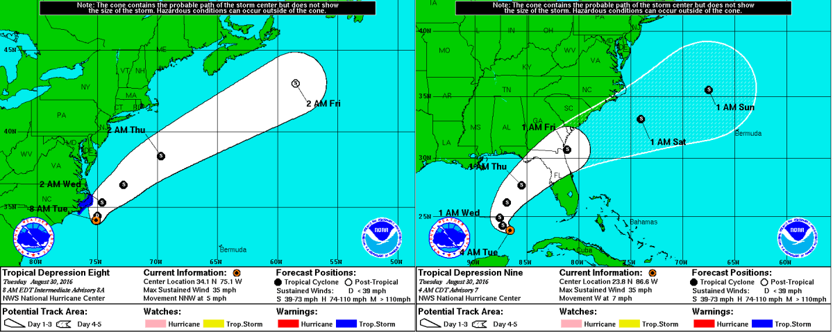
Tropical Depression 8 as well as Tropical Depression 9 are now expected to impact The US as Tropical Storms. Tropical Depression 8 is currently nearing The Outer Banks and is expected to strengthen to a Tropical Storm soon, prompting Tropical Storm Warnings for nearly the entire Outer Banks.  Tropical Depression 9 has finished moving into the southeastern Gulf of Mexico as of this morning, and is expected to become a Tropical Storm over the next 48 hours as it begins its northeast turn towards Florida.  After impacting portions of northwestern Florida, the storm is expected to reemerge over The Atlantic and continue to head to the northeast. Recently, some computer models such as The JMA (Based in Japan), The CMC (Based in Canada, as well as The UKMET (Based in The UK), have suggested a turn to the north and northwest, towards the coast of The Mid-Atlantic. There is no cause for concern quite yet for those in and around NYC, but   Weather 360 will continue to monitor the situation.

TD8 TD9 Track NHC 83016.png
Tropical Depression 8 (left) has prompted Tropical Storm Warnings for The Outer Banks of North Carolina, and Tropical Depression 9 (right) is making its way towards Florida. These images are distributed by The National Hurricane Center in Miami, Florida.

Invest 99L Expected to Impact US; Intensity Remains Uncertain

Invest 99L formed east of the Leeward Islands as a Tropical Wave about 10 days ago, since then, the storm has made its way to The Straits of Florida, where it is currently attempting to organize itself. Recent satellite images have indicated that the storm is beginning to regain a center of circulation, and recent computer model runs have suggested a potential hurricane impacting portions of western Florida over the following several days.

Although coming closer to the potential time of impact, the storm is not yet organized to the point at which the National Hurricane Center may issue advisories, and a model consensus has by no means yet been reached. Weather 360 will continue to provide updates on Invest 99L on here and on our Hurricane Center page over the coming days.


Invest 99L Poses Threat to US Mainland

Invest 99L is an area of disturbed weather and thunderstorms currently moving west-northwestward at about 20 mph just east of the Leeward Islands. The storm has already defied some expectations that further organization would stall until the area of low pressure moved closer to Hispaniola, and has prompted an Air Force Reserve Hurricane Hunter aircraft trip into the storm later this morning. In the short term, a bit of a model consensus has been reached in terms of whether will the storm go north or south of Hispaniola, and over the past several days, more and more computer models have moved their tracks further to the north of the cyclone-killing mountains in Haiti and The Dominican Republic. The most likely storm track is as follows;  the storm will likely go north of Hispaniola and into the Bahamas before either being pulled north, or continuing on a track west over Florida (Sorry for the uncertainty, it’s still a bit early…) The most likely tracks do have one thing in common beyond the short term track though; most suggest landfall of at least a Tropical Depression somewhere on the East Coast of The United States. Whether the storm traverses Florida and makes another landfall somewhere in the Gulf before being pulled back into The Atlantic, or whether the storm moves up The East Coast, The United States will likely be impacted in some way, shape, or form by what is now Invest 99L.  It is important for those on The East Coast of The United States as well as those on the west coast of Florida to monitor the situation as it progresses and to stay tuned to updates from the National Hurricane Center.

Here's a look at The Tropical Atlantic Basin Satellite Imagery. 
Tropical Depression Fiona is north of The Leeward Islands, 
Invest 99L is east of the Leeward Islands,
And Tropical Storm Gastone is just west of The Cape Verde Islands.

More detail regarding Computer Model variations and outcomes can be found at our Hurricane Center page, where Weather360 is currently covering Invest 99L, Tropical Storm Gastone, as well as Tropical Depression Fiona in The Atlantic.

Remnants of Erika may redevelop, Tropical Storm Fred forms, Hurricane Ignacio may impact Hawaii

End of August Weather Overview: 2 PM EDT/AST, 8 AM HST August 30th 2015

Erika Redevelopment Recap

Over the past several days the weather world has been keeping a close eye on Erika, just about until yesterday, when it became a remnant low off the northern coast of Cuba.  After that point at 9:30 yesterday, almost all hope was lost for the redevelopment of Erika, but according to some short range computer models, the remnants moving northward across Central Florida, may redevelop a center of circulation soon off the Southeastern Coast.  So we’ll keep a close watch on this system over the upcoming several days.

Tropical Storm Fred Overview

Tropical Storm Fred formed yesterday off the coast of the Cape Verde Islands and is expected to become a hurricane while moving further northwest towards the central Atlantic.  Fred will thereafter weaken to a Tropical Storm once more and move quite quickly through the central Atlantic, the eventual destination is still at this point unknown.

Hawaii Hurricane Threat

Hurricane Ignacio is now a Category Four storm with winds upwards of 140 MPH, this storm is barreling to the northwest and is expected to graze the northern sides of the islands of Maui and the Big Island.  At the moment, Tropical Storm Watches are in effect for locations within The Big Island and all of Maui County.  For those with interests in the islands potentially affected by the storm, please continue to monitor the progress of this storm over the upcoming few days.

Weather 360 will continue to keep you updated on all of these threats over the coming days.

Tonight crucial in any future development of Tropical Storm Erika

As of 5:30 PM EDT/AST

With the newest NHC track and intensity update of Tropical Storm Erika rolling out, it is time to really stop and think, what is the single most important factor in Erika’s development, what is most crucial in the short term?  The answer is for the most part clear, and cloudy, but it is Hispaniola at the moment…

Hispaniola and the Storm Shredder’s

Sounds like a band, right?  Anyways, the mountains spread across central and southern portions of the two-nation island do inhibit development of tropical cyclones by ripping to shreds their center of circulation in the lower levels.  The mountains of Hispaniola are anywhere between 6,000 and 10,000 feet, tall enough to disrupt the centers and  other clouds at the lower levels.  So really it all comes down to the mountains over the next 12 to 18 hours, and if Erika is strong enough to at the least reemerge after its encounter with the land masses.

Official Alerts:

Tropical Storm Warnings are in effect for the entire length of the coasts of The Dominican Republic and Haiti, along with The Turks and Caicos along with most of The Bahamas.

Tropical Storm Watches are in effect for northeastern parts of Cuba and for locations in the northwestern portions of The Bahamas.

Weather 360 will continue to monitor the progress of Erika over the next several days.

Tropical Storm Erika may impact Southeast Coast, but will it make it there?

As of 11:30 AM EDT/AST

Tropical Storm Erika has sustained winds of about 50 MPH with gusts upwards of 60 MPH.  The storm is moving west-northwestward at the moment over the Dominican Republic.  Tropical Storm Warnings are still in effect for Puerto Rico, the Virgin Islands, parts of The Turks and Caicos along with The Bahamas, and all of Hispaniola.  Hurricane Hunter Aircraft are in the storm.

The Track

This image is made public by the South Florida Water Management District (.gov)

The track seems to be locking in and narrowing down, well, at least compared to yesterday at this time, but nonetheless, the expected track and intensity are still at a state of ‘low confidence’ as mentioned by the NHC in their latest Tropical Forecast Discussion.  The general trend though, is that the storm will pass over Hispaniola over the next day, then turn northward toward Florida, then possibly re curving, to go back over the Atlantic and to head up the East Coast.  For those in Florida or along the Southeast Coast of the United States, please continue to monitor the situation, as the cone of uncertainty continues to include the possibility of a major storm impacting the Eastern Seaboard.

Intensity, Will She Survive?

Who knows, Erika is seeming to have a mind of her own as she has not followed the official NHC track whatsoever over the last several days.  Although this is true, over the past hour or two Erika has seemed to finally get her act together (or the NHC for that matter) in determining the track, because Erika’s center of circulation along with her discombobulated thunderstorms have seemingly begun to shift to the northwest.  Erika is expected to strengthen at least to a higher-grade Tropical Storm by the NHC, and by a very consistent computer model, the GFDL, a major Category Four storm off of the Southeast Coast.  But what is the driving force behind its intensity?  Mountains…

Believe it or not, the only difference in the computer models is if Erika will be torn up enough by the mountains for it not to reform to a well-defined system.  According to the NHC, Erika will be so torn up by Hispaniola’s mountains, that it will not be able to strengthen too significantly before potential impact with Florida.  This whereas the GFDL computer model along with some others, suggest a less torn-up version of Erika and strengthen her rapidly, causing her to not impact Florida for too long and move her up the US East Coast quickly as a large Major Hurricane (as of 6 UTC.)

Official Alerts:

Tropical Storm Warnings are in effect for The Virgin Islands, Puerto Rico, all of Hispaniola, The Turks and Caicos, The Bahamas.

Tropical Storm Watches are in effect for parts of Cuba, and the northwest portions of The Bahamas.

Weather 360 3.A.S.: Tropical Storm Warning areas are under a Level I Emergency,  Locations under Tropical Storm Watches are under a Level II Alert, and a Level III, Be Aware, statement is for the Entire East Coast from Florida to Massachussetts.

Weather 360 will continue to keep you updated on the progress of Erika.