
Est. September 2014


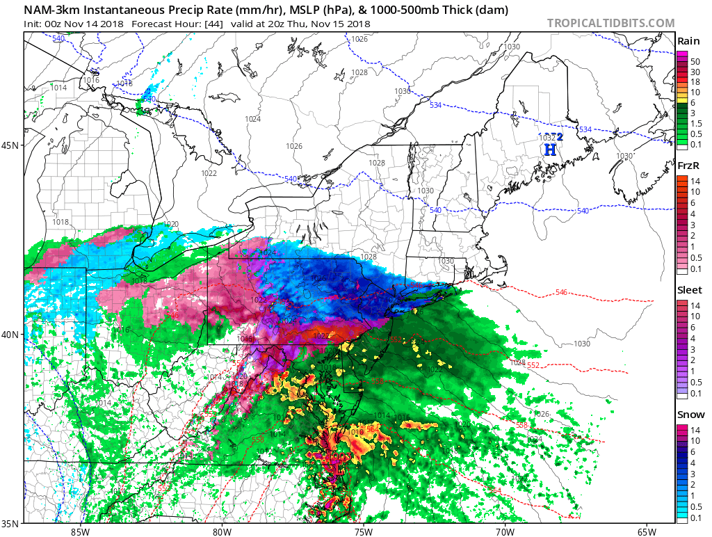
This morning, locations across Connecticut, New York, and New Jersey woke up to snow showers and freezing rain; the first of the season. Although hovering just above freezing for most of the morning in portions of the Metro Area, snow was still able to reach the ground before melting. In locations further to the north, up to an inch and a half of snow has been reported on the ground, with snow expected to continue in some locations until the early evening hours before fully transitioning to rain.

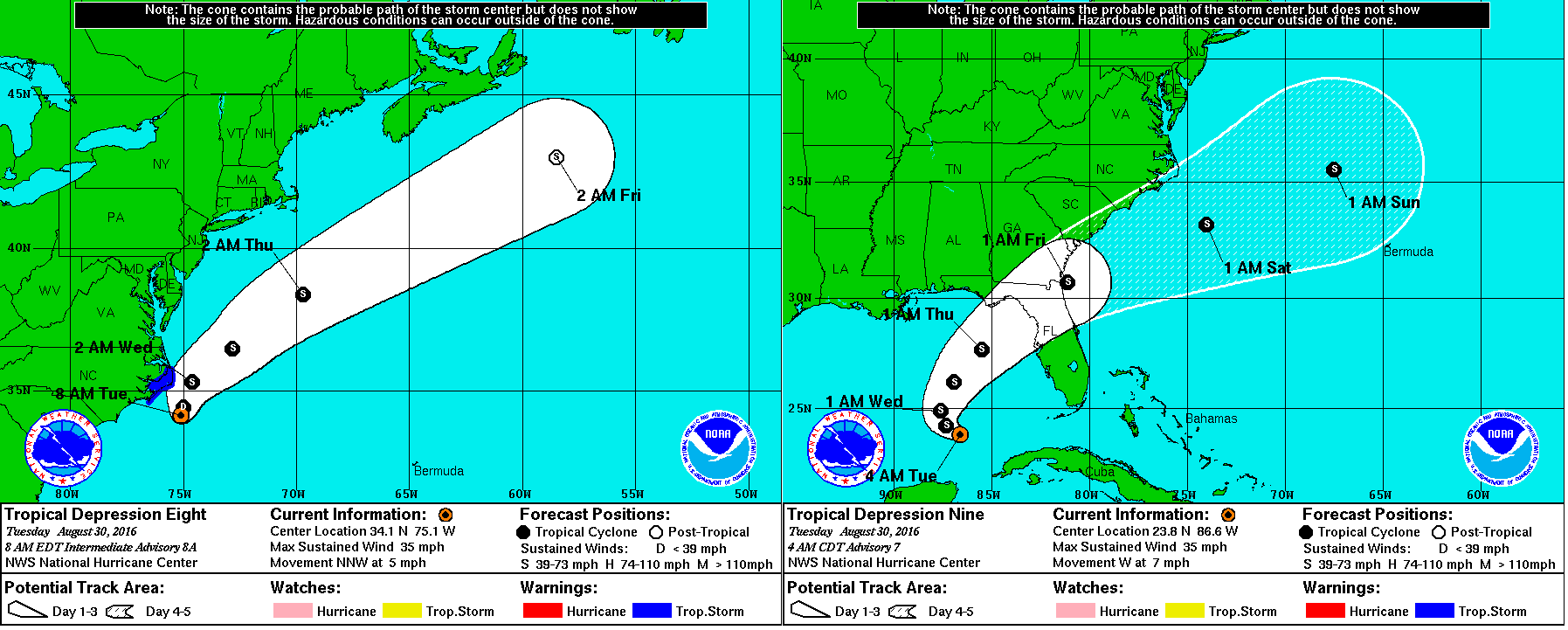
Tropical Depression 9, the swirling mass of clouds just to the north of The Yucatan in the image to the left, is expected to intensify into a Tropical Storm sometime over the next several hours. The warm waters of The Gulf combined with little shear has finally allowed this storm to grow rapidly over the past couple of days. The National Hurricane Center (NHC) has issued Hurricane Watches as well as Tropical Storm Warnings for much of the Big Bend area of Florida north of Tampa. Although the storm is not currently expected to become a hurricane before landfall, it will come close to doing so with sustained winds of about 65 MPH, so Hurricane Watches are still in effect for the area. Although a sort of model consensus has been reached regarding the short term for this storm, mayhem continues as some computer models have begun to indicate a shift to the west once it passes North Carolina. If this storm were to shift to the west as now indicated by some of the more trustworthy computer models, it would mean that impacts from this storm would be felt as far north as New England. As of now, The NHC has put a 50% chance of a 3 to 5 foot storm surge occurring in The Long Island Sound, but until the computer models receive more information, it is unlikely we will know the exact track. More updates will ne available here over the next several days, but please visit The National Hurricane Center at nhc.noaa.gov before making any decisions.

Tropical Depression 8 as well as Tropical Depression 9 are now expected to impact The US as Tropical Storms. Tropical Depression 8 is currently nearing The Outer Banks and is expected to strengthen to a Tropical Storm soon, prompting Tropical Storm Warnings for nearly the entire Outer Banks. Tropical Depression 9 has finished moving into the southeastern Gulf of Mexico as of this morning, and is expected to become a Tropical Storm over the next 48 hours as it begins its northeast turn towards Florida. After impacting portions of northwestern Florida, the storm is expected to reemerge over The Atlantic and continue to head to the northeast. Recently, some computer models such as The JMA (Based in Japan), The CMC (Based in Canada, as well as The UKMET (Based in The UK), have suggested a turn to the north and northwest, towards the coast of The Mid-Atlantic. There is no cause for concern quite yet for those in and around NYC, but Weather 360 will continue to monitor the situation.
I guess it’s that time of year again…
Due to atmospheric instability over the next following days, severe weather will pop up (mainly in the afternoons), across the Metro Area. This type of constant instability is not entirely common in the Northeast, as it only occurs when all the ingredients come together during the day (i.e. lifting parcels of moist air as well as a ‘trigger’ of sorts to jump start the storms), but due to a build up of heat and moisture, even winds coming off the Sound can create thunderstorms. Over the past several days, intense lightning storms have made night into day for certain portions of the Tri-State, and it was only several days ago when The National Weather Service confirmed a weak tornado touched down in North Haven, Connecticut.
The primary threat from these ‘pop-up storms’ is flash flooding and lightning, although it would be inadvisable to disregard this threat as nothing, as hail, high winds, as well as the potential for some isolated spin-ups does exist throughout the week.
Remember to stay alert and aware of all current threats and alerts, and make sure you alter your plans accordingly if thunderstorms are in the forecast.
Starting this afternoon, the potential for Severe Weather exists across the New York City Metropolitan Area. The first storms will begin to appear over the western portions of the Metro Area in the early afternoon, before becoming more numerous and greater in size by the early evening. At the moment, it is beginning to appear that there will be at least one line of storms that will form over The Hudson Valley around 3:00-5:00 PM EST.
It will be important to note that Weather360 is increasing the threat for Severe Weather today to 60% across the Metro Area, with the threat for isolated spin-ups and tornadoes at 22%. The primary threat today will be the threat for small hail, high winds, frequent lightning, and heavy rain. It is advisable to keep a weather radio nearby and to keep a lookout for storms in your area.
For more information, visit our YouTube Channel here, and in the event of an emergency, be sure to heed all advice distributed and issued by The National Weather Service.
Following a round of moderate to heavy rain this morning in and around New York City is the potential for severe thunderstorms in the mid afternoon. With the next round of storms expected to impact the area comes the threat of hail, high winds, heavy rain, and lightning (not ruling out the potential for an isolated tornado or two). In order to stay safe, take appropriate action now if you live in the NYC Metro Area. Make sure that you have a flashlight, water, and a weather radio available in the event of an emergency.
An important factor in forecasting severe weather is the Convective Available Potential Energy or CAPE value. The CAPE is a measure related to the total energy available for convection and the maximum vertical updraft speed. It is important to note that the greater the CAPE, the more likely it is for severe thunderstorm development. It becomes much more common for severe thunderstorms to develop in and around the NYC area when the CAPE value is above 800, give or take a few, and as of now, the SREF ensemble computer models (run by the Storm Prediction Center)are suggesting a CAPE value of around 1,200. Along with this, more short range computer models such as the HRRR are suggesting a line of thunderstorms popping up around 4:00 PM EST today across the area. Remember to be on the look out for severe weather today and heed any and all advice distributed by the National Weather Service.
The National Weather Service has issued multiple Severe Thunderstorm Warnings for the New York City Metro Area. This comes after a day of pouring rain that has saturated the ground. These storms will impact the area over the following several hours and may bring wind gusts of upwards of 60 mph along with lightning and some hail. Weather 360 advises to heed all warnings and to go inside if not already to avoid potential injury.
After a two month developing phase, Weather360 is back up and running even better than ever. Over the following weeks, a new Severe Weather Forecasting System will be implemented to give specialized information regarding the New York City Metro Area. Along with this, we plan to provide more insight into oncoming storm systems that may impact the Metro Area as well as large storm systems that may deliver severe outbreaks across the country.
This is the Third Edition of the NYC Area Week Outlook by Weather360
Monday: A wintry mix in the morning will transition to all rain by the afternoon. Total snow accumulations of up to a couple of inches are possible in some (mainly northern and eastern) portions of the area. Highs will hover around in the low to mid 40’s.
Tuesday: Highs dropping into the low to mid 30’s will be associated with clearing skies, making it seem much more like January than April.
Wednesday: High temperatures will peak in the mid 40’s as skies become increasingly cloudy, due to an incoming low pressure system.
Thursday: Rain associated with a low pressure system moving in from the west will bring in much more seasonable temperatures, with a high in the upper 50’s. This rain could spell the end to winter for many Ski Resorts throughout the Northeast.
Friday: Cooler temperatures along with clearing skies will make for a somewhat more seasonable day.
The Weekend: Highs in the 40’s along with mainly clear skies will make for a brisk, cool, early spring weekend.
In the event of an emergency weather situation, please consult the NWS at weather.gov and/or your local Emergency Management Office.
