Peak Activity: The Tropical Atlantic Heats Up

September 19, 2019 – Category 1 Hurricane Jerry is the latest addition to the National Hurricane Center Tropical Weather Outlook this evening. The 90 mph storm is moving to the west-northwest and threatens the Leeward Islands, where Tropical Storm Watches are currently in effect, as well as Bermuda, which is still experiencing rough waters from the once Major Hurricane Humberto.
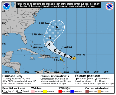
Hurricane Jerry 9 19 19.png
Hurricane Jerry, a relatively small storm as of the evening of September 19, poses a threat for the northern Leeward Islands as well as Bermuda over the next seven days.

Further to the west, the remnants of Tropical Storm Imelda continues to wreak havoc in Texas – where upwards of 40″ of rain have now fallen to the east of Houston. Large swaths of southeastern Texas, which were also slammed by the historic rainfall from Hurricane Harvey in 2017, are under Flash Flood and Flood Warnings.

The Rest of the Atlantic

  • Now Category 2 Hurricane Humberto continues to move to the north and east away from Bermuda with winds in excess of 105 mph.
  • Two areas with low probability of development over the next five days are moving into and through the Caribbean Sea.
  • A disturbance moving off the Africa has a 50% chance at developing into a Tropical Depression over the next five days. The most immediate effects of this potential storm could be felt in the Cape Verde islands.

For more information regarding the impacts of Imelda, please visit http://www.weather.gov. For more information regarding the progress of Hurricanes Jerry and Humberto, as well as the three noted areas of potential development, please visit http://www.nhc.noaa.gov.

More updates both here and on our Facebook page as conditions warrant.

Stay safe!

Hurricane Dorian: What You Need to Know

Category 4 Major Hurricane Dorian is barreling towards the US East Coast.  The storm, which has rapidly intensified over the past several hours, is expected to reach the Bahamas by Sunday afternoon.

What you need to know:

The Saffir-Simpson Scale:
Category 5: 157+ mph - Catastrophic Damage
Category 4: 130-156 mph - Catastrophic Damage
Category 3: 111 - 129 mph - Devastating Damage
Category 2: 96 - 110 mph - Extensive Damage
Category 1: 74 - 95 mph - Some Damage

As of the evening of August 30, 2019, Hurricane Dorian is a category 4 major hurricane with sustained winds of 130 mph and a central pressure of 950 millibars.

The current National Hurricane Center forecast cone keeps Florida in the cross-hairs. This afternoon, computer model guidance shifted the projected storm path eastward, placing locations from Miami to as far north as South Carolina under the threat of winds well in excess of 100 mph, excessive rainfall, and significant storm surge.

NHC Hurricane Dorian.png
The National Hurricane Center’s official track guidance as of 8 PM EDT on August 30, 2019. Hurricane Warnings (red) and Hurricane Watches (pink) have been issued for the Bahamas. This graphic depicts the potential storm center paths – not the potential extent of storm impacts.

The 8 PM EDT update from the National Hurricane Center has a category 4 storm making landfall near Port Saint Lucie, Florida. While there continues to exist uncertainty in the track of this storm, should this occur, storm surge well in excess of 7-11+ feet is possible on the coast of central eastern Florida, with top sustained winds potentially exceeding 130 – 140 mph in a radius reaching tens of miles from the center of the storm.

Who in the United States mainland will bear the brunt of this storm is still unknown. The storm will make a turn northward as it is picked up by a ridge of high pressure situated over the western Atlantic. When this storm makes its turn northward is still uncertain. 

It is vital that everyone on the US East Coast from Miami to South Carolina – and even further north – be prepared to act quickly ahead of this storm. 

Please prepare now and stay updated on local guidance and evacuation information from the National Hurricane Center (nhc.noaa.gov), the National Weather Service (weather.gov), and your local emergency management office.

Weather360 will continue to keep you updated on the progress of this storm both here and on our Facebook page.

Be prepared and stay safe!

2019 Hurricane Season Outlook

Colorado State University has recently released its 2019 Hurricane Season Outlook and is calling for a slightly below average hurricane season. The Colorado State University outlook for the Atlantic Hurricane Season has long been one of the staples used in the long-term forecasting of how violent or active a particular hurricane season will be.

This year, the CSU forecast (as of April) is calling for an expected total of 13 named tropical cyclones (the average is 12), 5 hurricanes (the average is 6), and 2 major hurricanes (the average is 3). This forecast is based on various points of data, including recent measurements indicating that the Tropical Atlantic is slightly cooler than average for this time of year. Check out the full report here.

CANSIPS shear estimate

CANSIPS shear estimate 2
Above are computer model forecasts, made available by TropicalTidbits.com, for this coming hurricane season. This particular model, the CanSIPS, is forecasting increased areas of wind shear (generally less favorable for hurricane development) across the lower Caribbean from August to November. This by does not rule out the presence or development of hurricanes or other cyclones in the Caribbean Sea.

The Atlantic Hurricane Season begins on June 1 and lasts until November 30, during which time, as with any year, there will most likely be several potentially life-threatening cyclones in the basin. Despite the slightly reduced risk for tropical cyclones, please remain vigilant throughout the late spring, summer, and fall for further developments.

If you live in an area prone to hurricanes or tropical storms, now is the best time to get prepared. Ensure you have a proper emergency supplies kit and other essentials by visiting https://www.ready.gov.

Stay safe!


Invest 99L Poses Threat to US Mainland

Invest 99L is an area of disturbed weather and thunderstorms currently moving west-northwestward at about 20 mph just east of the Leeward Islands. The storm has already defied some expectations that further organization would stall until the area of low pressure moved closer to Hispaniola, and has prompted an Air Force Reserve Hurricane Hunter aircraft trip into the storm later this morning. In the short term, a bit of a model consensus has been reached in terms of whether will the storm go north or south of Hispaniola, and over the past several days, more and more computer models have moved their tracks further to the north of the cyclone-killing mountains in Haiti and The Dominican Republic. The most likely storm track is as follows;  the storm will likely go north of Hispaniola and into the Bahamas before either being pulled north, or continuing on a track west over Florida (Sorry for the uncertainty, it’s still a bit early…) The most likely tracks do have one thing in common beyond the short term track though; most suggest landfall of at least a Tropical Depression somewhere on the East Coast of The United States. Whether the storm traverses Florida and makes another landfall somewhere in the Gulf before being pulled back into The Atlantic, or whether the storm moves up The East Coast, The United States will likely be impacted in some way, shape, or form by what is now Invest 99L.  It is important for those on The East Coast of The United States as well as those on the west coast of Florida to monitor the situation as it progresses and to stay tuned to updates from the National Hurricane Center.

Here's a look at The Tropical Atlantic Basin Satellite Imagery. 
Tropical Depression Fiona is north of The Leeward Islands, 
Invest 99L is east of the Leeward Islands,
And Tropical Storm Gastone is just west of The Cape Verde Islands.

More detail regarding Computer Model variations and outcomes can be found at our Hurricane Center page, where Weather360 is currently covering Invest 99L, Tropical Storm Gastone, as well as Tropical Depression Fiona in The Atlantic.

Pop-Up Severe Weather Expected Through the Weekend

I guess it’s that time of year again…

Due to atmospheric instability over the next following days, severe weather will pop up (mainly in the afternoons), across the Metro Area.  This type of constant instability is not entirely common in the Northeast, as it only occurs when all the ingredients come together during the day (i.e. lifting parcels of moist air as well as a ‘trigger’ of sorts to jump start the storms), but due to a build up of heat and moisture, even winds coming off the Sound can create thunderstorms. Over the past several days, intense lightning storms have made night into day for certain portions of the Tri-State, and it was only several days ago when The National Weather Service confirmed a weak tornado touched down in North Haven, Connecticut.

The primary threat from these ‘pop-up storms’ is flash flooding and lightning, although it would be inadvisable to disregard this threat as nothing, as hail, high winds, as well as the potential for some isolated spin-ups does exist throughout the week.

Remember to stay alert and aware of all current threats and alerts, and make sure you alter your plans accordingly if thunderstorms are in the forecast.


Rounds of Storms Firing Up in NYC Metro Area

Thought it was over? Well, guess again…

Over the past hour and a half, a line of thunderstorms brought periods of heavy rain, gusty winds, and lightning to mostly northern portions of the Tri-State Area.  Although this line of storms may have cooled things down a bit, there is yet another, larger line of thunderstorms that has the potential to bring even more severe weather to the Metro Area later on in the evening.  With respect to the first line of storms, although they may not have gotten their act quite together when it comes to supercell development, they still packed a punch able to take down large branches, leaves, and lower visibility to less than a mile in some locations temporarily.

The line of storms that is expected to move into the Metro Area tonight will have even more ingredients necessary for Severe Weather Development in their favor.  After the first line of storms earlier, the Mixed Layered CAPE, instead of dropping off, skyrocketed from 700-1,100 joules per kilogram, to 1,500-2,000 joules per kilogram.  Along with this, there has been a notable increase in Effective Helicity as well as Effective Shear, indicating that stronger and more developed storms are on the way.

The most important thing to remember today is that the storms are not over, and that it will be important to have access to NOAA Weather Alerts via an NOAA Weather Alerts Radio or via Cellular Phone so you can stay informed if Severe Weather hits.