2019 Hurricane Season Outlook

Colorado State University has recently released its 2019 Hurricane Season Outlook and is calling for a slightly below average hurricane season. The Colorado State University outlook for the Atlantic Hurricane Season has long been one of the staples used in the long-term forecasting of how violent or active a particular hurricane season will be.

This year, the CSU forecast (as of April) is calling for an expected total of 13 named tropical cyclones (the average is 12), 5 hurricanes (the average is 6), and 2 major hurricanes (the average is 3). This forecast is based on various points of data, including recent measurements indicating that the Tropical Atlantic is slightly cooler than average for this time of year. Check out the full report here.

CANSIPS shear estimate

CANSIPS shear estimate 2
Above are computer model forecasts, made available by TropicalTidbits.com, for this coming hurricane season. This particular model, the CanSIPS, is forecasting increased areas of wind shear (generally less favorable for hurricane development) across the lower Caribbean from August to November. This by does not rule out the presence or development of hurricanes or other cyclones in the Caribbean Sea.

The Atlantic Hurricane Season begins on June 1 and lasts until November 30, during which time, as with any year, there will most likely be several potentially life-threatening cyclones in the basin. Despite the slightly reduced risk for tropical cyclones, please remain vigilant throughout the late spring, summer, and fall for further developments.

If you live in an area prone to hurricanes or tropical storms, now is the best time to get prepared. Ensure you have a proper emergency supplies kit and other essentials by visiting https://www.ready.gov.

Stay safe!


Hybrid Storm Takes Aim on Northeast

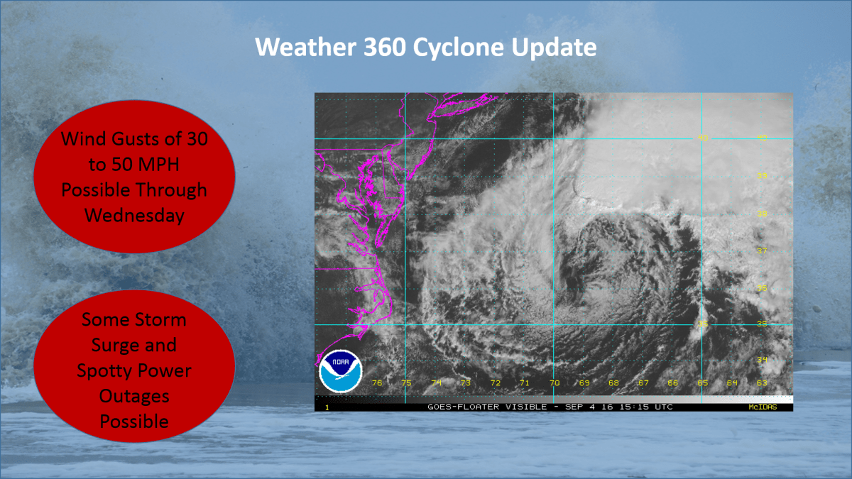
Tropical Storm Philippe has merged with a cold front off the coast of Delaware. The new center of low pressure is rapidly intensifying and continuing to push tropical moisture northwards. The core of the storm, as forecasted by nearly all computer models over the past 24 hours, is developing rapidly and, once onshore, is expected to bring with it wind gusts that could reach hurricane force. Today also happens to be the five year anniversary of the landfall of Hurricane Sandy, and the six year anniversary of the Halloween Snowstorm of 2011. This storm, although not as strong as either of these two infamous events, shares multiple, peculiar characteristics with both storms, including but not limited to the ‘negative dip’ in the jet stream, an atmospheric condition responsible for Sandy’s ‘sharp left turn’ into the Mid-Atlantic, as well as its combining with another storm system to create a hybrid-superstorm.

Hybrid Storm 10 29 17 625 PM Radar Image.gif
Northeast US Radar as of 6:25 PM Eastern Time.

The National Weather Service has issued a high wind warning for the entire NYC Metro Area, meaning that high winds will likely cause widespread power outages and will cause fallen items to block roadways. A flood warning is also in effect for the area, meaning that conditions are favorable for roadways and other low-lying locations to flood due to the excessive amount of rainfall. If travel is necessary, exercise extreme caution going into tonight and into tomorrow.

For more information, visit The National Weather Service at www.weather.gov.


Florida and The East Coast are Bracing for Hurricane Hermine

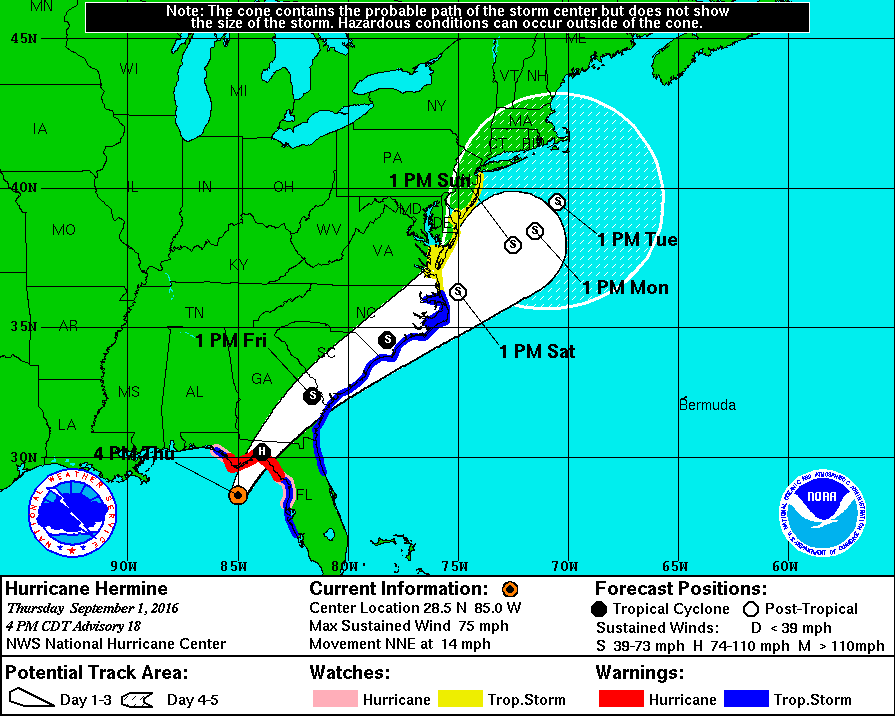
Hurricane Hermine will make history tonight as it will be the first storm of its status to make landfall in Florida in over a decade. Over the past week, what is now Hurricane Hermine went from being an area of exposed low-level circulation to what is now an organized storm capable of producing winds of 75 MPH as well as a storm surge of up to 8 feet on the coast. After impacting Florida tonight, the storm is expected to skirt the Southeast coast with winds exceeding 50 MPH before  moving out over the waters off the Mid Atlantic coast. The following is an image from The NHC displaying the expected track of Hermine as well as current watches and warnings.

nhc hermine hurricane track 9116.gif
This image is provided by The National Hurricane Center in Miami, Florida. Tropical Storm Watches and Warnings on The East Coast stretch from Florida to the NJ/NY border. On The Gulf Coast, Hurricane Warnings are still in effect for The Big Bend region of Florida, and Tropical Storm Warnings remain in effect for areas on The Panhandle as well as areas around Tampa.

This storm poses a serious threat to both life and property and has the potential to affect millions across The East Coast. Please consult the National Weather Service at weather.gov for your local watches, warnings, and advisories.

Remnants of Erika may redevelop, Tropical Storm Fred forms, Hurricane Ignacio may impact Hawaii

End of August Weather Overview: 2 PM EDT/AST, 8 AM HST August 30th 2015

Erika Redevelopment Recap

Over the past several days the weather world has been keeping a close eye on Erika, just about until yesterday, when it became a remnant low off the northern coast of Cuba.  After that point at 9:30 yesterday, almost all hope was lost for the redevelopment of Erika, but according to some short range computer models, the remnants moving northward across Central Florida, may redevelop a center of circulation soon off the Southeastern Coast.  So we’ll keep a close watch on this system over the upcoming several days.

Tropical Storm Fred Overview

Tropical Storm Fred formed yesterday off the coast of the Cape Verde Islands and is expected to become a hurricane while moving further northwest towards the central Atlantic.  Fred will thereafter weaken to a Tropical Storm once more and move quite quickly through the central Atlantic, the eventual destination is still at this point unknown.

Hawaii Hurricane Threat

Hurricane Ignacio is now a Category Four storm with winds upwards of 140 MPH, this storm is barreling to the northwest and is expected to graze the northern sides of the islands of Maui and the Big Island.  At the moment, Tropical Storm Watches are in effect for locations within The Big Island and all of Maui County.  For those with interests in the islands potentially affected by the storm, please continue to monitor the progress of this storm over the upcoming few days.

Weather 360 will continue to keep you updated on all of these threats over the coming days.

Tropical Storm Guillermo forms and is expected to cross paths with Hawaii

AS OF NOON JULY 30 EDT:

The National Hurricane Center has recently  upgraded former Invest 91-E to Tropical Storm status.  This newly formed Tropical Storm is expected to become a hurricane over the next day or two in the Eastern Pacific.  At the moment, nearly all the major spaghetti computer models are pointing at impact with Hawaii somewhere in between eary morning August 4 Hawaii Time, to somewhere around midday August 6 Hawaii Time.

The intensity computer models are not so sure though on the exact strength of this storm at the time of contact with Hawaii.  A few computer models suggest a potential Category 3 storm with winds surpassing 115 MPH.  And a few suggest a strong Tropical Storm with winds of about 60 MPH.  With all the current information we have, Weather 360 can start to assume that at the time of impact (which is still not 100%), Guillermo may be somewhere around the mid to high  Category 1 area, wth winds of around 80 MPH.  At the moment the NHC has forecasted winds the day before potential impact to be around 65 MPH.

Remember though, at any time all forecasts could shift tremendously, so nothing is ever 100% sure in the world of weather forecasting, especially when it comes to the longer range ones.

We will continue to keep everyone updated on the newly formed Tropical Storm Guillermo.

Heavy rain and thunderstorms sweeping across the country come closer to the Atlantic

As of 00 UTC, 8 PM EDT:  Thunderstorms moving to the southeast from western portions of Virginia are maintaining enough strength to produce storms capable of damaging winds, hail, frequent lightning, and heavy rain as to classify them as severe. Thunderstorms developing in upper portions of the Midwest have the potential to produce tornadoes and more severe weather as night approaches, these thunderstorms are all moving to the east-southeast.

The Tropics:  Newly formed Tropical Storm Claudette has maximum sustained winds of about 50 MPH and is moving to the Northeast off of the Mid Atlantic coast to the southeast of Nantucket.  The storm is expected to make landfall near Nova Scotia as a Tropical Depression with some winds and rains, along with rip currents.

Tomorrow’s forecast: Thunderstorms developing in the Midwest will have moved far enough east to begin to affect locations in and around NYC and other locations along the  I-95 Corridor.  With a high temperature hovering around the mid 80’s and clouds moving in early on in the day, the heat index is likely to be lower than that of yesterday, meaning that temperatures will not feel as hot as they did earlier today.  Later on tomorrow, more showers will start to move in and the potential for thunderstorms, some occasionally severe, increases.

For more information on weather across the United States, the Tropics, and more, watch our latest YouTube video as the channel Weather 360, and to start the discussion, visit us and post on our Facebook page at https://www.facebook.com/weather360.net

TROPICAL STORM BILL MAKES LANDFALL NEAR GALVESTON

This morning the NHC classified an area of disturbed weather with winds of 60 MPH with a well defined center of circulation as the second Tropical Storm of the year and the second Tropical Storm to make landfall this year in the United States, Tropical Storm Bill.  Currently, areas from the Louisiana border with Texas to the Mexican border near Brownsville are receiving some storm surge and winds in excess of 60 MPH along with torrential rains moving ashore.  The   NHC has issued Tropical Storm Warnings for the majority of the Texan eastern coast.  Several computer models are hinting (if not all of them) at the possibility of this storm maintaining at the very least Tropical Depression status several hundred miles inland, possibly to areas as far from the coast as Illinois or Indiana.  This storm is also bringing torrential rains to traverse the country as an abundance of tropical moisture comes through via Tropical Storm Bill. So, over the following days, rain will continue to spread over hard hit areas by flooding just about a week and a half ago, potentially bringing back severe flooding to areas susceptible to flooding.

For anyone in areas that are on the coast in Texas that will be impacted by Tropical Storm Bill, remain indoors unless absolutely necessary, and if you just go outdoors, exercise extreme caution and heed all warnings set out by the NHC.

Stay safe!

TROPICAL STORM ANA MAKES LANDFALL IN SOUTH/NORTH CAROLINA

The 50 MPH Tropical Storm Ana has just made landfall in South/North Carolina, bringing with it, rain, thunderstorms, and some storm surge.  Tropical Storm Ana is the first storm of the Atlantic Hurricane Season, and is also one of the earliest landfalls by a Tropical Cyclone on record. With Hurricane Season starting in over 20 days, some are now wondering how severe this upcoming season will be now… (this information can be found here at Weather 360.)

Where is Ana heading now?

083430W5_NL_sm(NHC prediction cone from earlier this morning.)

Where is Ana heading now?  Well, according to this NHC prediction cone, Ana is making landfall right now in South/North Carolina, (the border of), and will soon lose its Tropical Storm characteristics, but will remain as a Tropical Depression (Ana) with winds of about 30 MPH up until impacting southern New England and Long Island with some waves and some wind (and some rain.)

Weather 360 will keep you posted, stay safe!

Where’s soon-to-be Ana heading?

Have a look at our graphic, the red line on the coast means that imminent landfall is expected in the next two days.

Map of Ana 5 7 15 2019 PM EST UTC -4Map of Ana 5 7 15 2019 PM EST UTC -4

Our graphic shows Invest 90L, which will then likely be Ana, moving into the SC/NC coastline, but due to the current run of the European computer model, we are having this storm ride up the coast a bit further, then veering out to sea before having a chance to make landfall in New York and New England.

At the moment, the National Hurricane Center (NHC), is saying there is a 90% chance of development for this Invest 90L over the next 2 days.  Due to this storm being more associated with the Jet Stream, this storm will likely be first classified as a Sub-Tropical Storm, but don’t be fooled by the “Sub”, these storms are the equivalent of a regular Tropical Storm, and if they break free of whatever holds them back, can quickly strengthen.

For preparedness tips for this storm, consult the NHC or your local emergency management center to stay safe.

Stay safe and be prepared!