Strong Nor’easter to Develop Friday

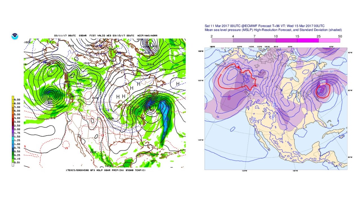
A strong Nor’easter is expected to develop from a center of low pressure that will move from the Midwest over the Mid Atlantic coast Thursday night. Strong winds and heavy precipitation will likely create power outages and hazardous travel on Friday.

NAM Radar Friday March 2 2018 Noon
NAM 3km computer model display of potential weather conditions at noon on Friday. (image from tropicaltidbits.com)

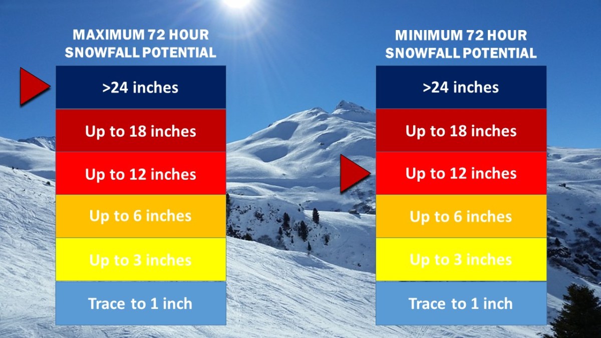
While it is certain that a Nor’easter will strengthen rapidly over the Mid Atlantic coast, the type of precipitation received in the NYC Metropolitan Area will depend on its proximity to the coast. As of this afternoon, the ECMWF (European) and the NAM (North American) computer models are forecasting enough cold air to transition the heavy precipitation into snow by 10 am or noon Friday. Snow totals in locations where the precipitation does change over to snow could see snow totals exceeding half a foot to over a foot of snow by Saturday morning.

Snow Accumulation 18-2
Weather 360 72 Hour Snow Total Forecast Graphic as of 4:00 PM ET 2/28/2018.


Blizzard Disrupts Travel As Paralyzing Cold Moves In

A significant winter storm has brought up to 12 inches or more of snow along with wind gusts exceeding 60 mph to the Northeast. Schools remain closed throughout southern New York, New Jersey, and Connecticut as wind speeds of 40 mph create wind chills approaching 25 below zero. The National Weather Service has issued wind chill advisories for the area warning of the potential for frostbite to occur within 30 minutes of exposure to the record-breaking low temperatures.

1 5 18 Temperatures NAM
Low temperatures are expected to approach 0 degrees throughout the area with wind chills reaching minus 20 by the morning.

Expect high winds to continue to create low visibility going into Friday afternoon with the potential for downed trees and tree limbs lasting until Sunday morning.

Hybrid Storm Takes Aim on Northeast

Tropical Storm Philippe has merged with a cold front off the coast of Delaware. The new center of low pressure is rapidly intensifying and continuing to push tropical moisture northwards. The core of the storm, as forecasted by nearly all computer models over the past 24 hours, is developing rapidly and, once onshore, is expected to bring with it wind gusts that could reach hurricane force. Today also happens to be the five year anniversary of the landfall of Hurricane Sandy, and the six year anniversary of the Halloween Snowstorm of 2011. This storm, although not as strong as either of these two infamous events, shares multiple, peculiar characteristics with both storms, including but not limited to the ‘negative dip’ in the jet stream, an atmospheric condition responsible for Sandy’s ‘sharp left turn’ into the Mid-Atlantic, as well as its combining with another storm system to create a hybrid-superstorm.

Hybrid Storm 10 29 17 625 PM Radar Image.gif
Northeast US Radar as of 6:25 PM Eastern Time.

The National Weather Service has issued a high wind warning for the entire NYC Metro Area, meaning that high winds will likely cause widespread power outages and will cause fallen items to block roadways. A flood warning is also in effect for the area, meaning that conditions are favorable for roadways and other low-lying locations to flood due to the excessive amount of rainfall. If travel is necessary, exercise extreme caution going into tonight and into tomorrow.

For more information, visit The National Weather Service at www.weather.gov.


Blizzard Warnings Issued, Massive Snow Accumulation Expected

The National Weather Service has extended Blizzard Warnings for more than half of the NYC Metropolitan Area. Expect high winds in excess of 40 to 60 mph, snow totals approaching 28″, and downed trees and power lines.

Snow Accumulation 14
Expect at least 12″ in most areas, and as much as 2′ in many areas by Wednesday.

This storm will likely be the largest blizzard in 2, or even 5 years. The proximity of this storm to the coast will mean high winds and heavy snow will make for whiteout conditions. If you do not have to, avoid travel. For more information, visit us here or on our Facebook page. To learn more about the dangers this storm poses, consult the NWS at weather.gov.

Crippling Blizzard Expected Tuesday

Winter Storm and Blizzard Watches remain in effect for locations across the NYC area. Weather 360 is now forecasting that up to 2′ of snow is possible in locations situated mainly to the west and the north of the city, and that at least 6″ of snow will accumulate even in the event the storm does not make a “direct” hit.

Snow Accumulation 12
Weather 360 72 Hour Snow Totals Forecasts update about every 6 hours ahead of storms. Currently, Weather 360 is calling for at least 6″, and at most up to 2′.

It is increasingly likely that blizzard conditions will be felt on Tuesday, as heavy wet snow combined with wind gusts approaching 45+ mph may make for white out conditions. Due to the wind and snow, expect power to go out in some areas and take appropriate precautions ahead of the storm. For more information regarding the dangers this storm poses, consult the NWS at weather.gov. We’ll continue to keep you updated on the progress of this storm both here, and on our Facebook page.

Major Winter Storm Prompts Alerts in NYC Area

Winter Storm and Blizzard Watches are in effect for the entire NYC area. The National Weather Service is currently calling for up to 18″ of snow in some locations, as more major computer models have continued to suggest a strong Nor’easter developing off the East Coast by Tuesday morning.

GFS ECMWF 3 11 17 3 15 17 BLIZZARD
The GFS and the ECMWF (Euro) computer models from this morning. In the most recent runs, both models have suggested an essentially identical storm that will come in close proximity to the Mid Atlantic/New England coast, putting it in an ideal position to dump massive amounts of precipitation on the area.

Weather 360 is estimating that maximum snow totals in the area may exceed 18″ should the storm remain close enough to the coast to bring its moisture inland, but far enough away to keep temperatures below the freezing line. Even in the event that the storm does not remain in the Nor’easter ‘Goldilocks Zone’, expect there to be at least 3-6″ of snow on the ground by Wednesday morning. For more information regarding the dangers this storm poses, consult the NWS at weather.gov. We will continue to post updates on the progress of this storm over the coming days both here, and on our Facebook page.