Snow has been falling for several hours in what may turn out to be 2019’s first significant nor’easter. Upwards of half a foot of snow is now expected throughout the entire New York City Metropolitan Area. Winter Storm Warnings are in effect.
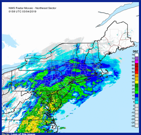
National Weather Service radar image from about 9pm Eastern Time March 3, 2019. This image does not distinguish between liquid and frozen precipitation.Weather 360’s final snow total forecast for this early March winter storm. The National Weather Service has issued Winter Storm Warnings calling for 4 to 8 inches of snow for many locations, especially those north of the city.
Over the past 24 hours, several computer models, such as the NAM3km and HDRPS (both detailed and accurate computer models) have zeroed in on this storm lasting from Sunday afternoon through Monday around 6 or 7 am ET. Both computer models have pointed to snow totals averaging about 5 to 9 inches in Manhattan, Long Island, New Jersey, the Lower Hudson Valley, and southern Connecticut.
Weather 360 is forecasting roadways of all types, especially secondary and tertiary roadways, to become dangerous tonight into early tomorrow morning. Please exercise extreme caution while driving during the duration of this event.
While snow has been falling for some time now, roadways are only now beginning to become covered and particularly hazardous in some places. Other than up to several inches of snow on roadways by tomorrow morning, it is possible that because of warmer temperatures earlier Sunday, there may be small layers of ice beneath the snow. Although temperatures will warm to above freezing on Monday, rapid refreezing Monday afternoon may create black ice on roadways.
Aside from several inches in November, it has been ten months since there has been significant snowfall seen in the New York City Metropolitan Area. This is now expected to change as soon as this weekend, as a significant winter weather event has begun to move east.
The evening run of the FV3 GFS computer model on January 16, 2019. Any slight shift to the east or south with this storm could mean extremely high snow totals closer to, or even south of, I-95. (Image courtesy tropicaltidbits.com)
Snow will quickly develop and intensify as it moves into the Tri-State Area late Saturday evening or early Sunday morning, bringing with it rapid accumulations on most surfaces. However, the position of the storm will dictate if and when many locations will see a changeover to sleet, ice, or rain.
At the moment, it appears that locations north of the city and I-95 will experience this transition as early as 9 am Sunday, allowing for potentially significant ice accretions on many surfaces by noon Sunday.
Whether or not the precipitation remains frozen or becomes rain during the day, snow and ice will redevelop by the afternoon as temperatures drop and winds increase Sunday night. It is also important to note that, regardless of the direct impacts of the storm, temperatures will fall to near below zero throughout the Mid Atlantic and New England by early Monday morning. This rapid refreezing could mean any liquid precipitation that falls may become ice on roads, trees, and power lines quickly after the storm exits the area.
The evening run of the NAM 12km computer model on January 16, 2019. This particular run suggests a delayed transition from snow to ice or rain around NYC, meaning snow accumulations could run much higher than currently expected. (Image courtesy tropicaltidbits.com)
Due to the uncertain nature of the this storm, Weather 360 is currently forecasting anywhere between 4 and 12+ inches north of I-95, with anywhere between 3 and 8+ inches to its east and south. Forecasts will be refined in the coming days as the center of the storm develops, but for now, be prepared for a storm that could knock out power, make travel dangerous for an extended period of time, and dump a significant amount of snow, sleet, ice, and rain.
A developing nor’easter is promising to bring the season’s first significant snowfall to the NYC tri-state area later this week.
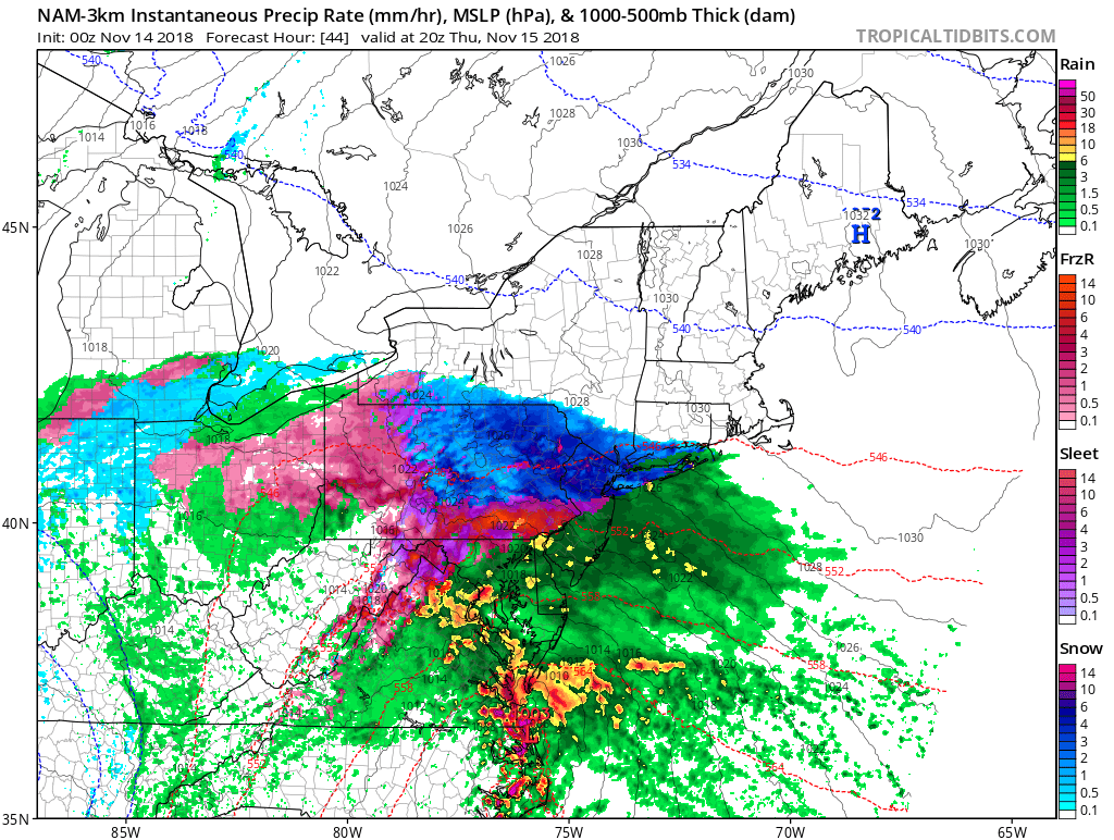
This is the first Weather 360 forecast made with the aid of a new forecasting algorithm tailored to the NYC Metro Area. Updated as of 8 pm ET Tuesday, November 13, 2018.
The heaviest snowfall will likely be around or after sunset Thursday with the potential for some light icing around midnight. Though while the storm system may bring upwards of half a foot of snow or more to some locations by late Thursday night or early Friday morning, due to the warm air brought by the proximity of the center of the storm to the coast, come the morning commute on Friday most of it will be more slush than snow.
The potential for heavy snow to develop quickly Thursday afternoon over the NYC Metro Area.
As with most winter weather events this early in the season, slight changes in track can mean the difference between freezing and above freezing and rain and snow. However, due to the possibility for snow to accumulate within minutes on some surfaces, travel may become hazardous from mid-afternoon Thursday through late morning Friday.
A strong Nor’easter is expected to develop from a center of low pressure that will move from the Midwest over the Mid Atlantic coast Thursday night. Strong winds and heavy precipitation will likely create power outages and hazardous travel on Friday.
NAM 3km computer model display of potential weather conditions at noon on Friday. (image from tropicaltidbits.com)
While it is certain that a Nor’easter will strengthen rapidly over the Mid Atlantic coast, the type of precipitation received in the NYC Metropolitan Area will depend on its proximity to the coast. As of this afternoon, the ECMWF (European) and the NAM (North American) computer models are forecasting enough cold air to transition the heavy precipitation into snow by 10 am or noon Friday. Snow totals in locations where the precipitation does change over to snow could see snow totals exceeding half a foot to over a foot of snow by Saturday morning.
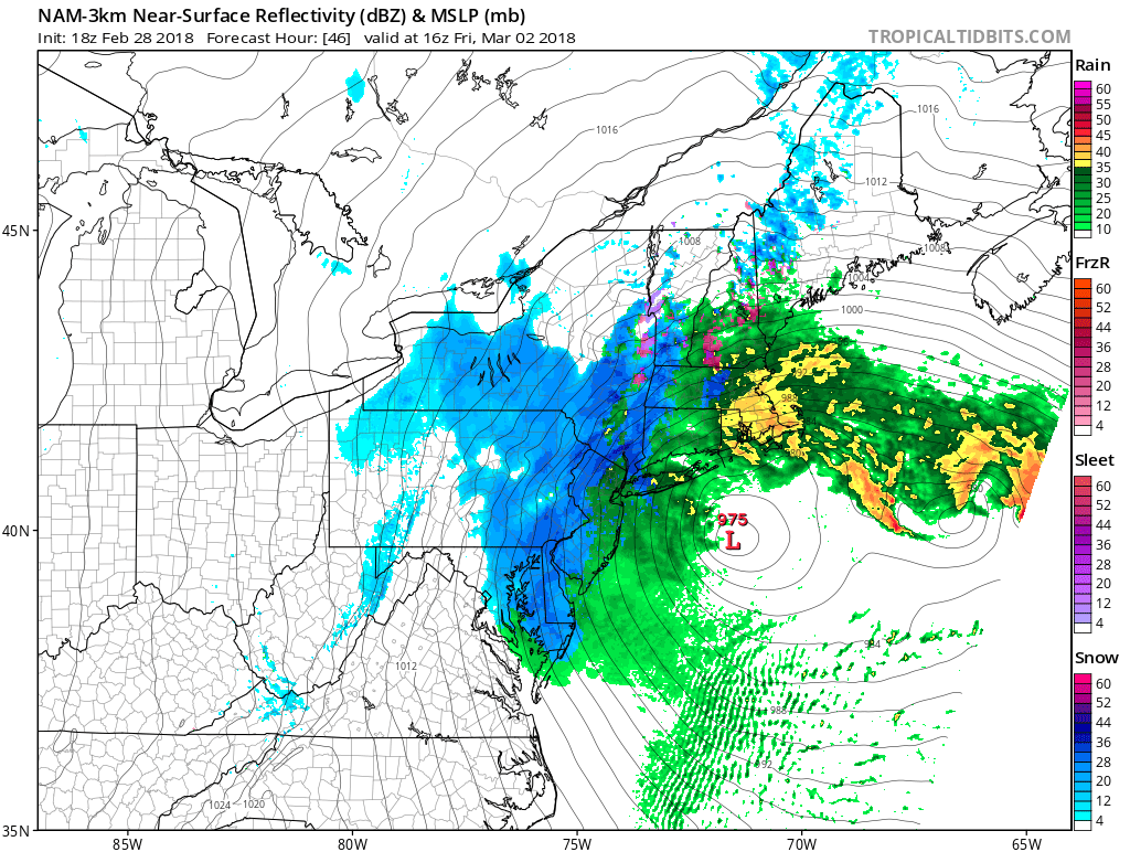
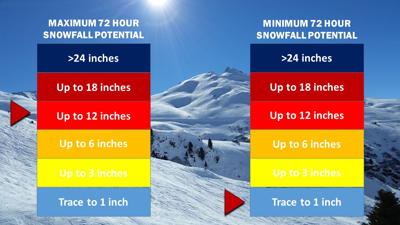
Weather 360 72 Hour Snow Total Forecast Graphic as of 4:00 PM ET 2/28/2018.
A low pressure system is forecasted to develop off the coast of Florida this Tuesday, at which point it has the possibility to come close enough to the coast to impact the Northeast by Thursday.
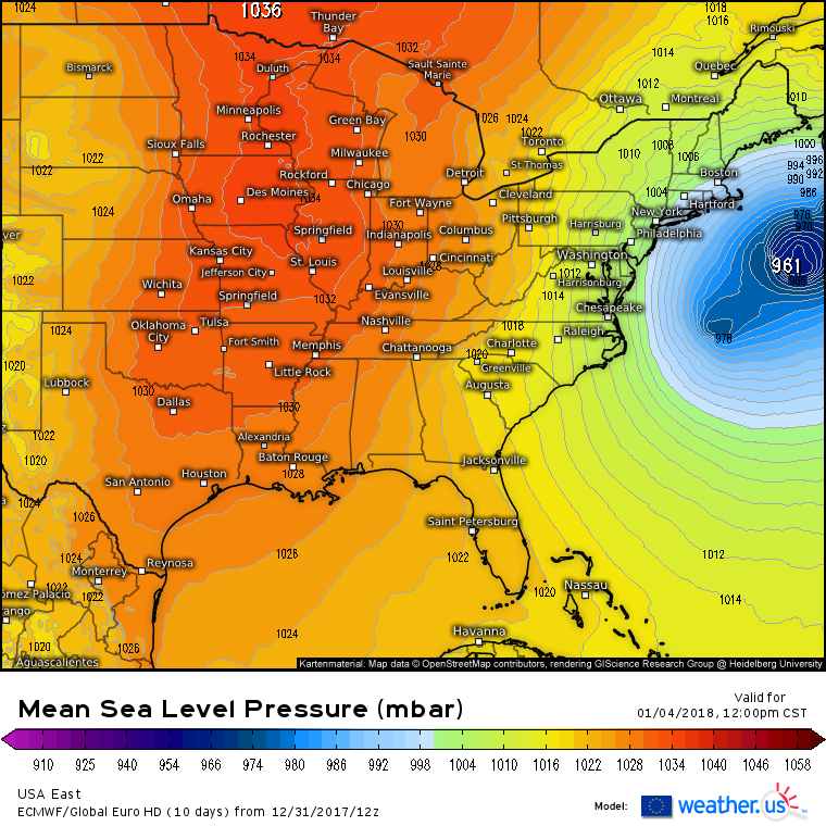
European Computer Model (ECMWF) run for Thursday, January 4, 2018, depicting a strong low pressure developing several hundred miles off the US East Coast. (Image courtesy of Weather.us)
As low temperatures correlate to higher yields of snow from the same amount of liquid precipitation, should the storm system track any closer to the coast, upwards of half a foot to a foot of snow or more could be possible. At this time it is still unknown as to whether or not the storm will come close enough to impact the NYC area, but the potential exists for a significant winter storm or blizzard come later this week.
A low pressure system currently located over the Southeast is on its way northeastward, and is expected to impact large swaths of the East Coast tonight into early tomorrow morning, prompting winter weather advisories for locations across southern Connecticut and New York, as well as in parts of New Jersey. Expect the snow to create slick conditions for the morning commute, as it will quickly stick to the ground and pavement.
Weather 360 is forecasting a maximum snow accumulation of about 3 inches in locations close to the coast, with a trace to an inch of snow further inland.
This is the Second Edition of the NYC Area Week Outlook by Weather360
Monday: Snow lingering in the morning will lead to sunnier and drier conditions in the afternoon with highs in the 40’s. Total snow accumulations of up to several inches are possible in some (mainly eastern) portions of the area.
Tuesday: Highs nearing 50 will be accompanied by much clearer conditions, making it seem much more like Late-March than Monday did.
Wednesday: Temperatures will finally break 60 degrees n most spots, so say ‘sayonara’ to any remaining snow mounds.
Thursday: Highs again in the 60’s will make it feel even more like spring, but the threat for showers does increase as the week progresses.
Friday: Highs again in the 60’s will also bring along some light to moderate rain showers. Only problem though is that its not April yet, so I guess these showers wont bring any May flowers…
The Weekend: Temperatures in the 50’s along with somewhat clear conditions are likely to remain the most significant weather factor over the weekend. Although, there is the potential for a Nor’easter to impact the area around Sunday, so it may not be to bad to have some rain gear nearby.
In the event of an emergency weather situation, please consult the NWS at weather.gov and/or your local Emergency Management Office.
Locations across the NYC Metro Area are now under Winter Weather Advisories as snow and other wintry precipitation continues to envelop the area. Tonight, temperatures will continue to rise, and the wintry precipitation now will slowly transition to sleet and freezing rain, before tapering off as some rain showers across the area very early tomorrow morning. Currently, areas still receiving snow will likely have accumulated 1-3 inches of snow by now, making it somewhat difficult to get around. Ground temperatures are still below that of the air, meaning that areas receiving snow or other wintry precipitation will likely continue to see more accumulation. Tomorrow’s commute will be messy in the early morning until more rain moves in around 9 AM to wash some of the slush and snow on the roads away.
A Winter Weather Advisory is issued when the National Weather Service decides there will be hazardous weather in a certain area that will include some sort of wintry precipitation.
Most Winter Weather Advisories across the area are set to expire tomorrow around 7 AM.
The first major winter storm for millions across the Northeast is on its way. This storm is expected to create blizzard conditions from Connecticut to Virginia and travel delays lasting hours or days from JFK to Reagan Natl.
*The National Weather Service in Upton New York has issued Winter Storm and Blizzard Watches for parts of the New York City Metropolitan Area. Locations in southern portions of Connecticut can expect alerts ranging from Winter Weather Advisories to Blizzard Warnings over the following 24 hours.*
*UPDATE*- The short range computer models are now in range of this storm and have continued to flip-flop on their positions over the past 18 hours. The NAM (12 KM) is now calling for the storm to ride further up the Eastern Seaboard and bring over two feet of snow to almost the entire NYC Metro Area. Other short range computer models such as the WRF-NMM, WRF-ARW, and the RGEM are slowly inching their forecasts further north. More shifting and settling with more northerly forecasts can be expected over the following day or so as the low pressure that will become this “Snowmageddon V.2” stays closer to the north end of all the previous tracks.
Specific and detailed updates for your area can be found on weather.gov