Wintry Mess Expected Tomorrow

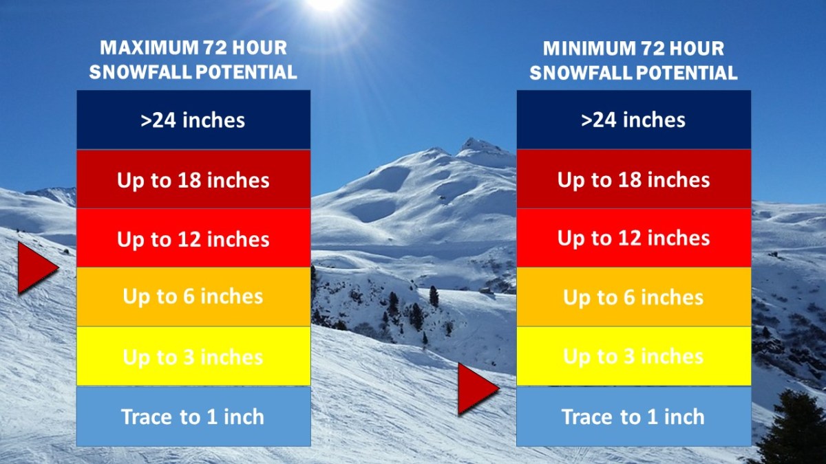
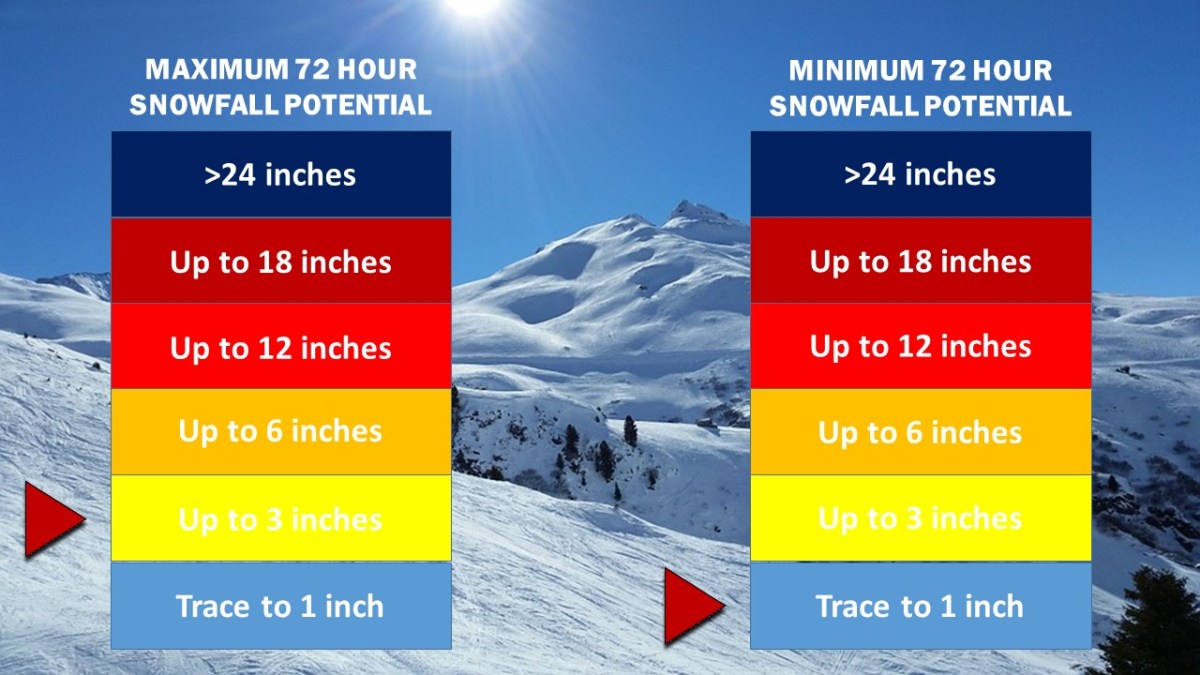
Only 2 days after the largest storm of the season, the Northeast is on the brink of yet another major winter weather event. In southern portions of the Mid-Atlantic and New England, snow in the morning will likely transition to a wintry mix or rain by the afternoon, but further to the north, cooler conditions will allow for up to 2 feet of snow to accumulate in some areas.

The most significant differences in snow accumulation are expected to occur between locations further to the south and closer to the coast, and those slightly further to the north and inland. In the NYC Metro Area, up to a foot of snow, sleet, as well as some ice is possible in locations to the north of Westchester, whereas in coastal NJ, NY, and CT, only a few inches of snow is expected before the transition to more liquidy precipitation takes place.

Regardless of accumulation, expect weather conditions tomorrow to reduce visibility and hamper travel all day. Please be aware of the weather conditions at your current location as well as in your destination if you intend to travel. More safety related information can be found at http://www.weather.gov.

Major Snowstorm to Remain Offshore

A significant snowstorm expected to bring blizzard conditions and up to a foot of snow to portions of Virginia and the Southeast may bring up to several inches across the Mid Atlantic and the Northeast, prompting winter storm warnings and winter weather advisories for portions of Long Island and eastern Connecticut. The National Weather Service also forecasts light snow accumulation for much of the Metro Area, with areas of Long Island receiving as much as 6 to 8 inches of snow by tomorrow night.

Weather 360 forecasts up to 4 inches of snow for much of southwestern Connecticut, and a half foot or more of snow for much of Long Island. As the snow will start around midday, travel in the afternoon may become slick and at times there may be periods of low visibility.

Snow Accumulation 3.jpg

Please consult The National Weather Service at weather.gov for more info.

Snow Expected Tonight, May Cause Messy Morning Commute

A low pressure system currently located over the Southeast is on its way northeastward, and is expected to impact large swaths of the East Coast tonight into early tomorrow morning, prompting winter weather advisories for locations across southern Connecticut and New York, as well as in parts of New Jersey. Expect the snow to create slick conditions for the morning commute, as it will quickly stick to the ground and pavement.

Weather 360 is forecasting a maximum snow accumulation of about 3 inches in locations close to the coast, with a trace to an inch of snow further inland.

snow-accumulation-2

NYC Weather: Rain, Milder Temperatures, and Snow This Week?

This is the First Edition of the NYC Area Week Outlook by Weather360

Monday: Rain moving across the area will be accompanied by cooler temperatures hovering in and around the 40’s.

Tuesday: Rain will taper off towards the late morning leading to cloudy conditions with highs maybe reaching the 50’s.

Wednesday:  Some showers with temperatures around the 60 degree mark will create a more spring-like feel again.

Thursday:  Some light rain showers will bring slightly cooler temperatures in the mid 50’s.

Friday: Clear skies are expected along with temperatures still in the mid 50’s.

Weekend:  Saturday will be much like Friday, but the potential for a significant Nor’easter exists starting Sunday, lasting into early next week.  This year, Punxsutawney Phil may actually end up being wrong, as cooler temperatures may create some wintry precipitation across the area, but nothing is set in stone quite yet.


In the event of an emergency weather situation, please consult the NWS at weather.gov and/or your local Emergency Management Office.