Major Winter Storm Tomorrow

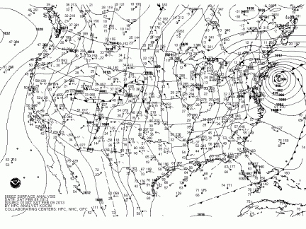
Winter Storm and Blizzard Warnings have been issued for the entire I-95 Corridor from New York to Boston. Exactly 4 years ago, Winter Storm Nemo created the exact same situation. Winter Storm Nemo, pictured below in an NOAA Surface Analysis, dumped 40 inches of snow in parts of Connecticut, and while tomorrow’s winter storm (named ‘Niko’) will likely dump no more than a foot and a half, it certainly is expected to resemble the historic storm that took place 4 years ago.

winter-storm-nemo-surface-analysis
Tomorrow marks the 4th anniversary of Winter Storm Nemo (above), and for the occasion, a nearly identical system is expected.

Expect high winds and heavy snow lasting from late tonight until tomorrow afternoon to greatly reduce visibility and knock down some tree limbs and power lines. Many schools across the area will likely be closed tomorrow, as the storm will also greatly reduce the ability to travel. Due to the remaining uncertainty in the storm’s intensity as it passes the area, Weather 360 is forecasting snow totals to vary from 6 inches in locations on the immediate coast, to as much as 16 inches for locations not much further inland.

 For information regarding watches, warnings, and advisories, visit weather.gov, and in the meantime, we’ll keep you posted.

BLIZZARD SHIFTS NORTH

January 23, 2016 Update:

THE TRACK FOR THIS BLIZZARD HAS SHIFTED NORTH.  LOCATIONS IN SOUTHERN CONNECTICUT ARE NOW UNDER BLIZZARD AND WINTER STORM WARNINGS.

In locations across the New York City Metro Area, the snow has already started to accumulate.  The National Weather Service is now calling for a foot or more in most of the Metro Area.  Expect an additional foot or more of snow with some brief bursts of thunder snow throughout the day starting at 7 am.

The storm has the potential to create extremely dangerous road conditions at times today even in areas not specified under Blizzard Warnings.

There is the potential for widespread power outages across the Tri-State area.

Before making any decisions regarding the weather.  Visit weather.gov.

Winter Storm and Blizzard Warnings Issued

A major winter storm is expected to impact the entire New York City Metro Area tonight into Sunday Morning.

Southern Connecticut Overview:  Currently, Southern Fairfield and Southern New Haven Counties are under Winter Storm Warnings.  Locations in southern portions of Northern Fairfield County can expect near-blizzard conditions, but due to less of a threat further north in the county, the National Weather Service has decided to keep the alert level at an advisory (likewise for Northern New Haven County).  Expect wind gusts around 40 MPH with snow totals 6-15 inches.

Southeastern New York Overview: Blizzard conditions for the Greater New York City area along with Long Island.  Winter Storm Warnings for locations just to the north (Westchester County), and continued Winter Storm Watches for locations just to the north of there.  Expect wind gusts potentially reaching 50 MPH with snow totals ranging from 6 to 18 inches.

Northern New Jersey Overview: Winter Storm Warnings issued for Northwestern portions of this area.  Blizzard Warnings closer to the coast.  Expect snow totals ranging from 6 to 24 inches with wind gusts potentially reaching 60 MPH.

For more detailed information, visit weather.gov

As of 1/22/2016 5:00 PM EST

Winter Storm Alert

THE NATIONAL WEATHER SERVICE IN UPTON NEW YORK HAS ISSUED BLIZZARD WARNINGS FOR ALL OF LONG ISLAND, PARTS OF NORTHERN NEW JERSEY, AND FOR THE GREATER NEW YORK CITY AREA.  WINTER STORM WATCHES AND WARNINGS HAVE BEEN ISSUED FROM SOUTHERN CONNECTICUT TO NORTHWESTERN PORTIONS OF NEW JERSEY.

For locations not in Blizzard Warnings, very near-blizzard conditions can be expected, with visibility less than 1/2 mile at times.  Power also has the potential to go out, as high wind gusts and heavy, wet snow can be expected for about 20 hours.

For more information, please visit weather.gov

“Snowmageddon v.2” Update

*UPDATE – 6:00 PM EST 1/21/2016*

The first major winter storm for millions across the Northeast is on its way.  This storm is expected to create blizzard conditions from Connecticut to Virginia and travel delays lasting hours or days from JFK to Reagan Natl.

*The National Weather Service in Upton New York has issued Winter Storm and Blizzard Watches for parts of the New York City Metropolitan Area. Locations in southern portions of Connecticut can expect alerts ranging from Winter Weather Advisories to Blizzard Warnings over the following 24 hours.*

*UPDATE*-  The short range computer models are now in range of this storm and have continued to flip-flop on their positions over the past 18 hours.  The NAM (12 KM) is now calling for the storm to ride further up the Eastern Seaboard and bring over two feet of snow to almost the entire NYC Metro Area.  Other short range computer models such as the WRF-NMM, WRF-ARW, and the RGEM are slowly inching their forecasts further north.  More shifting and settling with more northerly forecasts can be expected over the following day or so as the low pressure that will become this “Snowmageddon V.2” stays closer to the north end of all the previous tracks.

Specific and detailed updates for your area can be found on weather.gov