Far-Reaching Winter Storm Expected to Bring Heavy Snow, Sleet, Ice, and Rain

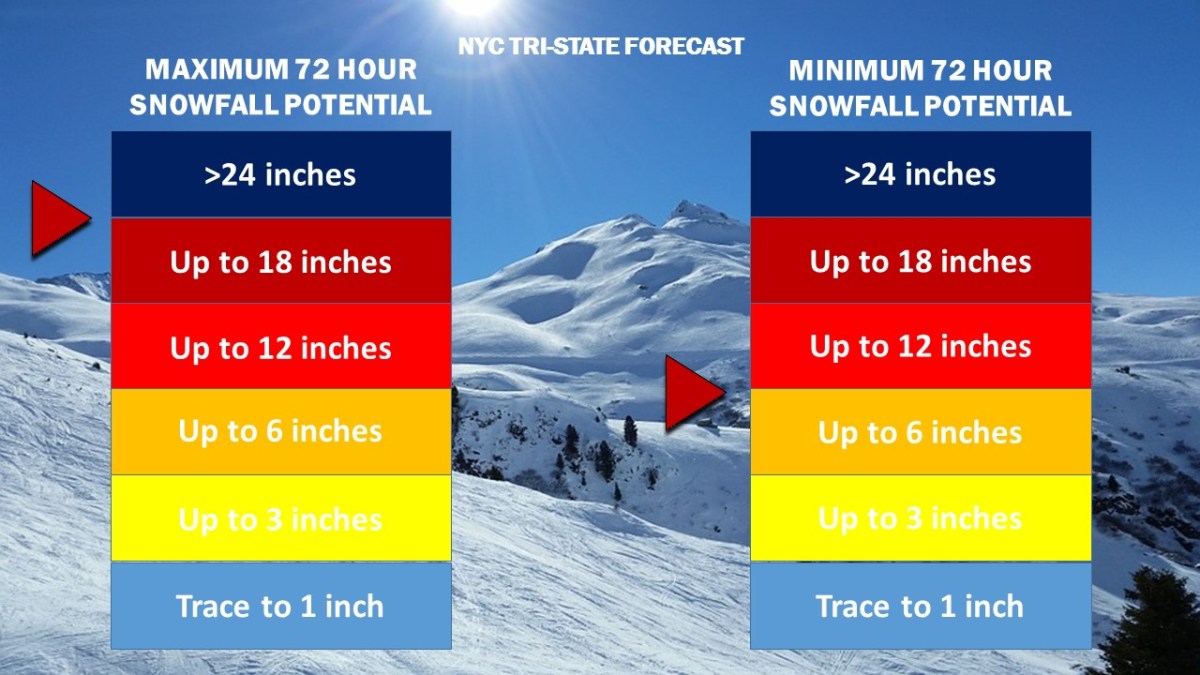
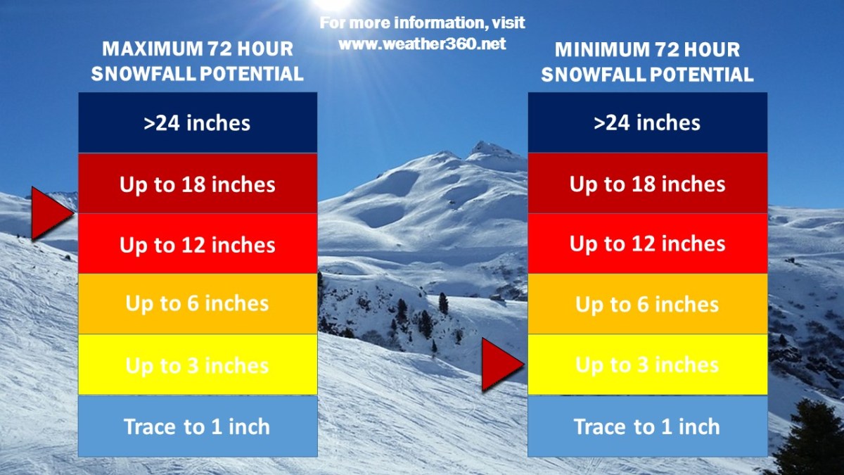
2019’s first major winter weather event has now triggered Winter Storm Warnings throughout the NYC Metropolitan Area. Recent runs of short range computer models have indicated larger-than-expected snow accumulations north and west of the city, with some places potentially receiving upwards of 12 inches of snow along with up to a quarter of an inch of ice.

snow accumulation 19 - 1 18
The official Weather 360 Tri-State-wide snow total forecast as of 6:00 pm ET January 18, 2019. As per usual in storms involving ice and wintry mix, the greatest snow totals are most likely to occur in interior locations of New York, New Jersey, and Connecticut to the north and west of the city.

While more areas may see more snow than ice or rain, the potential still exists for upwards of a quarter of an inch of ice to accumulate by early Sunday morning. The threat of ice, along with heavy snow and wind gusts potentially exceeding 50 mph, may lead to downed trees and tree limbs as well as power outages come Sunday afternoon. Coupled with sub-zero temperatures Sunday night, the storm has become potentially serious, especially for those who do experience lapses in electricity.

4 Dangerous.JPG
The official Weather 360 roadway forecast, valid from sundown Saturday afternoon until Monday morning. Exact roadway conditions will be heavily dependent on location, but expect conditions to be especially hazardous during the time frame indicated above. Exercise extreme caution on roadways during and after the storm.

Along with the threat for downed trees and power lines also comes the threat for dangerous road conditions. Roadways will begin deteriorating late Saturday afternoon and, due to the rapid refreezing of any liquid on the ground going into Sunday night, will remain potentially hazardous at least through Monday morning.

More updates will be posted as needed both here and on our Facebook page. Stay safe!

Largest Winter Storm of Season Takes Aim at NYC Tri-State

The National Weather Service has issued Winter Storm Warnings for locations across New York, New Jersey, and Connecticut. Snow showers earlier this morning left 1-3 inches of snow on grassy surfaces across the area, but the brunt of the storm is only now beginning to move over Long Island and New Jersey. Heavy bands of snow developing this morning will intensify throughout the afternoon, bringing with them snowfall rates upwards of 2 inches per hour and wind gusts of 30-40 mph.

Snow Accumulation 18-3
Weather 360 NYC Tri-State 72 Hour Snowfall Forecast as of 9:30 AM today.

While snow totals to the east of the city in Long Island will likely remain at or below the one foot mark, locations to the west, northwest, and north of the city have the potential to reach over 18 inches of snow by Thursday morning.

Due to high winds combined with heavy snow this afternoon, it is advised that all unnecessary travel is avoided until the storm subsides tomorrow.

Blizzard Disrupts Travel As Paralyzing Cold Moves In

A significant winter storm has brought up to 12 inches or more of snow along with wind gusts exceeding 60 mph to the Northeast. Schools remain closed throughout southern New York, New Jersey, and Connecticut as wind speeds of 40 mph create wind chills approaching 25 below zero. The National Weather Service has issued wind chill advisories for the area warning of the potential for frostbite to occur within 30 minutes of exposure to the record-breaking low temperatures.

1 5 18 Temperatures NAM
Low temperatures are expected to approach 0 degrees throughout the area with wind chills reaching minus 20 by the morning.

Expect high winds to continue to create low visibility going into Friday afternoon with the potential for downed trees and tree limbs lasting until Sunday morning.

BLIZZARD SHIFTS NORTH

January 23, 2016 Update:

THE TRACK FOR THIS BLIZZARD HAS SHIFTED NORTH.  LOCATIONS IN SOUTHERN CONNECTICUT ARE NOW UNDER BLIZZARD AND WINTER STORM WARNINGS.

In locations across the New York City Metro Area, the snow has already started to accumulate.  The National Weather Service is now calling for a foot or more in most of the Metro Area.  Expect an additional foot or more of snow with some brief bursts of thunder snow throughout the day starting at 7 am.

The storm has the potential to create extremely dangerous road conditions at times today even in areas not specified under Blizzard Warnings.

There is the potential for widespread power outages across the Tri-State area.

Before making any decisions regarding the weather.  Visit weather.gov.