Largest Winter Storm of Season Takes Aim at NYC Tri-State

The National Weather Service has issued Winter Storm Warnings for locations across New York, New Jersey, and Connecticut. Snow showers earlier this morning left 1-3 inches of snow on grassy surfaces across the area, but the brunt of the storm is only now beginning to move over Long Island and New Jersey. Heavy bands of snow developing this morning will intensify throughout the afternoon, bringing with them snowfall rates upwards of 2 inches per hour and wind gusts of 30-40 mph.
Snow Accumulation 18-3
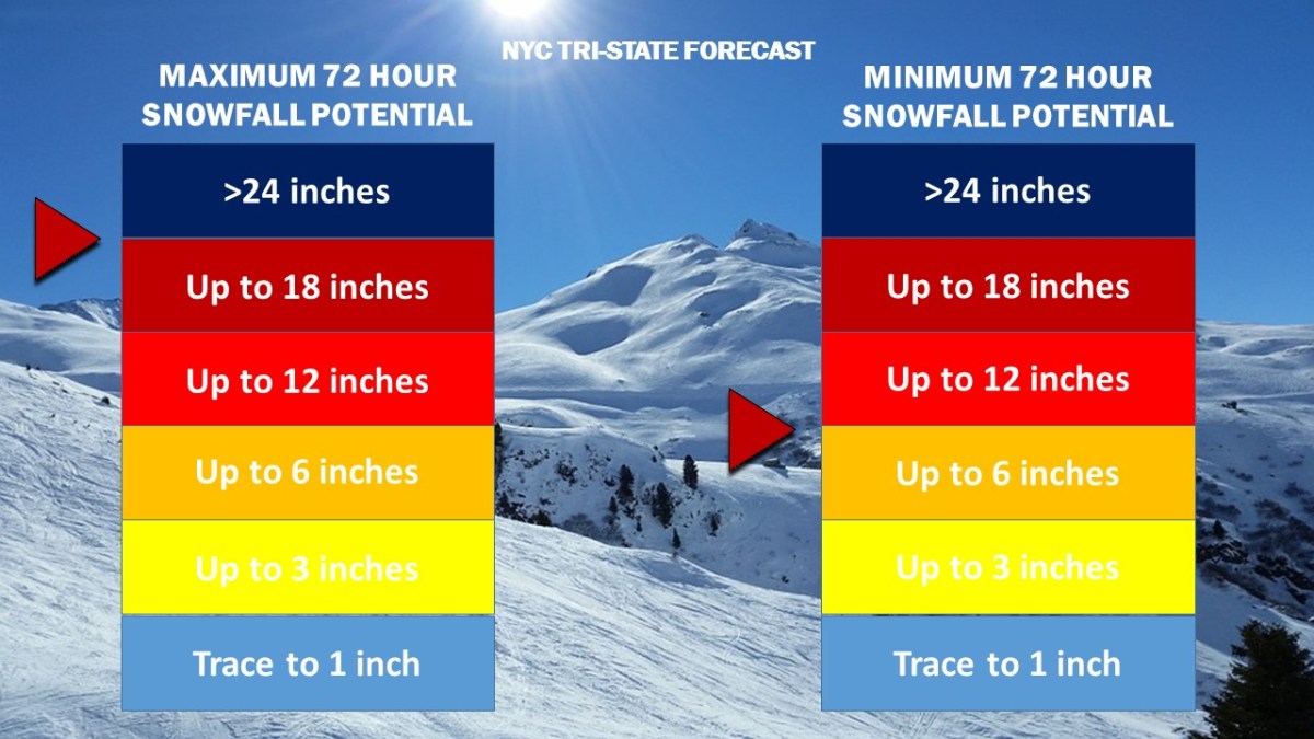
Weather 360 NYC Tri-State 72 Hour Snowfall Forecast as of 9:30 AM today.

While snow totals to the east of the city in Long Island will likely remain at or below the one foot mark, locations to the west, northwest, and north of the city have the potential to reach over 18 inches of snow by Thursday morning.

Due to high winds combined with heavy snow this afternoon, it is advised that all unnecessary travel is avoided until the storm subsides tomorrow.

Strong Line of Thunderstorms Expected Monday Evening

A cold front moving in from the plains is expected to arrive in our area tomorrow evening. The North American Mesoscale Forecast System (NAM computer model), forecasts a line of thunderstorms to develop over central Pennsylvania and New York before making its way over the NYC Tri-State by 8 pm ET.

The current NAM computer model run for 7 pm ET Monday 6/19 (Image by TropicalTidbits)

Weather360 is forecasting frequent lightning, hail, high winds, and potentially a few tornadoes in these storms tomorrow. The Storm Prediction Center (SPC) forecasts an ‘Elevated Risk’ for severe weather tomorrow, meaning that strong storms are likely with the potential for isolated tornadoes.

Severe Weather 3b
Weather360’s Sunday afternoon forecast for Monday Evening, updated information can be found on our ‘Weather Outlook’ page.

Already today the main parameters for severe storm development (CAPE, shear, helicity, and ML LCL) are already favorable for strong thunderstorms. Please have access to a cellphone, television, or radio tomorrow in the event that the National Weather Service issues a severe thunderstorm, flash flood, or tornado warning. Tornadoes can and do occur in this area of the country, please take shelter immediately should a warning be issued for your area.

Crippling Blizzard Expected Tuesday

Winter Storm and Blizzard Watches remain in effect for locations across the NYC area. Weather 360 is now forecasting that up to 2′ of snow is possible in locations situated mainly to the west and the north of the city, and that at least 6″ of snow will accumulate even in the event the storm does not make a “direct” hit.

Snow Accumulation 12
Weather 360 72 Hour Snow Totals Forecasts update about every 6 hours ahead of storms. Currently, Weather 360 is calling for at least 6″, and at most up to 2′.

It is increasingly likely that blizzard conditions will be felt on Tuesday, as heavy wet snow combined with wind gusts approaching 45+ mph may make for white out conditions. Due to the wind and snow, expect power to go out in some areas and take appropriate precautions ahead of the storm. For more information regarding the dangers this storm poses, consult the NWS at weather.gov. We’ll continue to keep you updated on the progress of this storm both here, and on our Facebook page.

Major Winter Storm Tomorrow

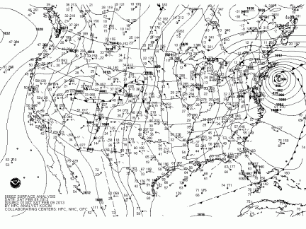
Winter Storm and Blizzard Warnings have been issued for the entire I-95 Corridor from New York to Boston. Exactly 4 years ago, Winter Storm Nemo created the exact same situation. Winter Storm Nemo, pictured below in an NOAA Surface Analysis, dumped 40 inches of snow in parts of Connecticut, and while tomorrow’s winter storm (named ‘Niko’) will likely dump no more than a foot and a half, it certainly is expected to resemble the historic storm that took place 4 years ago.

winter-storm-nemo-surface-analysis
Tomorrow marks the 4th anniversary of Winter Storm Nemo (above), and for the occasion, a nearly identical system is expected.

Expect high winds and heavy snow lasting from late tonight until tomorrow afternoon to greatly reduce visibility and knock down some tree limbs and power lines. Many schools across the area will likely be closed tomorrow, as the storm will also greatly reduce the ability to travel. Due to the remaining uncertainty in the storm’s intensity as it passes the area, Weather 360 is forecasting snow totals to vary from 6 inches in locations on the immediate coast, to as much as 16 inches for locations not much further inland.

 For information regarding watches, warnings, and advisories, visit weather.gov, and in the meantime, we’ll keep you posted.

Foot of Snow Possible Thursday

Over the past several days, more and more computer models have suggested that a ‘clipper’ snow storm would intensify just off the coast, dumping upwards of several inches of snow. Due to temperatures well-above average tomorrow, expect a small layer of ice on surfaces under all the snow Thursday, as some precipitation early on will fall as snow, melt, then freeze before it can accumulate.

nam_namer_054_sim_radar.gif
Above is the 6 UTC run of the NAM computer model displaying simulated radar for 7 am Thursday. Source: NOAA

Weather 360 is forecasting that a maximum of 12-18 inches of snow at this time in central portions of the Metro Area, with at least 3-6 inches of snow in locations further to the north, or at the freezing line at the immediate coast. The forecasted track and intensity of this storm are still fluctuating, so more information will be posted over the coming days. As always, please consult the NWS at weather.gov before making any decisions.


Hermine Tracks East, Remains a Threat to Tri-State

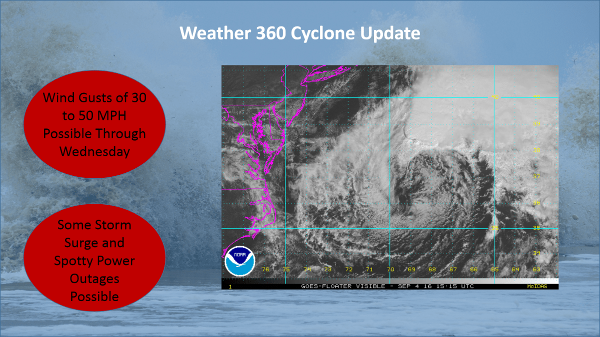
Hermine continued its east-northeastward track overnight, bringing it to the eastern side of the NHC’s ‘cone of uncertainty’.  Although the effects from Hermine along the coast will be less significant for large swaths of The Mid Atlantic and southwestern New England, Hermine still poses a threat to life and property.

Labor Day Weekend is normally a time when people go to the beaches to celebrate the unofficial end of summer, but rip currents, high waves, and high winds from Atlantic City to Boston may put a damper on your plans. Along with this, expect there to be wind gusts high enough to bring down some large branches and trees, especially on Monday, bringing up the potential for some spotty power outages.

For more information on Hermine, visit our Tropical Cyclones page and check for official information at hurricanes.gov and weather.gov.

Severe Thunderstorm Potential in NYC Today

Following a round of moderate to heavy rain this morning in and around New York City is the potential for severe thunderstorms in the mid afternoon.  With the next round of storms expected to impact the area comes the threat of hail, high winds, heavy rain, and lightning (not ruling out the potential for an isolated tornado or two).  In order to stay safe, take appropriate action now if you live in the NYC Metro Area.  Make sure that you have a flashlight, water, and a weather radio available in the event of an emergency.

An important factor in forecasting severe weather is the Convective Available Potential Energy or CAPE value. The CAPE is a measure related to the total energy available for convection and the maximum vertical updraft speed.  It is important to note that the greater the CAPE, the more likely it is for severe thunderstorm development.  It becomes much more common for severe thunderstorms to develop in and around the NYC area when the CAPE value is above 800, give or take a few, and as of now, the SREF ensemble computer models (run by the Storm Prediction Center)are suggesting a CAPE value of around 1,200.  Along with this, more short range computer models such as the HRRR are suggesting a line of thunderstorms popping up around 4:00 PM EST today across the area. Remember to be on the look out for severe weather today and heed any and all advice distributed by the National Weather Service.

Severe Weather to Impact NYC

The National Weather Service has issued multiple Severe Thunderstorm Warnings for the New York City Metro Area.  This comes after a day of pouring rain that has saturated the ground.  These storms will impact the area over the following several hours and may bring wind gusts of upwards of 60 mph along with lightning and some hail.  Weather 360 advises to heed all warnings and to go inside if not already to avoid potential injury.

Severe Thunderstorm Alert

As of 2/24/2016 at 8:00 PM EST

ALERT: THE NATIONAL WEATHER SERVICE IN UPTON, NEW YORK HAS ISSUED A SEVERE THUNDERSTORM WATCH EFFECTIVE UNTIL 2:00 AM EST THURSDAY FOR THE ENTIRE NYC METRO AREA.  A TORNADO WATCH IS CURRENTLY IN EFFECT FOR LOCATIONS JUST TO THE WEST OF THE METRO AREA.

Strong to severe thunderstorms are expected to impact the area later tonight.  Moderate to heavy rain has already begun to fall across some portions of the area.  By 11:45 PM tonight, a line of strong to severe thunderstorms is expected to envelop the area, potentially bringing hail, strong winds, lighting, flooding, and even some tornadoes along with it.

Look out for emergency weather warnings that the NWS may issue over the following several hours.