Catastrophic and Unprecedented Hurricane Michael Makes Landfall in Florida

The eye wall of the now 150 mph Hurricane Michael is making landfall near Panama City, Florida. This storm has rapidly increased in strength over the past 24, 48, and 72 hours to become a now unprecedented event in the history of the Florida Panhandle.

Hurricane Michael Image
Hurricane Michael, a strong Category 4 hurricane, making landfall several miles to the east of Panama City, Florida. (1:30 pm ET October 10, 2018)

The National Hurricane Center has forecasted storm surge to exceed 14 feet in some locations in the Big Bend region of northwestern Florida. The NHC has also extended Hurricane Warnings as far inland as southeastern Georgia, with Tropical Storm Warnings extending as far north as the Outer Banks of North Carolina.

Weather.gov Hurricane Michael.png
Due to the fast-moving nature of Hurricane Michael, the storm will remain at tropical storm or hurricane strength as it traverses the Southeast United States. (Image Source: Weather.gov)

The National Weather Service has also extended Extreme Wind Warnings for locations from Panama City to Apalachicola as the eye wall continues to bring winds in excess of 130-150 mph onshore.

Hurricane Michael has made history, not only as being the first category 4 hurricane to make landfall in the Florida Panhandle, nor only with its being  the lowest pressure (919 millibars) recorded in the area, but also with its having formed and struck in the month of October.

For more information regarding Hurricane Michael and its effects, please consult the National Hurricane Center at http://www.nhc.noaa.gov, or the National Weather Service at http://www.weather.gov.

Stay safe!

Massive Hurricane Florence to Slam the Carolinas

Hurricane Florence, now a major category 3 hurricane with winds in excess of 115 mph, is expected to restrengthen as it makes its way towards the coast. Storm Surge and Hurricane Warnings are in effect from Myrtle Beach, South Carolina, to the northern Outer Banks in North Carolina, with Hurricane Watches extending as far south as Charleston.

Florence NHC Track 09 12 18.png
Official NHC track and wind field assessment as of 8:00 PM ET on September 12, 2018.

Although the effects of Hurricane Florence will begin to impact the Carolinas starting tomorrow afternoon, strong winds and heavy rain will continue to lash the region until the end of the weekend due to the storm’s unusual path.

Florence NAM 3KM Future Radar 09 12 18.png
This is the  18z 9/12/18 run of the NAM 3km computer model depicting an extremely intense Hurricane Florence approaching the Wilmington, NC area.

For the past several days, computer model guidance has shifted to suggesting that Hurricane Florence will begin to slow down and proceed to parallel the coastline come Friday evening. The storm’s unusual path will force extremely dangerous winds and storm surge across a swath of land extending from the Outer Banks to South Carolina, placing millions under the threat of life-threatening conditions. Unfortunately, these conditions will only be compounded and exacerbated by the upwards of 3 feet of rain forecasted to fall in some areas.

The National Hurricane Center is forecasting winds to exceed 120 mph upon Hurricane Florence’s arrival near the coastline, with a storm surge exceeding 9-13 feet in some locations, making this storm extremely dangerous for those in its path.

If you have been ordered or asked to evacuate, please heed these orders immediately before it becomes too late to do so. All preparations for this storm should be completed immediately.

For more information, please consult the National Hurricane Center at http://www.nhc.noaa.gov or your local emergency management office.

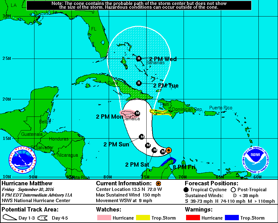
Major Hurricane Matthew Taking Aim at Carribean

Hurricane Matthew, now a major hurricane, has undergone rapid intensification over the past 24 hours. The National Hurricane Center has posted Hurricane Watches for Jamaica, as the storm is expected to make landfall there as a category three storm in a few days. After making landfall in Jamaica and traversing Cuba, Matthew is expected to reemerge over The Bahamas as a strong category 2 or weak category 3 storm.

Pictured above is the HWRF computer model simulated Infrared Satellite image for Wednesday October 5. This image was provided by Tropicaltidbits.com.

As far as forecasting the track and intensity of Matthew after this point, not much can be said besides that the storm will either skim the Southeast’s coast before turning out to sea, or the storm will ride parallel near to the coast all the way up to Canada. Either way, Hurricane Matthew poses a serious threat to life and property in locations ranging from the Caribbean to the Eastern Seaboard. More updates will be available here, and on our Facebook page over the following several days, but for official information, please consult The National Hurricane Center at http://www.nhc.noaa.gov.

Hurricane Matthew.gif
Above is The National Hurricane Center’s projected path for Hurricane Matthew over the next 5 days. Hurricane watches are currently posted for all of Jamaica.


As Atlantic Hurricane Season Winds Down, Western Mexico Faces Major Hurricane Threat

10/22/15 8:00 PM AST: Hurricane Patricia strengthens rapidly to a Category 4 hurricane, Hurricane Warnings in place.

Although the Atlantic Hurricane Season is winding down, a massive Category 4 Hurricane Patricia is quickly moving towards the Central Mexican Pacific coastline.  This monster storm will also help bring massive amounts of rainfall to these areas along with parts of the Southern United States over the next several days.

The Forecast

At this time yesterday, Hurricane Patricia was only a Tropical Depression with sustained winds of only 35 MPH, and the forecast track was only suggesting the landfall at a maximum of a Category Two storm on the Mexican Coastline.  So what happened?

Well, since yesterday at this time, the forecast models have shifted as to support massive quick development of the storm due to warm ocean waters, and minimal wind shear.  Even though the official forecast track yesterday called for a moderate hurricane impact on the Mexican Coastline, some computer models such as the HWRF and the GFDL (Hurricane Computer Models) suggested that at least a potential Category Three storm impact was possible starting late on Tuesday.  These same computer models have steadily suggested a more violent impact since then.

For anyone with interests across along the Central-Pacific Mexican Coastline, please continue to monitor the storm and visit the NHC’s website for more information.

Joaquin Expected to Impact Bermuda, Watches and Warnings Issued

Weather Bulletin – 10/3/2015 2 PM AST

The National Hurricane Center in Miami Florida has issued a Tropical Storm Warning and a Hurricane Watch for the Islands of Bermuda.  The strong Category Four Hurricane Joaquin is now moving quickly to the northeast towards Bermuda.  Joaquin’s center is expected to pass within 75 miles to the west of Bermuda in about two days, as a potentially high Category Two, or low-grade Category Three storm.  Due to Joaquin’s potential proximity to the island nation, the  NHC urges residents to take precautions immediately and to be prepared for the worst.

We’ll keep you posted – Weather 360

Hurricane Joaquin is a Category Four Storm, Track Uncertainty Remains

As of October 1 2015 12:00 PM Atlantic Standard Time (EDT)

Hurricane Hunter Aircraft flying at low altitudes has recovered wind speeds upwards of 115 Knots (About 130 MPH), and the storm now has a Mean Sea-level Pressure (MSLP) of 939 millibars. Joaquin is still moving southwest into The Bahamas, but is expected to reach the Jet Stream shortly and begin its turn to the north.  At this moment, one on a satellite image may view this change in direction, as it has just begun.  As this has just begun, the storm is still moving to the west, so the storm will likely stay on the slightly westward side of the current NHC Track Cone issued at the 11 AM 15 Advisory Update.  At the moment many of the computer models seem to be incorrect in saying it would temporarily stall out in The Bahamas and sling-shotting to the northeast, for the storm has started to move slightly to the northwest.

Locations across the East Coast that need to be on alert are: North Carolina, Virginia, Maryland, Delaware, New Jersey, New York, Connecticut, Rhode Island, and Maine.

More updates soon here on Weather360.

For emergency information, consult the NHC at http://www.nhc.noaa.gov

Remnants of Erika may redevelop, Tropical Storm Fred forms, Hurricane Ignacio may impact Hawaii

End of August Weather Overview: 2 PM EDT/AST, 8 AM HST August 30th 2015

Erika Redevelopment Recap

Over the past several days the weather world has been keeping a close eye on Erika, just about until yesterday, when it became a remnant low off the northern coast of Cuba.  After that point at 9:30 yesterday, almost all hope was lost for the redevelopment of Erika, but according to some short range computer models, the remnants moving northward across Central Florida, may redevelop a center of circulation soon off the Southeastern Coast.  So we’ll keep a close watch on this system over the upcoming several days.

Tropical Storm Fred Overview

Tropical Storm Fred formed yesterday off the coast of the Cape Verde Islands and is expected to become a hurricane while moving further northwest towards the central Atlantic.  Fred will thereafter weaken to a Tropical Storm once more and move quite quickly through the central Atlantic, the eventual destination is still at this point unknown.

Hawaii Hurricane Threat

Hurricane Ignacio is now a Category Four storm with winds upwards of 140 MPH, this storm is barreling to the northwest and is expected to graze the northern sides of the islands of Maui and the Big Island.  At the moment, Tropical Storm Watches are in effect for locations within The Big Island and all of Maui County.  For those with interests in the islands potentially affected by the storm, please continue to monitor the progress of this storm over the upcoming few days.

Weather 360 will continue to keep you updated on all of these threats over the coming days.