Hurricane Matthew Expected to Slam Florida

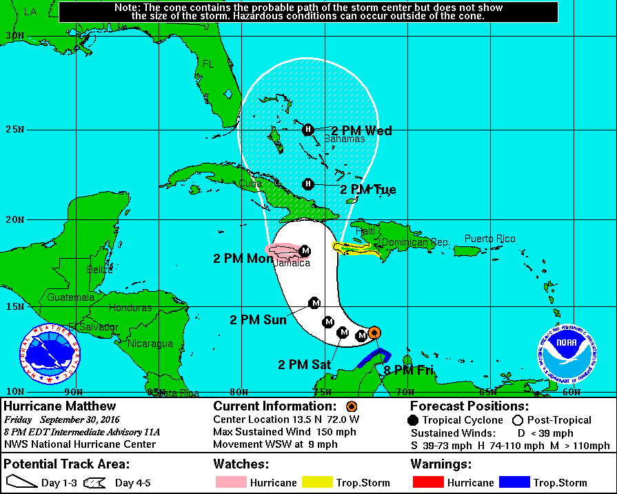
The category 3 Hurricane Matthew has prompted tropical storm watches, tropical storm warnings, hurricane watches, and hurricane warnings for nearly the entire state. Winds in excess of 100 mph may be expected across large swaths of the Southeast from southern Florida to South Carolina in the coming days.

[Image of probabilities of 34-kt winds]
NHC Tropical Storm Force Winds Probabilities for Hurricane Matthew.

Millions have been ordered to evacuate from the coasts of Florida, Georgia, and South Carolina. The time is NOW to prepare for the storm. DO NOT WAIT UNTIL THE STORM STARTS TO PREPARE. Hurricane Matthew is an extremely dangerous and life threatening storm, and potential impacts to The US and The Bahamas may be comparable to that of Hurricane Andrew in 1992.

*Hurricane Matthew is an extremely dangerous storm, it is highly recommended to prepare and evacuate as ordered by your local governments should they do so. Please consult The National Hurricane Center at http://www.nhc.noaa.gov for more info.*

Hurricane Matthew Bears Down on Caribbean, Poses Threat to US

The monster  category 4 Hurricane Matthew is now beginning its path of destruction as it nears the northern Caribbean Islands. Up to over a foot of rain is expected over a wide swath of Haiti, Cuba, and Jamaica, creating the possibility for mudslides and flash flooding.

The National Hurricane Center has forecasted the storm to barrel through The Caribbean and The Bahamas before potentially impacting the US.

Hurricane conditions can be expected across Jamaica, eastern Cuba, and all of Haiti over the next 48 hours, and hurricane conditions are increasingly likely for large swaths of the Bahamas as well as The Turks and Caicos.

After about 72 hours out, the forecast becomes a bit less certain, as it begins to be reliant on, multiple factors, for now, we’ll focus on two.

  • Factor 1: The low pressure system in the Pacific Northwest is weaker than expected, meaning that once it reaches Hurricane Matthew on the East Coast (if at all), it will not be able to slingshot the storm away from the coast as previously thought.
  • Factor 2: The high pressure system in the Atlantic is much more dominant than expected, indicating that it may act as a block in Matthew’s path, forcing it much, much closer to the coast, as reflected in last night’s shift in the spaghetti model plots.

*Hurricane Matthew is an extremely dangerous storm, it is highly recommended to prepare and evacuate as ordered by your local governments should they do so. Please consult The National Hurricane Center at http://www.nhc.noaa.gov for more info.*

Category 5 Hurricane Matthew may Impact US, but Uncertainty Remains

Hurricane Matthew, now a category 5 storm with winds in excess of 160 mph, is well on its way through the Caribbean, but is expected to take a sharp northerly turn sometime over the next 24 hours.

Current Rainbow Top Infrared Satellite view of Hurricane Matthew provided by the NOAA.

Hurricane Matthew is now, (unofficially as of 7:oo am 10/1/16), a category 5 hurricane, with winds in excess of 155 mph. Overnight, some interesting shifts in the computer models, a the NAVGEM as well as the GFS now point to a potentially devastating storm in the Northeast US sometime over the next week, on the other hand, the ECMWF has held firm in its ‘out to sea’ stance. There will be some interesting things to look for come the 12z run (by about 2:00 pm Eastern Time), so we’ll keep you updated.

*Hurricane Matthew is an extremely dangerous storm, it is highly recommended to prepare and evacuate as ordered by your local governments should they do so. Please consult The National Hurricane Center at http://www.nhc.noaa.gov for more info.*

Major Hurricane Matthew Taking Aim at Carribean

Hurricane Matthew, now a major hurricane, has undergone rapid intensification over the past 24 hours. The National Hurricane Center has posted Hurricane Watches for Jamaica, as the storm is expected to make landfall there as a category three storm in a few days. After making landfall in Jamaica and traversing Cuba, Matthew is expected to reemerge over The Bahamas as a strong category 2 or weak category 3 storm.

Pictured above is the HWRF computer model simulated Infrared Satellite image for Wednesday October 5. This image was provided by Tropicaltidbits.com.

As far as forecasting the track and intensity of Matthew after this point, not much can be said besides that the storm will either skim the Southeast’s coast before turning out to sea, or the storm will ride parallel near to the coast all the way up to Canada. Either way, Hurricane Matthew poses a serious threat to life and property in locations ranging from the Caribbean to the Eastern Seaboard. More updates will be available here, and on our Facebook page over the following several days, but for official information, please consult The National Hurricane Center at http://www.nhc.noaa.gov.

Hurricane Matthew.gif
Above is The National Hurricane Center’s projected path for Hurricane Matthew over the next 5 days. Hurricane watches are currently posted for all of Jamaica.