Less Than Two Weeks After Irma, Maria Promises to Slam Caribbean as Monster Category 5

Hurricane Maria has intensified from a category 1 to a monster category 5 hurricane in under 48 hours. The now 160 mph storm is expected to strengthen further as it makes its first landfall in the eastern Caribbean before making a direct hit on the Virgin Islands and Puerto Rico. Maria possesses winds equivalent to that of an EF 3 to EF 4 tornado and is moving at less than 10 mph, meaning the worst of its winds will bear down on the same locations for up to 6 hours at a time (keep in mind that a tornado typically spends around 30 seconds to 2 minutes affecting one single location). The National Hurricane Center forecasts Hurricane Maria to make landfall in southeastern Puerto Rico as a category 5 storm with sustained winds of 160 mph. The already devastated US and British Virgin Islands can expect extreme winds and rain as well as storm surge over the next 48 hours. This will cause catastrophic damage across Puerto Rico and the Dominican Republic as well.

Hurricane Maria.png
The National Hurricane Center’s cone of uncertainty regarding Maria’s potential track, the storm is also expected to expand as it approaches Puerto Rico and the Virgin Islands.

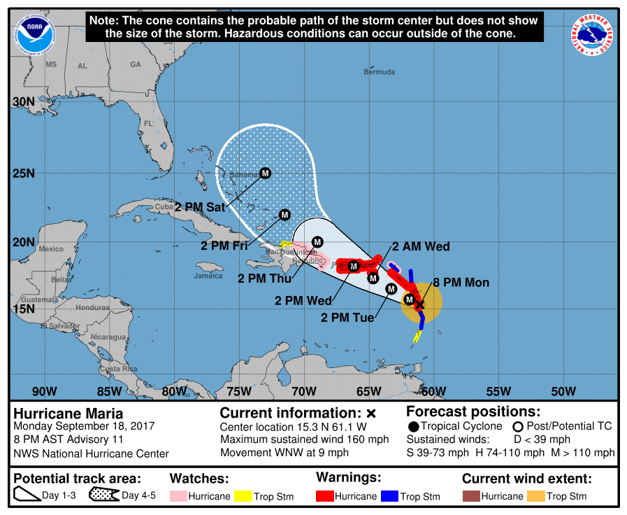
Following its landfall in Puerto Rico, Maria is expected to track into the eastern Bahamas as a category 3 or 4 storm as it continues to move northwestward, potentially impacting the US East Coast over the next week and a half. For further information, please consult the National Hurricane Center at http://www.nhc.noaa.gov and the National Weather Service at http://www.weather.gov.

Category 5 Hurricane Matthew may Impact US, but Uncertainty Remains

Hurricane Matthew, now a category 5 storm with winds in excess of 160 mph, is well on its way through the Caribbean, but is expected to take a sharp northerly turn sometime over the next 24 hours.

Current Rainbow Top Infrared Satellite view of Hurricane Matthew provided by the NOAA.

Hurricane Matthew is now, (unofficially as of 7:oo am 10/1/16), a category 5 hurricane, with winds in excess of 155 mph. Overnight, some interesting shifts in the computer models, a the NAVGEM as well as the GFS now point to a potentially devastating storm in the Northeast US sometime over the next week, on the other hand, the ECMWF has held firm in its ‘out to sea’ stance. There will be some interesting things to look for come the 12z run (by about 2:00 pm Eastern Time), so we’ll keep you updated.

*Hurricane Matthew is an extremely dangerous storm, it is highly recommended to prepare and evacuate as ordered by your local governments should they do so. Please consult The National Hurricane Center at http://www.nhc.noaa.gov for more info.*

HURRICANE PATRICIA IS THE STRONGEST STORM EVER RECORDED IN THE WESTERN HEMISPHERE

8:00 AM AST 10/23/15: HURRICANE PATRICIA NOW HAS SUSTAINED WINDS OF 210 MPH and a pressure hovering just below 880 millibars as it begins to make landfall on the Central-Pacific Mexican Coastline.

This storm is the third strongest hurricane ever recorded worldwide at the moment and is close to second, with this storm making landfall at its peak, mass destruction can be expected, a storm surge of over 20 feet and winds over 200 MPH with gusts over 250 MPH can also be expected.   For anyone who may reside in these areas, if you have not evacuated already, NOW is the time to do so. For those with interests in these areas around Manzillo, Mexico, please continue to monitor the progress of this storm.

We will continue to update on this catastrophic event.

Localized flooding in New England, more reports of mass destruction in Vanuatu

As rain and snow melt continues for much of the Mid-Atlantic and New England, with the threat of some localized flooding, new reports of mass devastation are coming in from Vanuatu.  It is being described as a tragedy, houses completely demolished, trees completely uprooted, reports of several deaths, this is all from the category five monster Cyclone Pam with winds of over 160 MPH.  The destruction that has been caused by this monster cyclone is going down in the record books, possibly as one of the strongest cyclones of all time in the Southern Hemisphere.  The entire nation of Vanuatu has been impacted by this storm.  Thousands are still without power and running water across the islands.

Wherever you are, stay safe.

Rain in the Northeast, mass devastation in Vanuatu

Last night into today for the Northeast US and parts of Southeastern Canada will be either rainy or icy. While there isn’t much to talk about in the Northeast, in the island nation of Vanuatu there is mass devastation after category five typhoon (hurricane) destroys or damages most structures with winds of over 160 MPH and a storm surge possibly over 20 feet (7 meters).  UNICEF released a statement yesterday that it was preparing for the worst.  Reports of widespread devastation and several deaths have been arriving overnight.  To put on top of that there was just another 4.9 earthquake in Vanuatu, although not strong, it could damage already damaged structures.

Cyclone Pam beats down on Vanuatu

The Vanuatu archipelago is being impacted by a monster category five typhoon (hurricane) named Pam.  Pam is dumping nearly two feet of water on the islands of the nation especially on the island which the capital of Vanuatu, Port Vila, is situated.  Typhoon Pam is packing winds over 160 MPH and gusts possibly up to 210 MPH with a storm surge possibly over 20 feet (about 7 meters).  This storm is for the record books, as mass devastation is expected in Vanuatu and some surrounding island nations.

Although most connection in Vanuatu is cut off currently due to the storm, stay safe to those in Vanuatu and for anyone in danger of a natural disaster anywhere.

Could a Cyclone Pam occur in the Atlantic?

A monster category five equivalent cyclone is churning towards Vanuatu with winds of over 160 MPH.  So the question is, could this happen in the US?  The answer is most definitely yes.  This is due to the fact that the same caliber hurricane has occurred before in the Atlantic Basin.  How about Hurricane Katrina, it was a category five hurricane in the Gulf of Mexico before making landfall as a category three in Louisiana just a few days later.  Now, the other question is, could this happen again? The answer is once again yes.  This is due to the fact that a category five hurricane can easily form if there is little wind shear and warm ocean temperatures.  If a hurricane such as the one churning towards Vanuatu now was to impact the US, Weather 360 will immediately talk about what this could mean for the area to be impacted.

CATEGORY FIVE HURRICANE TO IMPACT VANUATU

Although Weather 360 mainly covers the Northeast US, we thought it was important for people t note that a category 5 hurricane (typhoon in that region) will likely impact Vanuatu in the Southern Pacific with the chance of impacting northeastern New Zealand with a high surf and gusty winds as the main storm is likely to stay well offshore.  This storm could be one for the record books in the Southern Hemisphere.  The Atlantic Hurricane Season begins on June 1st. Wherever you are, stay safe!