Florida and The East Coast are Bracing for Hurricane Hermine

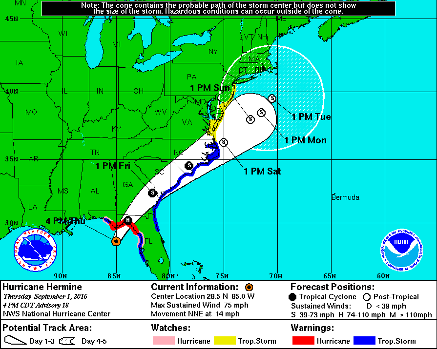
Hurricane Hermine will make history tonight as it will be the first storm of its status to make landfall in Florida in over a decade. Over the past week, what is now Hurricane Hermine went from being an area of exposed low-level circulation to what is now an organized storm capable of producing winds of 75 MPH as well as a storm surge of up to 8 feet on the coast. After impacting Florida tonight, the storm is expected to skirt the Southeast coast with winds exceeding 50 MPH before  moving out over the waters off the Mid Atlantic coast. The following is an image from The NHC displaying the expected track of Hermine as well as current watches and warnings.

nhc hermine hurricane track 9116.gif
This image is provided by The National Hurricane Center in Miami, Florida. Tropical Storm Watches and Warnings on The East Coast stretch from Florida to the NJ/NY border. On The Gulf Coast, Hurricane Warnings are still in effect for The Big Bend region of Florida, and Tropical Storm Warnings remain in effect for areas on The Panhandle as well as areas around Tampa.

This storm poses a serious threat to both life and property and has the potential to affect millions across The East Coast. Please consult the National Weather Service at weather.gov for your local watches, warnings, and advisories.

Tonight crucial in any future development of Tropical Storm Erika

As of 5:30 PM EDT/AST

With the newest NHC track and intensity update of Tropical Storm Erika rolling out, it is time to really stop and think, what is the single most important factor in Erika’s development, what is most crucial in the short term?  The answer is for the most part clear, and cloudy, but it is Hispaniola at the moment…

Hispaniola and the Storm Shredder’s

Sounds like a band, right?  Anyways, the mountains spread across central and southern portions of the two-nation island do inhibit development of tropical cyclones by ripping to shreds their center of circulation in the lower levels.  The mountains of Hispaniola are anywhere between 6,000 and 10,000 feet, tall enough to disrupt the centers and  other clouds at the lower levels.  So really it all comes down to the mountains over the next 12 to 18 hours, and if Erika is strong enough to at the least reemerge after its encounter with the land masses.

Official Alerts:

Tropical Storm Warnings are in effect for the entire length of the coasts of The Dominican Republic and Haiti, along with The Turks and Caicos along with most of The Bahamas.

Tropical Storm Watches are in effect for northeastern parts of Cuba and for locations in the northwestern portions of The Bahamas.

Weather 360 will continue to monitor the progress of Erika over the next several days.