Florida and The East Coast are Bracing for Hurricane Hermine

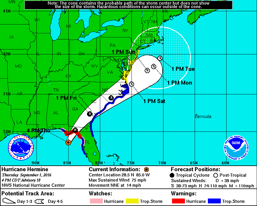
Hurricane Hermine will make history tonight as it will be the first storm of its status to make landfall in Florida in over a decade. Over the past week, what is now Hurricane Hermine went from being an area of exposed low-level circulation to what is now an organized storm capable of producing winds of 75 MPH as well as a storm surge of up to 8 feet on the coast. After impacting Florida tonight, the storm is expected to skirt the Southeast coast with winds exceeding 50 MPH before  moving out over the waters off the Mid Atlantic coast. The following is an image from The NHC displaying the expected track of Hermine as well as current watches and warnings.

nhc hermine hurricane track 9116.gif
This image is provided by The National Hurricane Center in Miami, Florida. Tropical Storm Watches and Warnings on The East Coast stretch from Florida to the NJ/NY border. On The Gulf Coast, Hurricane Warnings are still in effect for The Big Bend region of Florida, and Tropical Storm Warnings remain in effect for areas on The Panhandle as well as areas around Tampa.

This storm poses a serious threat to both life and property and has the potential to affect millions across The East Coast. Please consult the National Weather Service at weather.gov for your local watches, warnings, and advisories.

Invest 99L Expected to Impact US; Intensity Remains Uncertain

Invest 99L formed east of the Leeward Islands as a Tropical Wave about 10 days ago, since then, the storm has made its way to The Straits of Florida, where it is currently attempting to organize itself. Recent satellite images have indicated that the storm is beginning to regain a center of circulation, and recent computer model runs have suggested a potential hurricane impacting portions of western Florida over the following several days.

Although coming closer to the potential time of impact, the storm is not yet organized to the point at which the National Hurricane Center may issue advisories, and a model consensus has by no means yet been reached. Weather 360 will continue to provide updates on Invest 99L on here and on our Hurricane Center page over the coming days.


Invest 99L Poses Threat to US Mainland

Invest 99L is an area of disturbed weather and thunderstorms currently moving west-northwestward at about 20 mph just east of the Leeward Islands. The storm has already defied some expectations that further organization would stall until the area of low pressure moved closer to Hispaniola, and has prompted an Air Force Reserve Hurricane Hunter aircraft trip into the storm later this morning. In the short term, a bit of a model consensus has been reached in terms of whether will the storm go north or south of Hispaniola, and over the past several days, more and more computer models have moved their tracks further to the north of the cyclone-killing mountains in Haiti and The Dominican Republic. The most likely storm track is as follows;  the storm will likely go north of Hispaniola and into the Bahamas before either being pulled north, or continuing on a track west over Florida (Sorry for the uncertainty, it’s still a bit early…) The most likely tracks do have one thing in common beyond the short term track though; most suggest landfall of at least a Tropical Depression somewhere on the East Coast of The United States. Whether the storm traverses Florida and makes another landfall somewhere in the Gulf before being pulled back into The Atlantic, or whether the storm moves up The East Coast, The United States will likely be impacted in some way, shape, or form by what is now Invest 99L.  It is important for those on The East Coast of The United States as well as those on the west coast of Florida to monitor the situation as it progresses and to stay tuned to updates from the National Hurricane Center.

Here's a look at The Tropical Atlantic Basin Satellite Imagery. 
Tropical Depression Fiona is north of The Leeward Islands, 
Invest 99L is east of the Leeward Islands,
And Tropical Storm Gastone is just west of The Cape Verde Islands.

More detail regarding Computer Model variations and outcomes can be found at our Hurricane Center page, where Weather360 is currently covering Invest 99L, Tropical Storm Gastone, as well as Tropical Depression Fiona in The Atlantic.