SOON TO BE TROPICAL DEPRESSION TWO TO IMPACT THE TEXAS COASTLINE

INVEST 90L IS NOW EXPECTED TO MAKE LANDFALL AS A TROPICAL DEPRESSION OR TROPICAL STORM ON THE TEXAS COASTLINE.

In less than 3 days, current Invest 90L is expected to strengthen to a Tropical Depression or Storm and make landfall somewhere between Galveston, Texas, and the Louisiana border.  This storm is expected to not only bring some wind and some storm surge threats, but this storm will bring in enough moisture to cause intense rains and thunderstorms that may cause flooding.

Here’s a look at the GFS’s forecasted amount of  precipitation

GFS forecasted amount of rain for soon to be tropical depression two

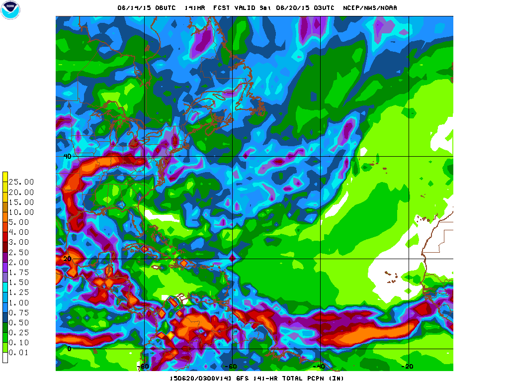
As you can see, over the next 5 or so days, the moisture from the current Invest 90L will make its way through the central United States, before dumping the last of its rain on the majority of the Northeast and portions of Southeastern Canada.  Be on the lookout for heavy rains mid to late week next week in and around NYC.

For more information on Invest 90L, go to our Hurricanes page, and for emergency information for floods or tropical cyclone watches or warnings please refer to the National Hurricane Center (NHC) and weather.gov.

Another disturbance forming in the Atlantic?

The National Hurricane Center (NHC) has created a watch area for a clump of thunderstorms beginning to develop a very weak low pressure.  The computer models have been suggesting that this clump of thunderstorms may develop and grow into some sort of tropical entity and bring some rain and wind to unknown portions of the western Gulf of Mexico Coast.

At the moment, we have not made an official prediction because the NHC is keeping this disturbance’s odds of development at 10%, although once this disturbance’s odds of development do come up, you can look for our official location and intensity forecast on our Hurricanes page.

NHC 5DAY CHART 6 12 15

This is the graphic set out to the public by the National Hurricane Center pertaining to today’s weather conditions across the Tropical Atlantic Basin.

We’ll keep you posted as more information on this disturbance arrives.

TROPICAL STORM ANA MAKES LANDFALL IN SOUTH/NORTH CAROLINA

The 50 MPH Tropical Storm Ana has just made landfall in South/North Carolina, bringing with it, rain, thunderstorms, and some storm surge.  Tropical Storm Ana is the first storm of the Atlantic Hurricane Season, and is also one of the earliest landfalls by a Tropical Cyclone on record. With Hurricane Season starting in over 20 days, some are now wondering how severe this upcoming season will be now… (this information can be found here at Weather 360.)

Where is Ana heading now?

083430W5_NL_sm(NHC prediction cone from earlier this morning.)

Where is Ana heading now?  Well, according to this NHC prediction cone, Ana is making landfall right now in South/North Carolina, (the border of), and will soon lose its Tropical Storm characteristics, but will remain as a Tropical Depression (Ana) with winds of about 30 MPH up until impacting southern New England and Long Island with some waves and some wind (and some rain.)

Weather 360 will keep you posted, stay safe!

Where’s soon-to-be Ana heading?

Have a look at our graphic, the red line on the coast means that imminent landfall is expected in the next two days.

Map of Ana 5 7 15 2019 PM EST UTC -4Map of Ana 5 7 15 2019 PM EST UTC -4

Our graphic shows Invest 90L, which will then likely be Ana, moving into the SC/NC coastline, but due to the current run of the European computer model, we are having this storm ride up the coast a bit further, then veering out to sea before having a chance to make landfall in New York and New England.

At the moment, the National Hurricane Center (NHC), is saying there is a 90% chance of development for this Invest 90L over the next 2 days.  Due to this storm being more associated with the Jet Stream, this storm will likely be first classified as a Sub-Tropical Storm, but don’t be fooled by the “Sub”, these storms are the equivalent of a regular Tropical Storm, and if they break free of whatever holds them back, can quickly strengthen.

For preparedness tips for this storm, consult the NHC or your local emergency management center to stay safe.

Stay safe and be prepared!

WATCH OUT! Tropical Storm Ana to form soon!

Over the next few hours, the very well defined and string tropical disturbance near the coast of the Carolinas may develop into a strong tropical storm.  With sustained winds already hitting 50 MPH and a very closed and well defined center of circulation, the NHC will have to begin issuing watches and warnings for the coastal areas of the Southeast (and even potentially the rest of the East Coast.)  This storm’s intensity will likely stay as a medium to strong Tropical Storm, and will likely track up through the edges of the Carolinas into the Atlantic Ocean near Long Island, before likely veering off to the east with the high pressures.

Have our look at the following graphic from Weather 360, the yellow means potential landfall locations from this storm.  We apologize for the clarity of the following image.

Untitled

IF YOU live on or near the coast of the Carolinas, please take IMMEDIATE ACTION according to the NHC and YOUR LOCAL EMERGENCY MANAGEMENT CENTER.  Please take all appropriate actions suggested by both your local center and the NHC to keep you and your property safe from the storm.

Be smart, and stay safe!

Tropical disturbance in the Atlantic could cause some serious problems to the East Coast

Have a look at the 12 UTC run of the CMC computer model.

potential tropical cyclone

What your seeing is the 12 UTC run from the CMC model, which, if you focus into the Southeastern Coast, you will see a simulated infrared image that depicts a well-developed cyclone with what appears to be an eye to the storm (meaning that this could be near/ at hurricane status soon.)

Due to this storm’s likelihood of being torn apart at the upper levels by a dip in the Jet Stream, it will likely originate as a Sub-Tropical system, with the potential to gain some tropical characteristics before its possible landfall there soon after.  Although the CMC model is predicting a strong system to appear, most of the computer models are keeping this likely at or slightly below Tropical Storm stage.  Still, at the moment, the forecasts are all over the place.

For anyone living on or near the Southeastern Coast, stay tuned to any possible announcements from the National Hurricane Center (NHC) regarding this system.  You can also visit our Hurricanes 360 page for a view at our highlighted areas that may be at risk, be we do stress to always consult with the NHC before doing anything.

Stay safe, and stay tuned.