Major Snowstorm to Remain Offshore

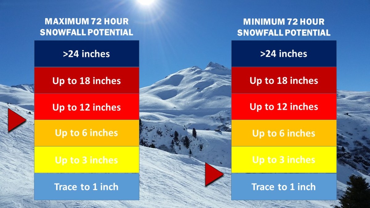
A significant snowstorm expected to bring blizzard conditions and up to a foot of snow to portions of Virginia and the Southeast may bring up to several inches across the Mid Atlantic and the Northeast, prompting winter storm warnings and winter weather advisories for portions of Long Island and eastern Connecticut. The National Weather Service also forecasts light snow accumulation for much of the Metro Area, with areas of Long Island receiving as much as 6 to 8 inches of snow by tomorrow night.

Weather 360 forecasts up to 4 inches of snow for much of southwestern Connecticut, and a half foot or more of snow for much of Long Island. As the snow will start around midday, travel in the afternoon may become slick and at times there may be periods of low visibility.
Snow Accumulation 3.jpg

Please consult The National Weather Service at weather.gov for more info.

Hermine Tracks East, Remains a Threat to Tri-State

Hermine continued its east-northeastward track overnight, bringing it to the eastern side of the NHC’s ‘cone of uncertainty’.  Although the effects from Hermine along the coast will be less significant for large swaths of The Mid Atlantic and southwestern New England, Hermine still poses a threat to life and property.

Labor Day Weekend is normally a time when people go to the beaches to celebrate the unofficial end of summer, but rip currents, high waves, and high winds from Atlantic City to Boston may put a damper on your plans. Along with this, expect there to be wind gusts high enough to bring down some large branches and trees, especially on Monday, bringing up the potential for some spotty power outages.

For more information on Hermine, visit our Tropical Cyclones page and check for official information at hurricanes.gov and weather.gov.

Florida and The East Coast are Bracing for Hurricane Hermine

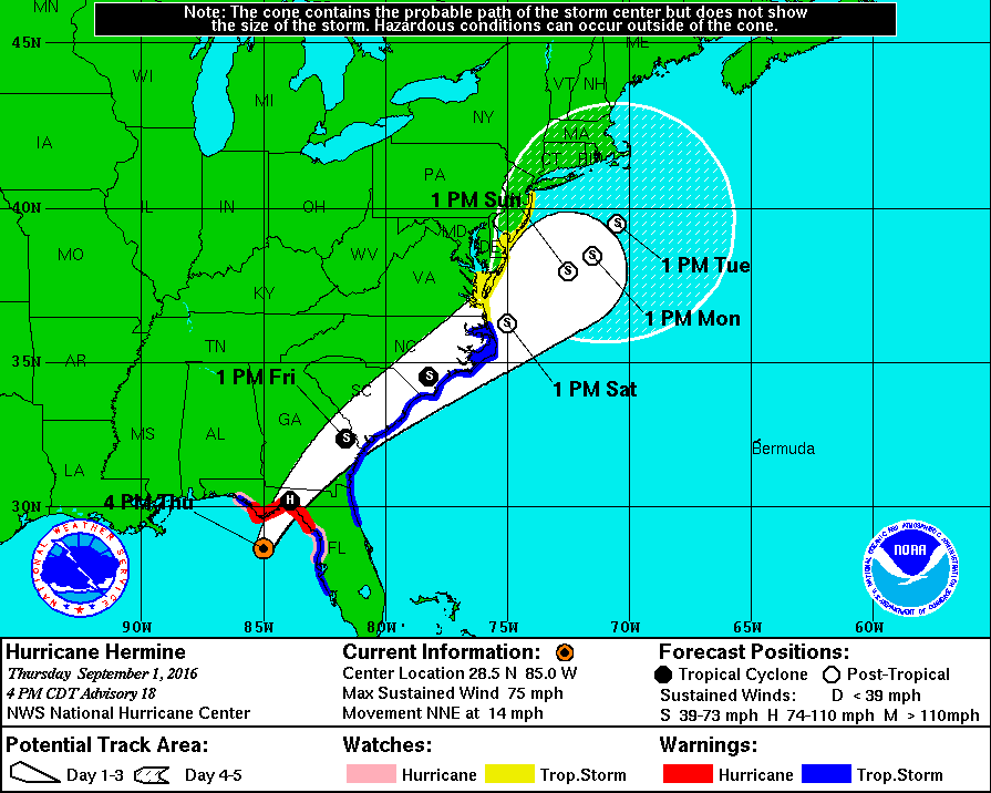
Hurricane Hermine will make history tonight as it will be the first storm of its status to make landfall in Florida in over a decade. Over the past week, what is now Hurricane Hermine went from being an area of exposed low-level circulation to what is now an organized storm capable of producing winds of 75 MPH as well as a storm surge of up to 8 feet on the coast. After impacting Florida tonight, the storm is expected to skirt the Southeast coast with winds exceeding 50 MPH before  moving out over the waters off the Mid Atlantic coast. The following is an image from The NHC displaying the expected track of Hermine as well as current watches and warnings.

nhc hermine hurricane track 9116.gif
This image is provided by The National Hurricane Center in Miami, Florida. Tropical Storm Watches and Warnings on The East Coast stretch from Florida to the NJ/NY border. On The Gulf Coast, Hurricane Warnings are still in effect for The Big Bend region of Florida, and Tropical Storm Warnings remain in effect for areas on The Panhandle as well as areas around Tampa.

This storm poses a serious threat to both life and property and has the potential to affect millions across The East Coast. Please consult the National Weather Service at weather.gov for your local watches, warnings, and advisories.

Tropical Depression Nine Expected to Become a Tropical Storm Today; Track Uncertainty Remains in the Long Term

Tropical Depression 9, the swirling mass of clouds just to the north of The Yucatan in the image to the left, is expected to intensify into a Tropical Storm sometime over the next several hours. The warm waters of The Gulf combined with little shear has finally allowed this storm to grow rapidly over the past couple of days. The National Hurricane Center (NHC) has issued Hurricane Watches as well as Tropical Storm Warnings for much of the Big Bend area of Florida north of Tampa. Although the storm is not currently expected to become a hurricane before landfall,  it will come close to doing so with sustained winds of about 65 MPH, so Hurricane Watches are still in effect for the area. Although a sort of model consensus has been reached regarding the short term for this storm, mayhem continues as some computer models have begun to indicate a shift to the west once it passes North Carolina. If this storm were to shift to the west as now indicated by some of the more trustworthy computer models, it would mean that impacts from this storm would be felt as far north as New England.  As of now, The NHC has put a 50% chance of a 3 to 5 foot storm surge occurring in The Long Island Sound, but until the computer models receive more information, it is unlikely we will know the exact track.  More updates will ne available here over the next several days, but please visit The National Hurricane Center at nhc.noaa.gov before making any decisions.

Wintry Mess to Impact the Area Overnight

Locations across the NYC Metro Area are now under Winter Weather Advisories as snow and other wintry precipitation continues to envelop the area.  Tonight, temperatures will continue to rise, and the wintry precipitation now will slowly transition to sleet and freezing rain, before tapering off as some rain showers across the area very early tomorrow morning.  Currently, areas still receiving snow will likely have accumulated 1-3 inches of snow by now, making it somewhat difficult to get around.  Ground temperatures are still below that of the air, meaning that areas receiving snow or other wintry precipitation will likely continue to see more accumulation.  Tomorrow’s commute will be messy in the early morning  until more rain moves in around 9 AM to wash some of the slush and snow on the roads away.

A Winter Weather Advisory is issued when the National Weather Service decides there will be hazardous weather in a certain area that will include some sort of wintry precipitation.

Most Winter Weather Advisories across the area are set to expire tomorrow around 7 AM.

BLIZZARD SHIFTS NORTH

January 23, 2016 Update:

THE TRACK FOR THIS BLIZZARD HAS SHIFTED NORTH.  LOCATIONS IN SOUTHERN CONNECTICUT ARE NOW UNDER BLIZZARD AND WINTER STORM WARNINGS.

In locations across the New York City Metro Area, the snow has already started to accumulate.  The National Weather Service is now calling for a foot or more in most of the Metro Area.  Expect an additional foot or more of snow with some brief bursts of thunder snow throughout the day starting at 7 am.

The storm has the potential to create extremely dangerous road conditions at times today even in areas not specified under Blizzard Warnings.

There is the potential for widespread power outages across the Tri-State area.

Before making any decisions regarding the weather.  Visit weather.gov.

Winter Storm and Blizzard Warnings Issued

A major winter storm is expected to impact the entire New York City Metro Area tonight into Sunday Morning.

Southern Connecticut Overview:  Currently, Southern Fairfield and Southern New Haven Counties are under Winter Storm Warnings.  Locations in southern portions of Northern Fairfield County can expect near-blizzard conditions, but due to less of a threat further north in the county, the National Weather Service has decided to keep the alert level at an advisory (likewise for Northern New Haven County).  Expect wind gusts around 40 MPH with snow totals 6-15 inches.

Southeastern New York Overview: Blizzard conditions for the Greater New York City area along with Long Island.  Winter Storm Warnings for locations just to the north (Westchester County), and continued Winter Storm Watches for locations just to the north of there.  Expect wind gusts potentially reaching 50 MPH with snow totals ranging from 6 to 18 inches.

Northern New Jersey Overview: Winter Storm Warnings issued for Northwestern portions of this area.  Blizzard Warnings closer to the coast.  Expect snow totals ranging from 6 to 24 inches with wind gusts potentially reaching 60 MPH.

For more detailed information, visit weather.gov

As of 1/22/2016 5:00 PM EST

“Snowmageddon v.2” Update

*UPDATE – 6:00 PM EST 1/21/2016*

The first major winter storm for millions across the Northeast is on its way.  This storm is expected to create blizzard conditions from Connecticut to Virginia and travel delays lasting hours or days from JFK to Reagan Natl.

*The National Weather Service in Upton New York has issued Winter Storm and Blizzard Watches for parts of the New York City Metropolitan Area. Locations in southern portions of Connecticut can expect alerts ranging from Winter Weather Advisories to Blizzard Warnings over the following 24 hours.*

*UPDATE*-  The short range computer models are now in range of this storm and have continued to flip-flop on their positions over the past 18 hours.  The NAM (12 KM) is now calling for the storm to ride further up the Eastern Seaboard and bring over two feet of snow to almost the entire NYC Metro Area.  Other short range computer models such as the WRF-NMM, WRF-ARW, and the RGEM are slowly inching their forecasts further north.  More shifting and settling with more northerly forecasts can be expected over the following day or so as the low pressure that will become this “Snowmageddon V.2” stays closer to the north end of all the previous tracks.

Specific and detailed updates for your area can be found on weather.gov


Tropical Storm Erika may pose threat to entire East Coast if models hold through

BREAKING WEATHER NEWS: 3:45 PM EDT/AST

It is now almost 4 o’clock across the Eastern Seaboard of the US and with the latest run of the computer model runs, some fairly intriguing information has come out as well.

What’s happening?

As of the 12 UTC update, several computer models that do bring Erika up the East Coast, also bring Erika to Category 4 and Category 5 status while nearing the Outer Banks.  This could, if true, mean that a potential catastrophic disaster could be felt anywhere from Florida, to New England, with that in mind, we do remind you that some computer models do still bring a weaker system into Florida, which would avert a potential catastrophe.  For anyone from Florida to New England, we do advise to at least be thinking about preparation for this potential storm.

For those in the Caribbean Islands, including Hispaniola, The Turks and Caicos, and The Bahamas, we recommend immediate action, as we expect a slight shift in the track by the NHC over the next hour.

Bottom Line:  BE PREPARED, Don’t let a storm catch you off guard.

We will continue to keep you updated on the progress of Erika.

Rain and thunder moving in over the weekend could pose a threat to millions

A LEVEL III ALERT MESSAGE BY WEATHER 360 WILL BE RELEASED TOMORROW MORNING AS A PART OF OUR NEW 3.A.S. SYSTEM

The next few days across the Tri-State Area will be for the most part, calm.  With temperatures in the mid to upper 80’s and little to no clouds in the sky, the next few days will feel like true Summer, unlike the temperatures from several days ago that made everyone feel like it was May again.  Although temperatures will be roughly the same during the start of next week, the potential for rain and thunderstorms will start to appear starting around early or midday Sunday.  Therefore, over the next 24 hours, Weather 360 will initiate its first issue of the 3.A.S. (3-Leveled Alert System.)  In this case, an Increasing Level III Alert will be issued as of tomorrow morning.  This means not only to be alert and aware that potentially threatening weather may move into our area over the next 36 hours or so, but also means that the threat level will likely increase to either Level II, or potentially a Level I, Most Urgent Alert.  If this alert was only a normal Level III Alert, then the threat level would likely not increase and one would only have to remain aware of the incoming weather conditions.