Hermine Tracks East, Remains a Threat to Tri-State

Hermine continued its east-northeastward track overnight, bringing it to the eastern side of the NHC’s ‘cone of uncertainty’.  Although the effects from Hermine along the coast will be less significant for large swaths of The Mid Atlantic and southwestern New England, Hermine still poses a threat to life and property.

Labor Day Weekend is normally a time when people go to the beaches to celebrate the unofficial end of summer, but rip currents, high waves, and high winds from Atlantic City to Boston may put a damper on your plans. Along with this, expect there to be wind gusts high enough to bring down some large branches and trees, especially on Monday, bringing up the potential for some spotty power outages.

For more information on Hermine, visit our Tropical Cyclones page and check for official information at hurricanes.gov and weather.gov.

Florida and The East Coast are Bracing for Hurricane Hermine

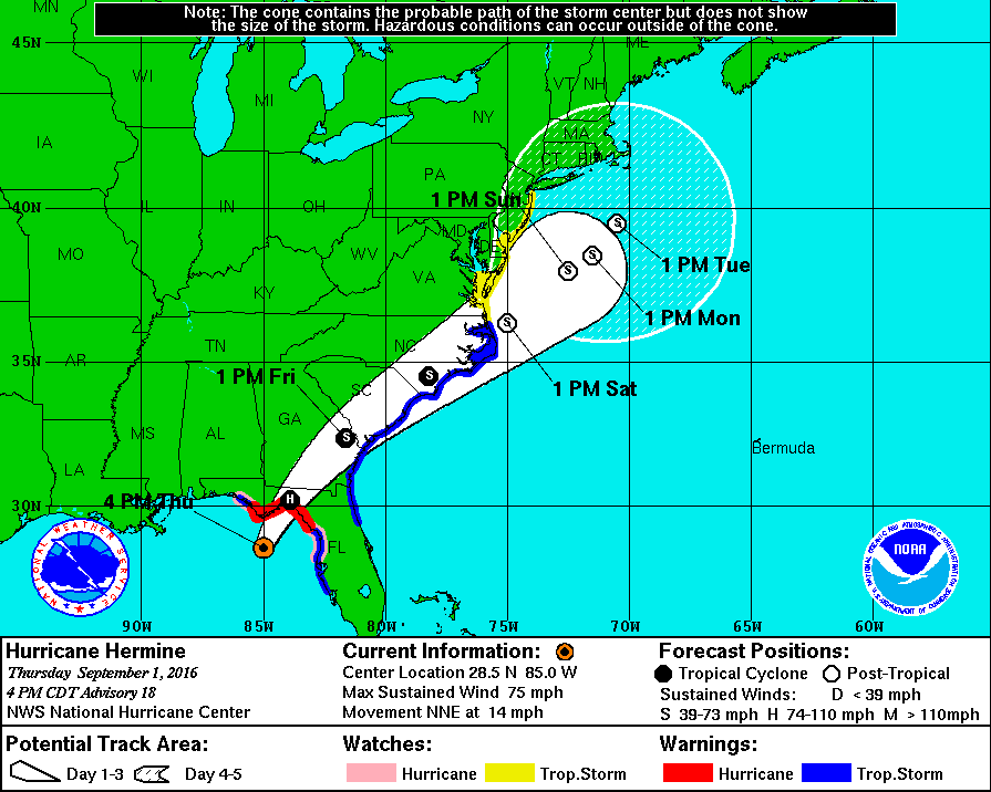
Hurricane Hermine will make history tonight as it will be the first storm of its status to make landfall in Florida in over a decade. Over the past week, what is now Hurricane Hermine went from being an area of exposed low-level circulation to what is now an organized storm capable of producing winds of 75 MPH as well as a storm surge of up to 8 feet on the coast. After impacting Florida tonight, the storm is expected to skirt the Southeast coast with winds exceeding 50 MPH before  moving out over the waters off the Mid Atlantic coast. The following is an image from The NHC displaying the expected track of Hermine as well as current watches and warnings.

nhc hermine hurricane track 9116.gif
This image is provided by The National Hurricane Center in Miami, Florida. Tropical Storm Watches and Warnings on The East Coast stretch from Florida to the NJ/NY border. On The Gulf Coast, Hurricane Warnings are still in effect for The Big Bend region of Florida, and Tropical Storm Warnings remain in effect for areas on The Panhandle as well as areas around Tampa.

This storm poses a serious threat to both life and property and has the potential to affect millions across The East Coast. Please consult the National Weather Service at weather.gov for your local watches, warnings, and advisories.

Tropical Depression Nine Expected to Become a Tropical Storm Today; Track Uncertainty Remains in the Long Term

Tropical Depression 9, the swirling mass of clouds just to the north of The Yucatan in the image to the left, is expected to intensify into a Tropical Storm sometime over the next several hours. The warm waters of The Gulf combined with little shear has finally allowed this storm to grow rapidly over the past couple of days. The National Hurricane Center (NHC) has issued Hurricane Watches as well as Tropical Storm Warnings for much of the Big Bend area of Florida north of Tampa. Although the storm is not currently expected to become a hurricane before landfall,  it will come close to doing so with sustained winds of about 65 MPH, so Hurricane Watches are still in effect for the area. Although a sort of model consensus has been reached regarding the short term for this storm, mayhem continues as some computer models have begun to indicate a shift to the west once it passes North Carolina. If this storm were to shift to the west as now indicated by some of the more trustworthy computer models, it would mean that impacts from this storm would be felt as far north as New England.  As of now, The NHC has put a 50% chance of a 3 to 5 foot storm surge occurring in The Long Island Sound, but until the computer models receive more information, it is unlikely we will know the exact track.  More updates will ne available here over the next several days, but please visit The National Hurricane Center at nhc.noaa.gov before making any decisions.

Severe Weather Outbreak and Tornado Warnings

ALERT: The National Weather Service in Albany, New York has issued a TORNADO WARNING in effect until 4:30 PM Eastern Standard Time.  The National Weather Service is also maintaining a TORNADO WATCH for the entire NYC Metro Area until 10:00 PM EST July 1, 2016.  Heed all warnings set out by the National Weather Service and take all necessary common sense precautions.

This evening into tonight, several rounds of potentially severe thunderstorms are expected to move through the NYC Metro Area, bringing with them damaging winds, hail, lightning, and torrential rains.  The first round of storms has already produced several severe thunderstorms and one storm capable of producing a tornado. Please be advised that in order to receive up-to-date weather alerts and warnings, one will have to consult the National Weather Service via Weather Radio or online.  Weather360 estimates there is a 66% chance for Severe Weather Development to continue throughout the NYC Metro Area going into tonight.

These storms are expected to continue for up to several hours, creating the possibility for widespread power outages and downed trees and tree limbs.

For more information, please consult the National Weather Service while we here at Weather360 will continue to inform you of upcoming threats via our YouTube Channel or right here at Weather360.net.


Severe Thunderstorm Potential in NYC Today

Following a round of moderate to heavy rain this morning in and around New York City is the potential for severe thunderstorms in the mid afternoon.  With the next round of storms expected to impact the area comes the threat of hail, high winds, heavy rain, and lightning (not ruling out the potential for an isolated tornado or two).  In order to stay safe, take appropriate action now if you live in the NYC Metro Area.  Make sure that you have a flashlight, water, and a weather radio available in the event of an emergency.

An important factor in forecasting severe weather is the Convective Available Potential Energy or CAPE value. The CAPE is a measure related to the total energy available for convection and the maximum vertical updraft speed.  It is important to note that the greater the CAPE, the more likely it is for severe thunderstorm development.  It becomes much more common for severe thunderstorms to develop in and around the NYC area when the CAPE value is above 800, give or take a few, and as of now, the SREF ensemble computer models (run by the Storm Prediction Center)are suggesting a CAPE value of around 1,200.  Along with this, more short range computer models such as the HRRR are suggesting a line of thunderstorms popping up around 4:00 PM EST today across the area. Remember to be on the look out for severe weather today and heed any and all advice distributed by the National Weather Service.

Welcome Back to the New Weather360

After a two month developing phase, Weather360 is back up and running even better than ever.  Over the following weeks, a new Severe Weather Forecasting System will be implemented to give specialized information regarding the New York City Metro Area.  Along with this, we plan to provide more insight into oncoming storm systems that may impact the Metro Area as well as large storm systems that may deliver severe outbreaks across the country.

NYC Weather: Snow in April?

This is the Third Edition of the NYC Area Week Outlook by Weather360

Monday:  A wintry mix in the morning will transition to all rain by the afternoon.  Total snow accumulations of up to a couple of inches are possible in some (mainly northern and eastern)  portions of the area.  Highs will hover around in the low to mid 40’s.

Tuesday: Highs dropping into the low to mid 30’s will be associated with clearing skies, making it seem much more like January than April.

Wednesday: High temperatures will peak in the mid 40’s as skies become increasingly cloudy, due to an incoming low pressure system.

Thursday:  Rain associated with a low pressure system moving in from the west will bring in much more seasonable temperatures, with a high in the upper 50’s.   This rain could spell the end to winter for many Ski Resorts throughout the Northeast.

Friday: Cooler temperatures along with clearing skies will make for a somewhat more seasonable day.

The Weekend:  Highs in the 40’s along with mainly clear skies will make for a brisk, cool, early spring weekend.

In the event of an emergency weather situation, please consult the NWS at weather.gov and/or your local Emergency Management Office.

NYC Weather: Winter’s Last Gasp?

This is the Second Edition of the NYC Area Week Outlook by Weather360

Monday:  Snow lingering in the morning will lead to sunnier and drier conditions in the afternoon with highs in the 40’s.  Total snow accumulations of up to several inches are possible in some (mainly eastern)  portions of the area.

Tuesday: Highs nearing 50 will be accompanied by much clearer conditions, making it seem much more like Late-March than Monday did.

Wednesday: Temperatures will finally break 60 degrees n most spots, so say ‘sayonara’ to any remaining snow mounds.

Thursday:  Highs again in the 60’s will make it feel even more like spring, but the threat for showers does increase as the week progresses.

Friday: Highs again in the 60’s will also bring along some light to moderate rain showers.  Only problem though is that its not April yet, so I guess these showers wont bring any May flowers…

The Weekend:  Temperatures in the 50’s along with somewhat clear conditions are likely to remain the most significant weather factor over the weekend.  Although, there is the potential for a Nor’easter to impact the area around Sunday, so it may not be to bad to have some rain gear nearby.

In the event of an emergency weather situation, please consult the NWS at weather.gov and/or your local Emergency Management Office.

NYC Weather: Rain, Milder Temperatures, and Snow This Week?

This is the First Edition of the NYC Area Week Outlook by Weather360

Monday: Rain moving across the area will be accompanied by cooler temperatures hovering in and around the 40’s.

Tuesday: Rain will taper off towards the late morning leading to cloudy conditions with highs maybe reaching the 50’s.

Wednesday:  Some showers with temperatures around the 60 degree mark will create a more spring-like feel again.

Thursday:  Some light rain showers will bring slightly cooler temperatures in the mid 50’s.

Friday: Clear skies are expected along with temperatures still in the mid 50’s.

Weekend:  Saturday will be much like Friday, but the potential for a significant Nor’easter exists starting Sunday, lasting into early next week.  This year, Punxsutawney Phil may actually end up being wrong, as cooler temperatures may create some wintry precipitation across the area, but nothing is set in stone quite yet.


In the event of an emergency weather situation, please consult the NWS at weather.gov and/or your local Emergency Management Office.

Severe Thunderstorm Alert

As of 2/24/2016 at 8:00 PM EST

ALERT: THE NATIONAL WEATHER SERVICE IN UPTON, NEW YORK HAS ISSUED A SEVERE THUNDERSTORM WATCH EFFECTIVE UNTIL 2:00 AM EST THURSDAY FOR THE ENTIRE NYC METRO AREA.  A TORNADO WATCH IS CURRENTLY IN EFFECT FOR LOCATIONS JUST TO THE WEST OF THE METRO AREA.

Strong to severe thunderstorms are expected to impact the area later tonight.  Moderate to heavy rain has already begun to fall across some portions of the area.  By 11:45 PM tonight, a line of strong to severe thunderstorms is expected to envelop the area, potentially bringing hail, strong winds, lighting, flooding, and even some tornadoes along with it.

Look out for emergency weather warnings that the NWS may issue over the following several hours.