Largest Winter Storm of Season Takes Aim at NYC Tri-State

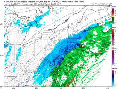
The National Weather Service has issued Winter Storm Warnings for locations across New York, New Jersey, and Connecticut. Snow showers earlier this morning left 1-3 inches of snow on grassy surfaces across the area, but the brunt of the storm is only now beginning to move over Long Island and New Jersey. Heavy bands of snow developing this morning will intensify throughout the afternoon, bringing with them snowfall rates upwards of 2 inches per hour and wind gusts of 30-40 mph.

Snow Accumulation 18-3
Weather 360 NYC Tri-State 72 Hour Snowfall Forecast as of 9:30 AM today.

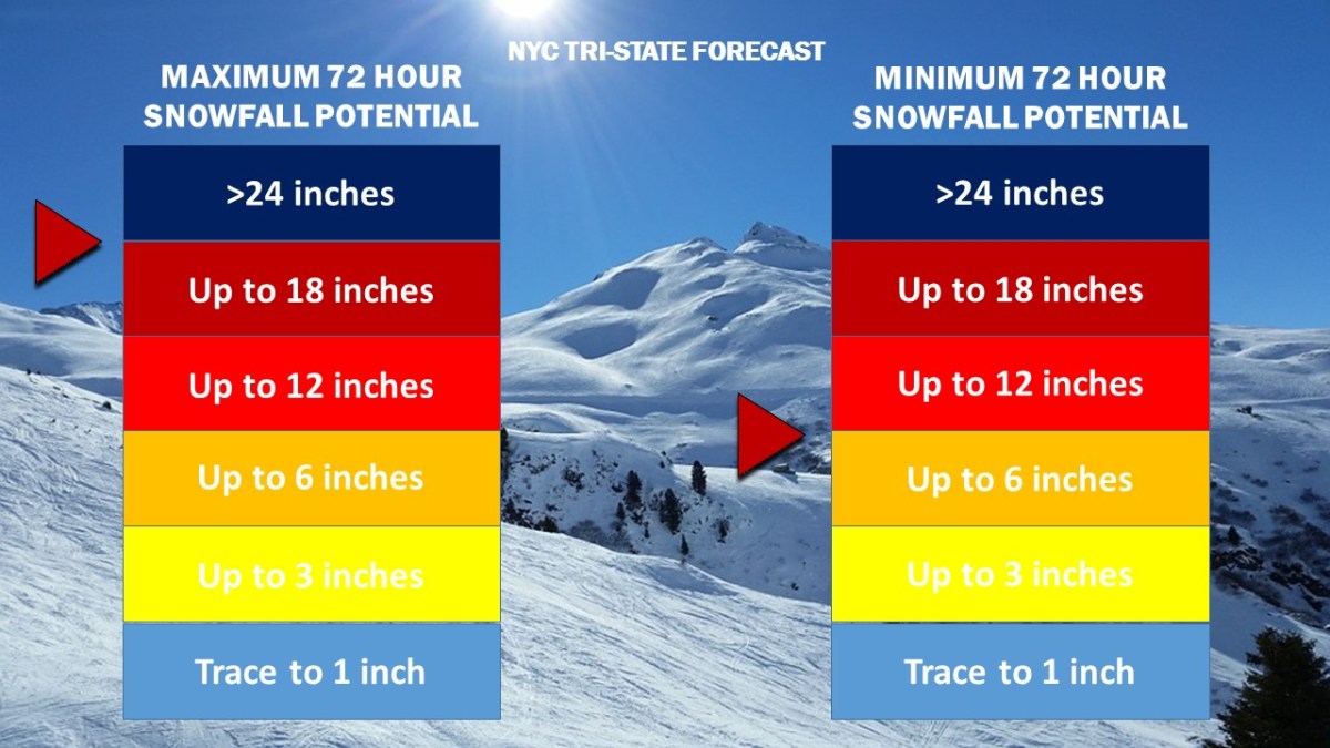
While snow totals to the east of the city in Long Island will likely remain at or below the one foot mark, locations to the west, northwest, and north of the city have the potential to reach over 18 inches of snow by Thursday morning.

Due to high winds combined with heavy snow this afternoon, it is advised that all unnecessary travel is avoided until the storm subsides tomorrow.

Strong Nor’easter to Develop Friday

A strong Nor’easter is expected to develop from a center of low pressure that will move from the Midwest over the Mid Atlantic coast Thursday night. Strong winds and heavy precipitation will likely create power outages and hazardous travel on Friday.

NAM Radar Friday March 2 2018 Noon
NAM 3km computer model display of potential weather conditions at noon on Friday. (image from tropicaltidbits.com)

While it is certain that a Nor’easter will strengthen rapidly over the Mid Atlantic coast, the type of precipitation received in the NYC Metropolitan Area will depend on its proximity to the coast. As of this afternoon, the ECMWF (European) and the NAM (North American) computer models are forecasting enough cold air to transition the heavy precipitation into snow by 10 am or noon Friday. Snow totals in locations where the precipitation does change over to snow could see snow totals exceeding half a foot to over a foot of snow by Saturday morning.

Snow Accumulation 18-2
Weather 360 72 Hour Snow Total Forecast Graphic as of 4:00 PM ET 2/28/2018.


Blizzard Disrupts Travel As Paralyzing Cold Moves In

A significant winter storm has brought up to 12 inches or more of snow along with wind gusts exceeding 60 mph to the Northeast. Schools remain closed throughout southern New York, New Jersey, and Connecticut as wind speeds of 40 mph create wind chills approaching 25 below zero. The National Weather Service has issued wind chill advisories for the area warning of the potential for frostbite to occur within 30 minutes of exposure to the record-breaking low temperatures.

1 5 18 Temperatures NAM
Low temperatures are expected to approach 0 degrees throughout the area with wind chills reaching minus 20 by the morning.

Expect high winds to continue to create low visibility going into Friday afternoon with the potential for downed trees and tree limbs lasting until Sunday morning.

Potential for Significant Nor’easter Soon

A low pressure system is forecasted to develop off the coast of Florida this Tuesday, at which point it has the possibility to come close enough to the coast to impact the Northeast by Thursday.

ECMWF Forecast 12 31 17
European Computer Model (ECMWF) run for Thursday, January 4, 2018, depicting a strong low pressure developing several hundred miles off the US East Coast. (Image courtesy of Weather.us)

As low temperatures correlate to higher yields of snow from the same amount of liquid precipitation, should the storm system track any closer to the coast, upwards of half a foot to a foot of snow or more could be possible. At this time it is still unknown as to whether or not the storm will come close enough to impact the NYC area, but the potential exists for a significant winter storm or blizzard come later this week.

First Winter Storm of Season Expected Saturday

Winter Weather Advisories and Winter Storm Warnings are currently in effect for locations along the I-95 Corridor. While snow accumulations through Sunday morning will likely range from 3” to 6” across much of the NYC Metro Area, the possibility for greater snow totals does exist should the storm system shift to the west, as does the possibility for lower totals in the event that the storm shifts to the east.

NAM3km Rain Snow Forecast December 9 2017
The NAM 3km computer model run from Friday afternoon depicting heavier bands of snow developing across New England by 3 pm. Image from Tropicaltidbits

As the center of low pressure continues to develop, snow has begun to fall across portions of southern New Jersey and is expected to impact our area starting sometime in the mid-morning Saturday. While snow totals will likely remain below the 10” mark, expect moderate snow from around noon to 8 pm Saturday with the potential for some bands of heavier snow around the mid-afternoon. Most roadways will begin to see light accumulations of snow within one to two hours of the first flakes, meaning that all roadways will become slippery by the afternoon and evening.

Snow Accumulation 17-1.jpg
Weather 360 snow accumulation graphic for Saturday December 9, 2017. 3″-7″ can be expected across the NYC Metro Area.

Hybrid Storm Takes Aim on Northeast

Tropical Storm Philippe has merged with a cold front off the coast of Delaware. The new center of low pressure is rapidly intensifying and continuing to push tropical moisture northwards. The core of the storm, as forecasted by nearly all computer models over the past 24 hours, is developing rapidly and, once onshore, is expected to bring with it wind gusts that could reach hurricane force. Today also happens to be the five year anniversary of the landfall of Hurricane Sandy, and the six year anniversary of the Halloween Snowstorm of 2011. This storm, although not as strong as either of these two infamous events, shares multiple, peculiar characteristics with both storms, including but not limited to the ‘negative dip’ in the jet stream, an atmospheric condition responsible for Sandy’s ‘sharp left turn’ into the Mid-Atlantic, as well as its combining with another storm system to create a hybrid-superstorm.

Hybrid Storm 10 29 17 625 PM Radar Image.gif
Northeast US Radar as of 6:25 PM Eastern Time.

The National Weather Service has issued a high wind warning for the entire NYC Metro Area, meaning that high winds will likely cause widespread power outages and will cause fallen items to block roadways. A flood warning is also in effect for the area, meaning that conditions are favorable for roadways and other low-lying locations to flood due to the excessive amount of rainfall. If travel is necessary, exercise extreme caution going into tonight and into tomorrow.

For more information, visit The National Weather Service at www.weather.gov.


Less Than Two Weeks After Irma, Maria Promises to Slam Caribbean as Monster Category 5

Hurricane Maria has intensified from a category 1 to a monster category 5 hurricane in under 48 hours. The now 160 mph storm is expected to strengthen further as it makes its first landfall in the eastern Caribbean before making a direct hit on the Virgin Islands and Puerto Rico. Maria possesses winds equivalent to that of an EF 3 to EF 4 tornado and is moving at less than 10 mph, meaning the worst of its winds will bear down on the same locations for up to 6 hours at a time (keep in mind that a tornado typically spends around 30 seconds to 2 minutes affecting one single location). The National Hurricane Center forecasts Hurricane Maria to make landfall in southeastern Puerto Rico as a category 5 storm with sustained winds of 160 mph. The already devastated US and British Virgin Islands can expect extreme winds and rain as well as storm surge over the next 48 hours. This will cause catastrophic damage across Puerto Rico and the Dominican Republic as well.

Hurricane Maria.png
The National Hurricane Center’s cone of uncertainty regarding Maria’s potential track, the storm is also expected to expand as it approaches Puerto Rico and the Virgin Islands.

Following its landfall in Puerto Rico, Maria is expected to track into the eastern Bahamas as a category 3 or 4 storm as it continues to move northwestward, potentially impacting the US East Coast over the next week and a half. For further information, please consult the National Hurricane Center at http://www.nhc.noaa.gov and the National Weather Service at http://www.weather.gov.

Harvey to Make Landfall in Texas as Major Hurricane

Tropical Storm Harvey is now expected to be the first major hurricane to make landfall in The United States in over 12 years. Up to 24+ inches of rain is possible across the Texas Gulf Coast due to the slow-moving nature of the storm. Sustained winds of 115 mph with gusts potentially approaching 140 mph are now expected across wide swaths of the Texas Gulf Coast.

cone graphic
The NHC 10 am CDT update depicting the potential path and intensity of Harvey over the next several days.


The 12 UTC NAM 3km computer model currently depicts a massive, dangerous storm making landfall in Texas tomorrow afternoon.

For more information, consult The National Hurricane Center at http://www.nhc.noaa.gov as well as The National Weather Service at http://www.weather.gov.

Strong Line of Thunderstorms Expected Monday Evening

A cold front moving in from the plains is expected to arrive in our area tomorrow evening. The North American Mesoscale Forecast System (NAM computer model), forecasts a line of thunderstorms to develop over central Pennsylvania and New York before making its way over the NYC Tri-State by 8 pm ET.

The current NAM computer model run for 7 pm ET Monday 6/19 (Image by TropicalTidbits)

Weather360 is forecasting frequent lightning, hail, high winds, and potentially a few tornadoes in these storms tomorrow. The Storm Prediction Center (SPC) forecasts an ‘Elevated Risk’ for severe weather tomorrow, meaning that strong storms are likely with the potential for isolated tornadoes.

Severe Weather 3b
Weather360’s Sunday afternoon forecast for Monday Evening, updated information can be found on our ‘Weather Outlook’ page.

Already today the main parameters for severe storm development (CAPE, shear, helicity, and ML LCL) are already favorable for strong thunderstorms. Please have access to a cellphone, television, or radio tomorrow in the event that the National Weather Service issues a severe thunderstorm, flash flood, or tornado warning. Tornadoes can and do occur in this area of the country, please take shelter immediately should a warning be issued for your area.

Blizzard Warnings Issued, Massive Snow Accumulation Expected

The National Weather Service has extended Blizzard Warnings for more than half of the NYC Metropolitan Area. Expect high winds in excess of 40 to 60 mph, snow totals approaching 28″, and downed trees and power lines.

Snow Accumulation 14
Expect at least 12″ in most areas, and as much as 2′ in many areas by Wednesday.

This storm will likely be the largest blizzard in 2, or even 5 years. The proximity of this storm to the coast will mean high winds and heavy snow will make for whiteout conditions. If you do not have to, avoid travel. For more information, visit us here or on our Facebook page. To learn more about the dangers this storm poses, consult the NWS at weather.gov.