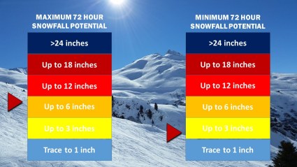
Winter Weather Advisories and Winter Storm Warnings are currently in effect for locations along the I-95 Corridor. While snow accumulations through Sunday morning will likely range from 3” to 6” across much of the NYC Metro Area, the possibility for greater snow totals does exist should the storm system shift to the west, as does the possibility for lower totals in the event that the storm shifts to the east.
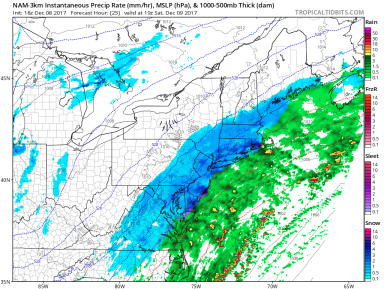
As the center of low pressure continues to develop, snow has begun to fall across portions of southern New Jersey and is expected to impact our area starting sometime in the mid-morning Saturday. While snow totals will likely remain below the 10” mark, expect moderate snow from around noon to 8 pm Saturday with the potential for some bands of heavier snow around the mid-afternoon. Most roadways will begin to see light accumulations of snow within one to two hours of the first flakes, meaning that all roadways will become slippery by the afternoon and evening.