Major Winter Storm Prompts Alerts in NYC Area

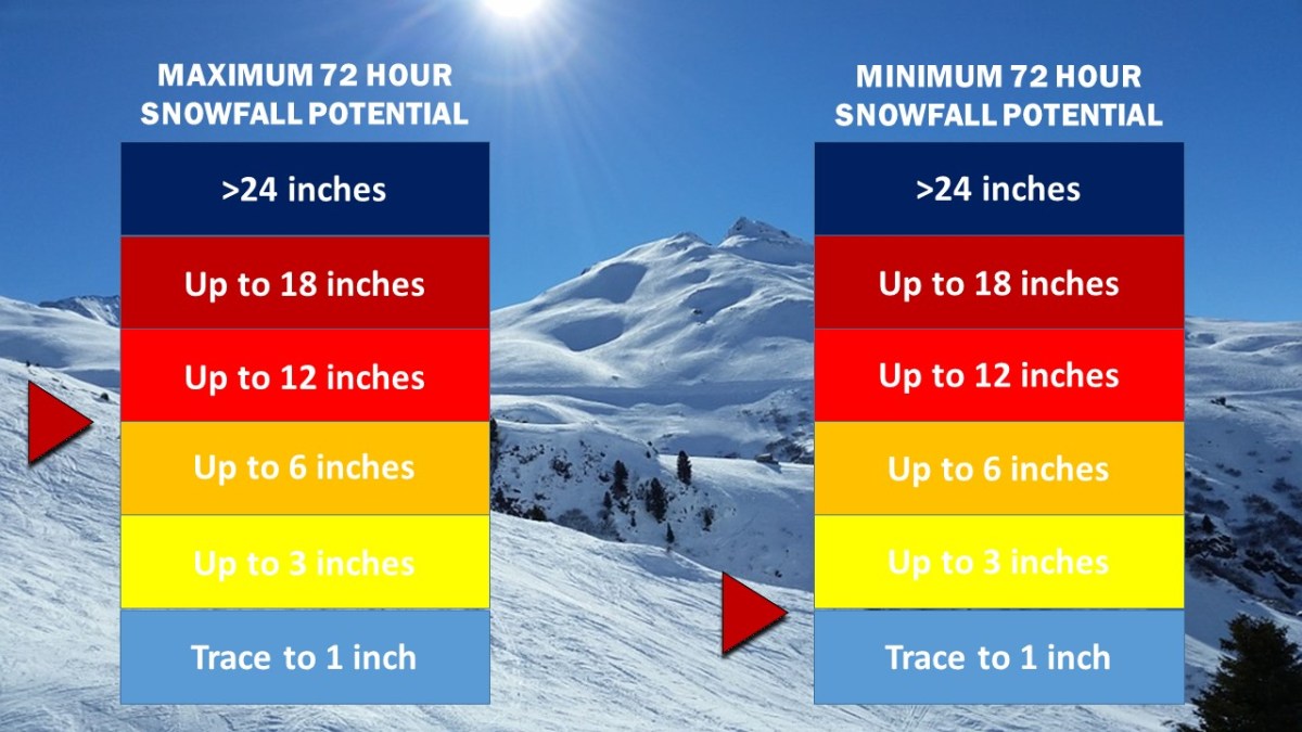
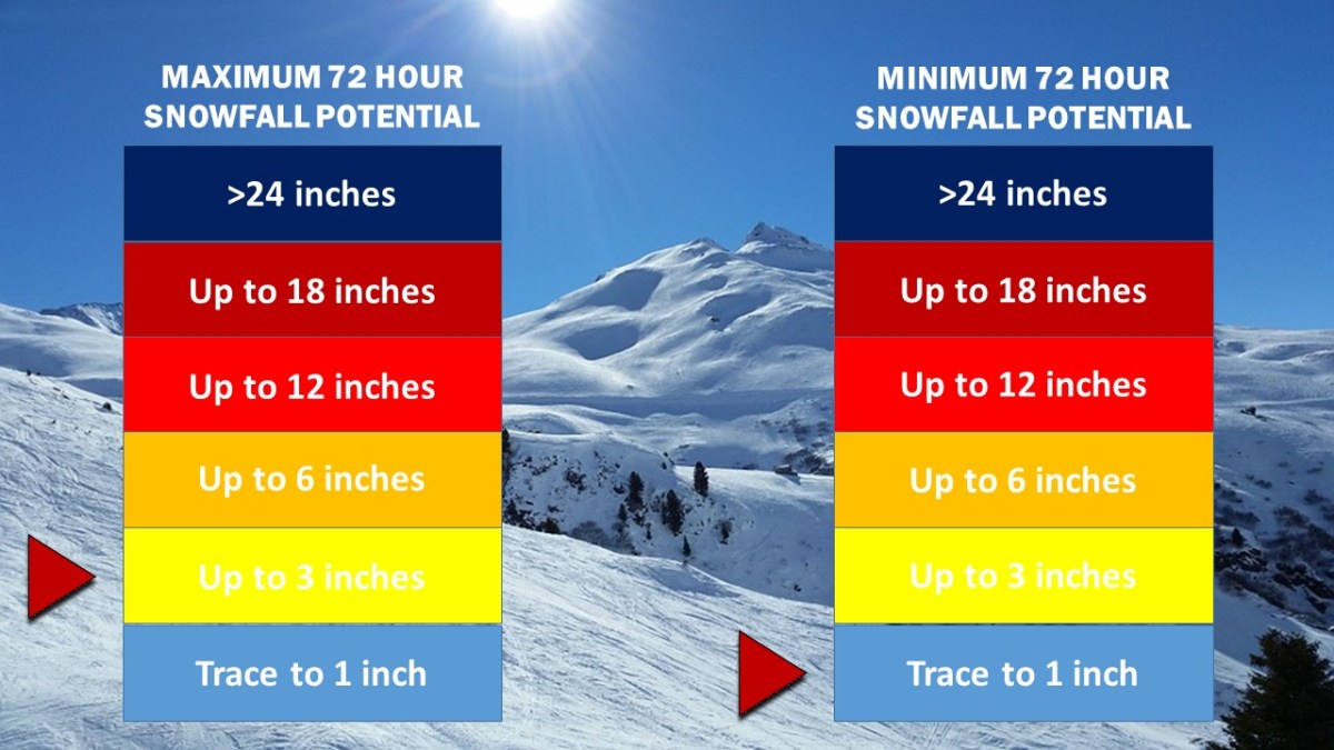
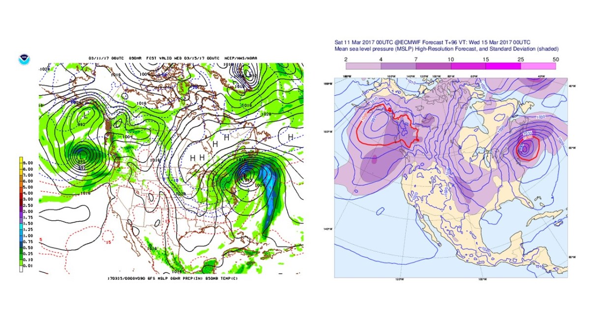
Winter Storm and Blizzard Watches are in effect for the entire NYC area. The National Weather Service is currently calling for up to 18″ of snow in some locations, as more major computer models have continued to suggest a strong Nor’easter developing off the East Coast by Tuesday morning.

GFS ECMWF 3 11 17 3 15 17 BLIZZARD
The GFS and the ECMWF (Euro) computer models from this morning. In the most recent runs, both models have suggested an essentially identical storm that will come in close proximity to the Mid Atlantic/New England coast, putting it in an ideal position to dump massive amounts of precipitation on the area.

Weather 360 is estimating that maximum snow totals in the area may exceed 18″ should the storm remain close enough to the coast to bring its moisture inland, but far enough away to keep temperatures below the freezing line. Even in the event that the storm does not remain in the Nor’easter ‘Goldilocks Zone’, expect there to be at least 3-6″ of snow on the ground by Wednesday morning. For more information regarding the dangers this storm poses, consult the NWS at weather.gov. We will continue to post updates on the progress of this storm over the coming days both here, and on our Facebook page.

Wintry Mess Expected Tomorrow

Only 2 days after the largest storm of the season, the Northeast is on the brink of yet another major winter weather event. In southern portions of the Mid-Atlantic and New England, snow in the morning will likely transition to a wintry mix or rain by the afternoon, but further to the north, cooler conditions will allow for up to 2 feet of snow to accumulate in some areas.

The most significant differences in snow accumulation are expected to occur between locations further to the south and closer to the coast, and those slightly further to the north and inland. In the NYC Metro Area, up to a foot of snow, sleet, as well as some ice is possible in locations to the north of Westchester, whereas in coastal NJ, NY, and CT, only a few inches of snow is expected before the transition to more liquidy precipitation takes place.

Regardless of accumulation, expect weather conditions tomorrow to reduce visibility and hamper travel all day. Please be aware of the weather conditions at your current location as well as in your destination if you intend to travel. More safety related information can be found at http://www.weather.gov.

Major Snowstorm to Remain Offshore

A significant snowstorm expected to bring blizzard conditions and up to a foot of snow to portions of Virginia and the Southeast may bring up to several inches across the Mid Atlantic and the Northeast, prompting winter storm warnings and winter weather advisories for portions of Long Island and eastern Connecticut. The National Weather Service also forecasts light snow accumulation for much of the Metro Area, with areas of Long Island receiving as much as 6 to 8 inches of snow by tomorrow night.

Weather 360 forecasts up to 4 inches of snow for much of southwestern Connecticut, and a half foot or more of snow for much of Long Island. As the snow will start around midday, travel in the afternoon may become slick and at times there may be periods of low visibility.

Snow Accumulation 3.jpg

Please consult The National Weather Service at weather.gov for more info.

Snow Expected Tonight, May Cause Messy Morning Commute

A low pressure system currently located over the Southeast is on its way northeastward, and is expected to impact large swaths of the East Coast tonight into early tomorrow morning, prompting winter weather advisories for locations across southern Connecticut and New York, as well as in parts of New Jersey. Expect the snow to create slick conditions for the morning commute, as it will quickly stick to the ground and pavement.

Weather 360 is forecasting a maximum snow accumulation of about 3 inches in locations close to the coast, with a trace to an inch of snow further inland.

snow-accumulation-2

First Snow Across New York, Connecticut

This morning, locations across Connecticut, New York, and New Jersey woke up to snow showers and freezing rain; the first of the season. Although hovering just above freezing for most of the morning in portions of the Metro Area, snow was still able to reach the ground before melting. In locations further to the north, up to an inch and a half of snow has been reported on the ground, with snow expected to continue in some locations until the early evening hours before fully transitioning to rain.

NYC Weather: Snow in April?

This is the Third Edition of the NYC Area Week Outlook by Weather360

Monday:  A wintry mix in the morning will transition to all rain by the afternoon.  Total snow accumulations of up to a couple of inches are possible in some (mainly northern and eastern)  portions of the area.  Highs will hover around in the low to mid 40’s.

Tuesday: Highs dropping into the low to mid 30’s will be associated with clearing skies, making it seem much more like January than April.

Wednesday: High temperatures will peak in the mid 40’s as skies become increasingly cloudy, due to an incoming low pressure system.

Thursday:  Rain associated with a low pressure system moving in from the west will bring in much more seasonable temperatures, with a high in the upper 50’s.   This rain could spell the end to winter for many Ski Resorts throughout the Northeast.

Friday: Cooler temperatures along with clearing skies will make for a somewhat more seasonable day.

The Weekend:  Highs in the 40’s along with mainly clear skies will make for a brisk, cool, early spring weekend.

In the event of an emergency weather situation, please consult the NWS at weather.gov and/or your local Emergency Management Office.

NYC Weather: Winter’s Last Gasp?

This is the Second Edition of the NYC Area Week Outlook by Weather360

Monday:  Snow lingering in the morning will lead to sunnier and drier conditions in the afternoon with highs in the 40’s.  Total snow accumulations of up to several inches are possible in some (mainly eastern)  portions of the area.

Tuesday: Highs nearing 50 will be accompanied by much clearer conditions, making it seem much more like Late-March than Monday did.

Wednesday: Temperatures will finally break 60 degrees n most spots, so say ‘sayonara’ to any remaining snow mounds.

Thursday:  Highs again in the 60’s will make it feel even more like spring, but the threat for showers does increase as the week progresses.

Friday: Highs again in the 60’s will also bring along some light to moderate rain showers.  Only problem though is that its not April yet, so I guess these showers wont bring any May flowers…

The Weekend:  Temperatures in the 50’s along with somewhat clear conditions are likely to remain the most significant weather factor over the weekend.  Although, there is the potential for a Nor’easter to impact the area around Sunday, so it may not be to bad to have some rain gear nearby.

In the event of an emergency weather situation, please consult the NWS at weather.gov and/or your local Emergency Management Office.

Winter Storm May Bring Snow to The Northeast

The National Weather Service has issued Winter Storm Watches for portions of Eastern New England.  A potentially significant winter weather event is expected to impact the I-95 corridor from New Jersey to Maine starting at the end of the week.   As this is a late-season (or early depending on how you look at it, early-season) snow event, it will likely bring a heavier, wetter snow along with some mixed precipitation.

Starting Sunday afternoon, snow will start accumulating mostly on uncovered dirt surfaces, before quickly moving onto grassy and paved surfaces as the ground cools overtime.   Total accumulations will range from an inch or two, to nearly 10 inches in some spots, with more snow further to the east.

More on this event on our Winter Weather Center page

NYC Weather: Rain, Milder Temperatures, and Snow This Week?

This is the First Edition of the NYC Area Week Outlook by Weather360

Monday: Rain moving across the area will be accompanied by cooler temperatures hovering in and around the 40’s.

Tuesday: Rain will taper off towards the late morning leading to cloudy conditions with highs maybe reaching the 50’s.

Wednesday:  Some showers with temperatures around the 60 degree mark will create a more spring-like feel again.

Thursday:  Some light rain showers will bring slightly cooler temperatures in the mid 50’s.

Friday: Clear skies are expected along with temperatures still in the mid 50’s.

Weekend:  Saturday will be much like Friday, but the potential for a significant Nor’easter exists starting Sunday, lasting into early next week.  This year, Punxsutawney Phil may actually end up being wrong, as cooler temperatures may create some wintry precipitation across the area, but nothing is set in stone quite yet.


In the event of an emergency weather situation, please consult the NWS at weather.gov and/or your local Emergency Management Office.

Wintry Mess to Impact the Area Overnight

Locations across the NYC Metro Area are now under Winter Weather Advisories as snow and other wintry precipitation continues to envelop the area.  Tonight, temperatures will continue to rise, and the wintry precipitation now will slowly transition to sleet and freezing rain, before tapering off as some rain showers across the area very early tomorrow morning.  Currently, areas still receiving snow will likely have accumulated 1-3 inches of snow by now, making it somewhat difficult to get around.  Ground temperatures are still below that of the air, meaning that areas receiving snow or other wintry precipitation will likely continue to see more accumulation.  Tomorrow’s commute will be messy in the early morning  until more rain moves in around 9 AM to wash some of the slush and snow on the roads away.

A Winter Weather Advisory is issued when the National Weather Service decides there will be hazardous weather in a certain area that will include some sort of wintry precipitation.

Most Winter Weather Advisories across the area are set to expire tomorrow around 7 AM.