Category 5 Hurricane Matthew may Impact US, but Uncertainty Remains

Hurricane Matthew, now a category 5 storm with winds in excess of 160 mph, is well on its way through the Caribbean, but is expected to take a sharp northerly turn sometime over the next 24 hours.

Current Rainbow Top Infrared Satellite view of Hurricane Matthew provided by the NOAA.

Hurricane Matthew is now, (unofficially as of 7:oo am 10/1/16), a category 5 hurricane, with winds in excess of 155 mph. Overnight, some interesting shifts in the computer models, a the NAVGEM as well as the GFS now point to a potentially devastating storm in the Northeast US sometime over the next week, on the other hand, the ECMWF has held firm in its ‘out to sea’ stance. There will be some interesting things to look for come the 12z run (by about 2:00 pm Eastern Time), so we’ll keep you updated.

*Hurricane Matthew is an extremely dangerous storm, it is highly recommended to prepare and evacuate as ordered by your local governments should they do so. Please consult The National Hurricane Center at http://www.nhc.noaa.gov for more info.*

Major Hurricane Matthew Taking Aim at Carribean

Hurricane Matthew, now a major hurricane, has undergone rapid intensification over the past 24 hours. The National Hurricane Center has posted Hurricane Watches for Jamaica, as the storm is expected to make landfall there as a category three storm in a few days. After making landfall in Jamaica and traversing Cuba, Matthew is expected to reemerge over The Bahamas as a strong category 2 or weak category 3 storm.

Pictured above is the HWRF computer model simulated Infrared Satellite image for Wednesday October 5. This image was provided by Tropicaltidbits.com.

As far as forecasting the track and intensity of Matthew after this point, not much can be said besides that the storm will either skim the Southeast’s coast before turning out to sea, or the storm will ride parallel near to the coast all the way up to Canada. Either way, Hurricane Matthew poses a serious threat to life and property in locations ranging from the Caribbean to the Eastern Seaboard. More updates will be available here, and on our Facebook page over the following several days, but for official information, please consult The National Hurricane Center at http://www.nhc.noaa.gov.

Hurricane Matthew.gif
Above is The National Hurricane Center’s projected path for Hurricane Matthew over the next 5 days. Hurricane watches are currently posted for all of Jamaica.


Hermine Tracks East, Remains a Threat to Tri-State

Hermine continued its east-northeastward track overnight, bringing it to the eastern side of the NHC’s ‘cone of uncertainty’.  Although the effects from Hermine along the coast will be less significant for large swaths of The Mid Atlantic and southwestern New England, Hermine still poses a threat to life and property.

Labor Day Weekend is normally a time when people go to the beaches to celebrate the unofficial end of summer, but rip currents, high waves, and high winds from Atlantic City to Boston may put a damper on your plans. Along with this, expect there to be wind gusts high enough to bring down some large branches and trees, especially on Monday, bringing up the potential for some spotty power outages.

For more information on Hermine, visit our Tropical Cyclones page and check for official information at hurricanes.gov and weather.gov.

Tropical Storm Warnings For Tri-State Area

The National Weather Service in Upton, New York has issued Tropical Storm Warnings for locations across The Tri-State Area. Storm Surge Watches and Warnings are also in effect.nhc hermine post tropical ts warnings.gif

Sustained winds in excess of 40-60 MPH are possible with this storm from New Jersey to Connecticut, creating the potential for widespread power outages, blocked roads, and high waves. The National Hurricane Center is expecting a storm surge of anywhere between 1 and 8 feet depending on the location, especially on the south facing shores of Long Island. Now is the time to act! Make sure you have a 3 day supply of food and water as well as flashlights, a weather radio, and portable batteries if at all possible. If evacuations are ordered for your area, do not hesitate to leave. The potential track for this storm remains somewhat uncertain, so please stay informed over the following several days. Official information may be found at hurricanes.gov (NHC), and at weather.gov (NWS).

Florida and The East Coast are Bracing for Hurricane Hermine

Hurricane Hermine will make history tonight as it will be the first storm of its status to make landfall in Florida in over a decade. Over the past week, what is now Hurricane Hermine went from being an area of exposed low-level circulation to what is now an organized storm capable of producing winds of 75 MPH as well as a storm surge of up to 8 feet on the coast. After impacting Florida tonight, the storm is expected to skirt the Southeast coast with winds exceeding 50 MPH before  moving out over the waters off the Mid Atlantic coast. The following is an image from The NHC displaying the expected track of Hermine as well as current watches and warnings.

nhc hermine hurricane track 9116.gif
This image is provided by The National Hurricane Center in Miami, Florida. Tropical Storm Watches and Warnings on The East Coast stretch from Florida to the NJ/NY border. On The Gulf Coast, Hurricane Warnings are still in effect for The Big Bend region of Florida, and Tropical Storm Warnings remain in effect for areas on The Panhandle as well as areas around Tampa.

This storm poses a serious threat to both life and property and has the potential to affect millions across The East Coast. Please consult the National Weather Service at weather.gov for your local watches, warnings, and advisories.

Tropical Depression Nine Expected to Become a Tropical Storm Today; Track Uncertainty Remains in the Long Term

Tropical Depression 9, the swirling mass of clouds just to the north of The Yucatan in the image to the left, is expected to intensify into a Tropical Storm sometime over the next several hours. The warm waters of The Gulf combined with little shear has finally allowed this storm to grow rapidly over the past couple of days. The National Hurricane Center (NHC) has issued Hurricane Watches as well as Tropical Storm Warnings for much of the Big Bend area of Florida north of Tampa. Although the storm is not currently expected to become a hurricane before landfall,  it will come close to doing so with sustained winds of about 65 MPH, so Hurricane Watches are still in effect for the area. Although a sort of model consensus has been reached regarding the short term for this storm, mayhem continues as some computer models have begun to indicate a shift to the west once it passes North Carolina. If this storm were to shift to the west as now indicated by some of the more trustworthy computer models, it would mean that impacts from this storm would be felt as far north as New England.  As of now, The NHC has put a 50% chance of a 3 to 5 foot storm surge occurring in The Long Island Sound, but until the computer models receive more information, it is unlikely we will know the exact track.  More updates will ne available here over the next several days, but please visit The National Hurricane Center at nhc.noaa.gov before making any decisions.

Tropical Depressions Take Aim at US Coast

Tropical Depression 8 as well as Tropical Depression 9 are now expected to impact The US as Tropical Storms. Tropical Depression 8 is currently nearing The Outer Banks and is expected to strengthen to a Tropical Storm soon, prompting Tropical Storm Warnings for nearly the entire Outer Banks.  Tropical Depression 9 has finished moving into the southeastern Gulf of Mexico as of this morning, and is expected to become a Tropical Storm over the next 48 hours as it begins its northeast turn towards Florida.  After impacting portions of northwestern Florida, the storm is expected to reemerge over The Atlantic and continue to head to the northeast. Recently, some computer models such as The JMA (Based in Japan), The CMC (Based in Canada, as well as The UKMET (Based in The UK), have suggested a turn to the north and northwest, towards the coast of The Mid-Atlantic. There is no cause for concern quite yet for those in and around NYC, but   Weather 360 will continue to monitor the situation.

TD8 TD9 Track NHC 83016.png
Tropical Depression 8 (left) has prompted Tropical Storm Warnings for The Outer Banks of North Carolina, and Tropical Depression 9 (right) is making its way towards Florida. These images are distributed by The National Hurricane Center in Miami, Florida.

Invest 99L Expected to Impact US; Intensity Remains Uncertain

Invest 99L formed east of the Leeward Islands as a Tropical Wave about 10 days ago, since then, the storm has made its way to The Straits of Florida, where it is currently attempting to organize itself. Recent satellite images have indicated that the storm is beginning to regain a center of circulation, and recent computer model runs have suggested a potential hurricane impacting portions of western Florida over the following several days.

Although coming closer to the potential time of impact, the storm is not yet organized to the point at which the National Hurricane Center may issue advisories, and a model consensus has by no means yet been reached. Weather 360 will continue to provide updates on Invest 99L on here and on our Hurricane Center page over the coming days.


Invest 99L Poses Threat to US Mainland

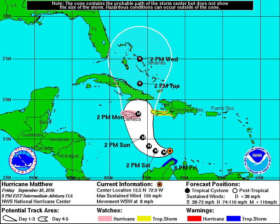
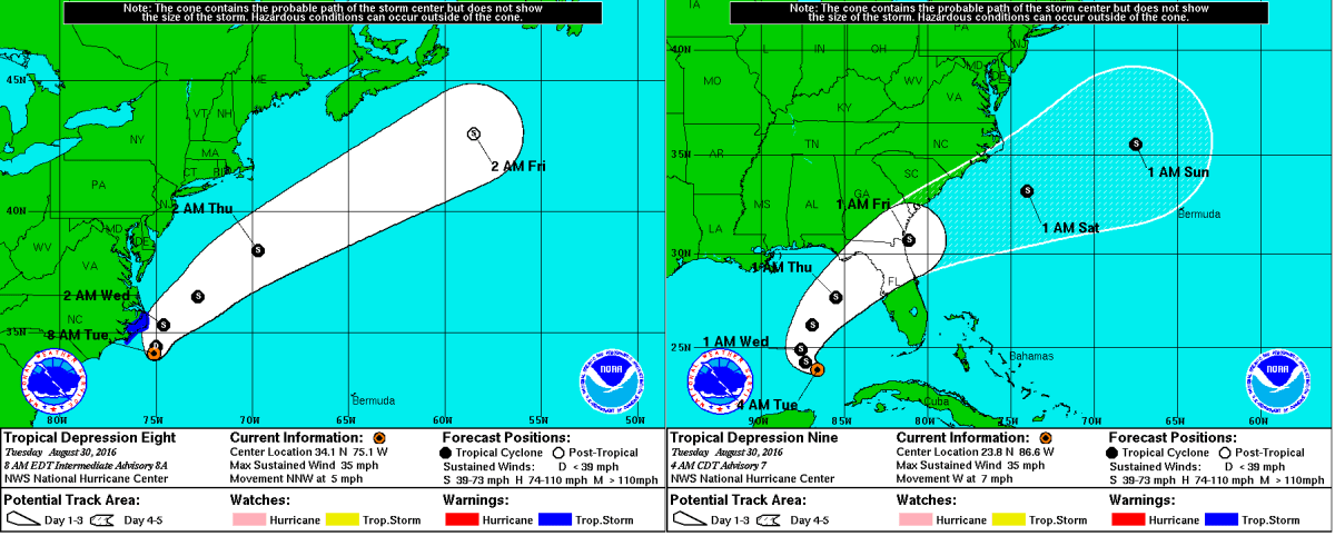
Invest 99L is an area of disturbed weather and thunderstorms currently moving west-northwestward at about 20 mph just east of the Leeward Islands. The storm has already defied some expectations that further organization would stall until the area of low pressure moved closer to Hispaniola, and has prompted an Air Force Reserve Hurricane Hunter aircraft trip into the storm later this morning. In the short term, a bit of a model consensus has been reached in terms of whether will the storm go north or south of Hispaniola, and over the past several days, more and more computer models have moved their tracks further to the north of the cyclone-killing mountains in Haiti and The Dominican Republic. The most likely storm track is as follows;  the storm will likely go north of Hispaniola and into the Bahamas before either being pulled north, or continuing on a track west over Florida (Sorry for the uncertainty, it’s still a bit early…) The most likely tracks do have one thing in common beyond the short term track though; most suggest landfall of at least a Tropical Depression somewhere on the East Coast of The United States. Whether the storm traverses Florida and makes another landfall somewhere in the Gulf before being pulled back into The Atlantic, or whether the storm moves up The East Coast, The United States will likely be impacted in some way, shape, or form by what is now Invest 99L.  It is important for those on The East Coast of The United States as well as those on the west coast of Florida to monitor the situation as it progresses and to stay tuned to updates from the National Hurricane Center.

Here's a look at The Tropical Atlantic Basin Satellite Imagery. 
Tropical Depression Fiona is north of The Leeward Islands, 
Invest 99L is east of the Leeward Islands,
And Tropical Storm Gastone is just west of The Cape Verde Islands.

More detail regarding Computer Model variations and outcomes can be found at our Hurricane Center page, where Weather360 is currently covering Invest 99L, Tropical Storm Gastone, as well as Tropical Depression Fiona in The Atlantic.