Potential for Significant Nor’easter Soon

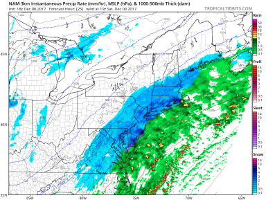
A low pressure system is forecasted to develop off the coast of Florida this Tuesday, at which point it has the possibility to come close enough to the coast to impact the Northeast by Thursday.

ECMWF Forecast 12 31 17
European Computer Model (ECMWF) run for Thursday, January 4, 2018, depicting a strong low pressure developing several hundred miles off the US East Coast. (Image courtesy of Weather.us)

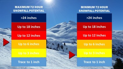
As low temperatures correlate to higher yields of snow from the same amount of liquid precipitation, should the storm system track any closer to the coast, upwards of half a foot to a foot of snow or more could be possible. At this time it is still unknown as to whether or not the storm will come close enough to impact the NYC area, but the potential exists for a significant winter storm or blizzard come later this week.

First Winter Storm of Season Expected Saturday

Winter Weather Advisories and Winter Storm Warnings are currently in effect for locations along the I-95 Corridor. While snow accumulations through Sunday morning will likely range from 3” to 6” across much of the NYC Metro Area, the possibility for greater snow totals does exist should the storm system shift to the west, as does the possibility for lower totals in the event that the storm shifts to the east.

NAM3km Rain Snow Forecast December 9 2017
The NAM 3km computer model run from Friday afternoon depicting heavier bands of snow developing across New England by 3 pm. Image from Tropicaltidbits

As the center of low pressure continues to develop, snow has begun to fall across portions of southern New Jersey and is expected to impact our area starting sometime in the mid-morning Saturday. While snow totals will likely remain below the 10” mark, expect moderate snow from around noon to 8 pm Saturday with the potential for some bands of heavier snow around the mid-afternoon. Most roadways will begin to see light accumulations of snow within one to two hours of the first flakes, meaning that all roadways will become slippery by the afternoon and evening.

Snow Accumulation 17-1.jpg
Weather 360 snow accumulation graphic for Saturday December 9, 2017. 3″-7″ can be expected across the NYC Metro Area.

Crippling Blizzard Expected Tuesday

Winter Storm and Blizzard Watches remain in effect for locations across the NYC area. Weather 360 is now forecasting that up to 2′ of snow is possible in locations situated mainly to the west and the north of the city, and that at least 6″ of snow will accumulate even in the event the storm does not make a “direct” hit.

Snow Accumulation 12
Weather 360 72 Hour Snow Totals Forecasts update about every 6 hours ahead of storms. Currently, Weather 360 is calling for at least 6″, and at most up to 2′.

It is increasingly likely that blizzard conditions will be felt on Tuesday, as heavy wet snow combined with wind gusts approaching 45+ mph may make for white out conditions. Due to the wind and snow, expect power to go out in some areas and take appropriate precautions ahead of the storm. For more information regarding the dangers this storm poses, consult the NWS at weather.gov. We’ll continue to keep you updated on the progress of this storm both here, and on our Facebook page.

Major Winter Storm Prompts Alerts in NYC Area

Winter Storm and Blizzard Watches are in effect for the entire NYC area. The National Weather Service is currently calling for up to 18″ of snow in some locations, as more major computer models have continued to suggest a strong Nor’easter developing off the East Coast by Tuesday morning.

GFS ECMWF 3 11 17 3 15 17 BLIZZARD
The GFS and the ECMWF (Euro) computer models from this morning. In the most recent runs, both models have suggested an essentially identical storm that will come in close proximity to the Mid Atlantic/New England coast, putting it in an ideal position to dump massive amounts of precipitation on the area.

Weather 360 is estimating that maximum snow totals in the area may exceed 18″ should the storm remain close enough to the coast to bring its moisture inland, but far enough away to keep temperatures below the freezing line. Even in the event that the storm does not remain in the Nor’easter ‘Goldilocks Zone’, expect there to be at least 3-6″ of snow on the ground by Wednesday morning. For more information regarding the dangers this storm poses, consult the NWS at weather.gov. We will continue to post updates on the progress of this storm over the coming days both here, and on our Facebook page.

Up to 8″ of Snow Possible Tomorrow; Major Storm Potential Next Week

Over half a foot of snow is possible tomorrow across large swaths of the Mid Atlantic and southern New England. Starting around midnight tonight, snow associated with an incoming weak low pressure system will move into the NYC area. Most of the snow should move out of the area by noon, but not before dumping an estimated 4-8 inches of snow.

HRRR computer model total snowfall accumulation by 4 pm ET 3/10/17.

Expect roads to be slick and potentially covered by a layer of snow and potentially some ice during the morning commute.

Going into Tuesday and Wednesday of next week, a potentially major Nor’easter may bring up to 2 feet of snow to New England and the Mid Atlantic. However, as this storm system is still not yet developed, it is difficult to forecast this with great accuracy, but recent trends have indicated that the potential for a major storm is increasing, and in the meantime, we’ll keep you informed.


Wintry Mess Expected Tomorrow

Only 2 days after the largest storm of the season, the Northeast is on the brink of yet another major winter weather event. In southern portions of the Mid-Atlantic and New England, snow in the morning will likely transition to a wintry mix or rain by the afternoon, but further to the north, cooler conditions will allow for up to 2 feet of snow to accumulate in some areas.

The most significant differences in snow accumulation are expected to occur between locations further to the south and closer to the coast, and those slightly further to the north and inland. In the NYC Metro Area, up to a foot of snow, sleet, as well as some ice is possible in locations to the north of Westchester, whereas in coastal NJ, NY, and CT, only a few inches of snow is expected before the transition to more liquidy precipitation takes place.

Regardless of accumulation, expect weather conditions tomorrow to reduce visibility and hamper travel all day. Please be aware of the weather conditions at your current location as well as in your destination if you intend to travel. More safety related information can be found at http://www.weather.gov.

Major Winter Storm Tomorrow

Winter Storm and Blizzard Warnings have been issued for the entire I-95 Corridor from New York to Boston. Exactly 4 years ago, Winter Storm Nemo created the exact same situation. Winter Storm Nemo, pictured below in an NOAA Surface Analysis, dumped 40 inches of snow in parts of Connecticut, and while tomorrow’s winter storm (named ‘Niko’) will likely dump no more than a foot and a half, it certainly is expected to resemble the historic storm that took place 4 years ago.

winter-storm-nemo-surface-analysis
Tomorrow marks the 4th anniversary of Winter Storm Nemo (above), and for the occasion, a nearly identical system is expected.

Expect high winds and heavy snow lasting from late tonight until tomorrow afternoon to greatly reduce visibility and knock down some tree limbs and power lines. Many schools across the area will likely be closed tomorrow, as the storm will also greatly reduce the ability to travel. Due to the remaining uncertainty in the storm’s intensity as it passes the area, Weather 360 is forecasting snow totals to vary from 6 inches in locations on the immediate coast, to as much as 16 inches for locations not much further inland.

 For information regarding watches, warnings, and advisories, visit weather.gov, and in the meantime, we’ll keep you posted.

Foot of Snow Possible Thursday

Over the past several days, more and more computer models have suggested that a ‘clipper’ snow storm would intensify just off the coast, dumping upwards of several inches of snow. Due to temperatures well-above average tomorrow, expect a small layer of ice on surfaces under all the snow Thursday, as some precipitation early on will fall as snow, melt, then freeze before it can accumulate.

nam_namer_054_sim_radar.gif
Above is the 6 UTC run of the NAM computer model displaying simulated radar for 7 am Thursday. Source: NOAA

Weather 360 is forecasting that a maximum of 12-18 inches of snow at this time in central portions of the Metro Area, with at least 3-6 inches of snow in locations further to the north, or at the freezing line at the immediate coast. The forecasted track and intensity of this storm are still fluctuating, so more information will be posted over the coming days. As always, please consult the NWS at weather.gov before making any decisions.


Major Snowstorm to Remain Offshore

A significant snowstorm expected to bring blizzard conditions and up to a foot of snow to portions of Virginia and the Southeast may bring up to several inches across the Mid Atlantic and the Northeast, prompting winter storm warnings and winter weather advisories for portions of Long Island and eastern Connecticut. The National Weather Service also forecasts light snow accumulation for much of the Metro Area, with areas of Long Island receiving as much as 6 to 8 inches of snow by tomorrow night.

Weather 360 forecasts up to 4 inches of snow for much of southwestern Connecticut, and a half foot or more of snow for much of Long Island. As the snow will start around midday, travel in the afternoon may become slick and at times there may be periods of low visibility.

Snow Accumulation 3.jpg

Please consult The National Weather Service at weather.gov for more info.

Snow Expected Tonight, May Cause Messy Morning Commute

A low pressure system currently located over the Southeast is on its way northeastward, and is expected to impact large swaths of the East Coast tonight into early tomorrow morning, prompting winter weather advisories for locations across southern Connecticut and New York, as well as in parts of New Jersey. Expect the snow to create slick conditions for the morning commute, as it will quickly stick to the ground and pavement.

Weather 360 is forecasting a maximum snow accumulation of about 3 inches in locations close to the coast, with a trace to an inch of snow further inland.

snow-accumulation-2