NHC ups the odds for tropical development in the Gulf

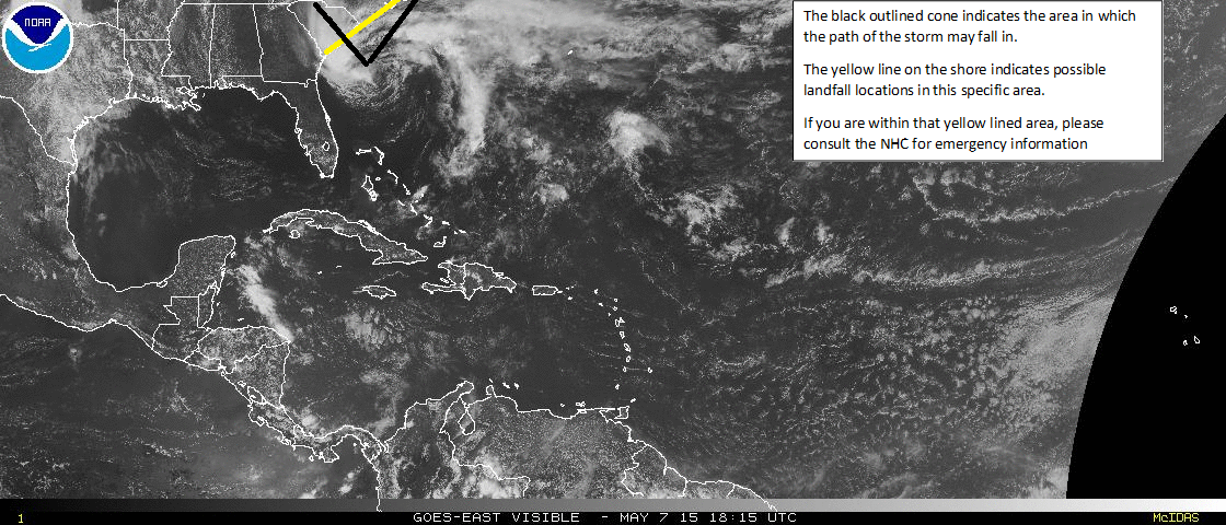
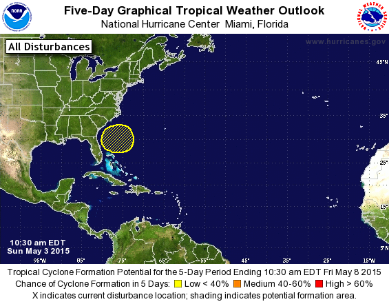
The NHC has increased the odds of tropical development in the Gulf of Mexico.  This morning, the odds for tropical entity development in the Gulf of Mexico according to the NHC has been raised to about 20% over the next five days.  This area of tropical disturbance is expected to cross the Yucatan Peninsula and drift into the central, western Gulf of Mexico, where it will have the opportunity to develop and strengthen (slightly), before moving over land somewhere on the United States Gulf of Mexico shore.

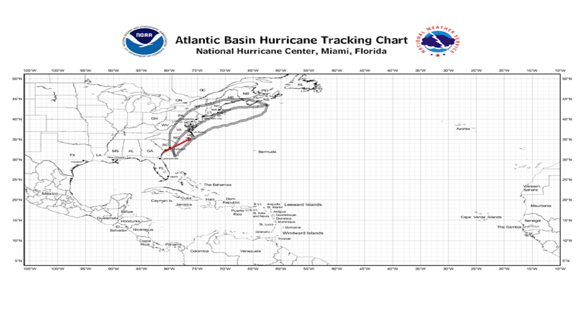
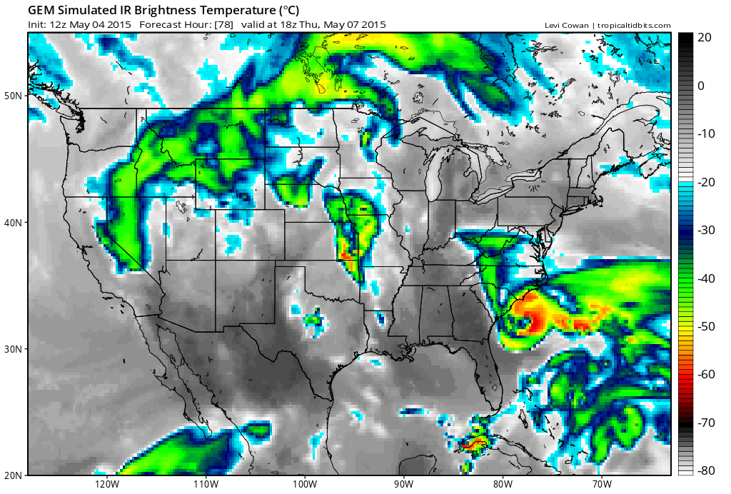
There are several different outcomes that may occur for this tropical disturbance.   Outcome one: The GFS computer model along with the ECMWF (The European computer model) are expecting this storm to stay as a weak tropical wave and only bring some moisture and wind to the Gulf Coast.                                                                                   Outcome two: This outcome, mainly promoted by the CMC computer model with some others, suggests that the disturbance will develop into a Tropical Depression or Tropical Storm before making landfall somewhere on the Gulf Coast (likely somewhere in between New Orleans and Brownsville (TX).

At the moment, tropical development is still not extremely likely, but we will keep an eye on this storm over the next several days.

Another disturbance forming in the Atlantic?

The National Hurricane Center (NHC) has created a watch area for a clump of thunderstorms beginning to develop a very weak low pressure.  The computer models have been suggesting that this clump of thunderstorms may develop and grow into some sort of tropical entity and bring some rain and wind to unknown portions of the western Gulf of Mexico Coast.

At the moment, we have not made an official prediction because the NHC is keeping this disturbance’s odds of development at 10%, although once this disturbance’s odds of development do come up, you can look for our official location and intensity forecast on our Hurricanes page.

NHC 5DAY CHART 6 12 15

This is the graphic set out to the public by the National Hurricane Center pertaining to today’s weather conditions across the Tropical Atlantic Basin.

We’ll keep you posted as more information on this disturbance arrives.

Slow start to the second full week of Hurricane Season 2015

As Hurricane Season 2015 approaches the two and a half week mark, there is still no tropical activity in the Atlantic Basin.  Besides Ana about a month ago now, there has been NO tropical disturbances in the Atlantic.

Why the slow start?

Well, in general, the peak of Hurricane Season is in early September, and if you look at your calendar right now, that is still about a whole 3 months away.  Anyways, June is normally not the most active month of any Hurricane Season, but from here on out to September, the probability of tropical development will be (on a historical average) increasing.  Not only this, but also at the moment there is no tropical enhancement wave (to put it more simply) over any portion of the Atlantic ocean.

That’s all for now, and we’ll keep you updated as Hurricane Season 2015 progresses!

Hurricane Season 2015 UPDATE, and the heat wave update for NYC

Officially at least, the 2015 Eastern Pacific Hurricane Season has started, but, unless a major storm (or at least the first significant disturbance) develops, there is not much to talk about in terms of tropical cyclones.  For the first time in a very long time, the Tropical Atlantic Basin has received its first tropical cyclone before the Eastern Pacific has.

Now for the update on the heat wave in New York City and the Tri-State Area…

With temperatures in the 80’s and humidity percentages close to 99%, the majority of those going outdoors will likely feel fairly hot and sweaty.  The heat index in some areas (how hot it actually feels) is in the 90’s.  For those who are sensitive to the extreme heat, please heed all advisories set out by the National Weather Service (NWS.)

Stay hydrated and be safe!

TROPICAL STORM ANA MAKES LANDFALL IN SOUTH/NORTH CAROLINA

The 50 MPH Tropical Storm Ana has just made landfall in South/North Carolina, bringing with it, rain, thunderstorms, and some storm surge.  Tropical Storm Ana is the first storm of the Atlantic Hurricane Season, and is also one of the earliest landfalls by a Tropical Cyclone on record. With Hurricane Season starting in over 20 days, some are now wondering how severe this upcoming season will be now… (this information can be found here at Weather 360.)

Where is Ana heading now?

083430W5_NL_sm(NHC prediction cone from earlier this morning.)

Where is Ana heading now?  Well, according to this NHC prediction cone, Ana is making landfall right now in South/North Carolina, (the border of), and will soon lose its Tropical Storm characteristics, but will remain as a Tropical Depression (Ana) with winds of about 30 MPH up until impacting southern New England and Long Island with some waves and some wind (and some rain.)

Weather 360 will keep you posted, stay safe!

Where’s soon-to-be Ana heading?

Have a look at our graphic, the red line on the coast means that imminent landfall is expected in the next two days.

Map of Ana 5 7 15 2019 PM EST UTC -4Map of Ana 5 7 15 2019 PM EST UTC -4

Our graphic shows Invest 90L, which will then likely be Ana, moving into the SC/NC coastline, but due to the current run of the European computer model, we are having this storm ride up the coast a bit further, then veering out to sea before having a chance to make landfall in New York and New England.

At the moment, the National Hurricane Center (NHC), is saying there is a 90% chance of development for this Invest 90L over the next 2 days.  Due to this storm being more associated with the Jet Stream, this storm will likely be first classified as a Sub-Tropical Storm, but don’t be fooled by the “Sub”, these storms are the equivalent of a regular Tropical Storm, and if they break free of whatever holds them back, can quickly strengthen.

For preparedness tips for this storm, consult the NHC or your local emergency management center to stay safe.

Stay safe and be prepared!

WATCH OUT! Tropical Storm Ana to form soon!

Over the next few hours, the very well defined and string tropical disturbance near the coast of the Carolinas may develop into a strong tropical storm.  With sustained winds already hitting 50 MPH and a very closed and well defined center of circulation, the NHC will have to begin issuing watches and warnings for the coastal areas of the Southeast (and even potentially the rest of the East Coast.)  This storm’s intensity will likely stay as a medium to strong Tropical Storm, and will likely track up through the edges of the Carolinas into the Atlantic Ocean near Long Island, before likely veering off to the east with the high pressures.

Have our look at the following graphic from Weather 360, the yellow means potential landfall locations from this storm.  We apologize for the clarity of the following image.

Untitled

IF YOU live on or near the coast of the Carolinas, please take IMMEDIATE ACTION according to the NHC and YOUR LOCAL EMERGENCY MANAGEMENT CENTER.  Please take all appropriate actions suggested by both your local center and the NHC to keep you and your property safe from the storm.

Be smart, and stay safe!

INVEST 90L FORMS NEAR FLORIDA, MODELS HAVE THIS HEADING NORTH

The computer models in a way have shifted overnight, instead of a track more into South Carolina, the majority of the computer models are suggesting that  this storm will likely impact northern parts of South Carolina, and mostly coastal areas in North Carolina.

What is this talk about Invest 90L heading northwards?

The computer models are beginning to suggest that Invest 90L has the potential to become a Tropical Storm before landfall, but also some of the models are also beginning to suggest that this storm could impact the Outer Banks, then move further northward as a weak Tropical Depression and merge with an incoming system to bring more rain to the Northeast United States.

Weather 360 urges anyone living on or near the coast in areas that may be impacted by this storm later on this week to at least think about potentially evacuating due to storm surge and flooding or having an emergency hurricane kit, which is shown in an example on the side of this page.  Please though, BEFORE you make any decisions, consult the NHC’s website, nhc.noaa.gov, to see what plan is best for you.

Tropical disturbance in the Atlantic could cause some serious problems to the East Coast

Have a look at the 12 UTC run of the CMC computer model.

potential tropical cyclone

What your seeing is the 12 UTC run from the CMC model, which, if you focus into the Southeastern Coast, you will see a simulated infrared image that depicts a well-developed cyclone with what appears to be an eye to the storm (meaning that this could be near/ at hurricane status soon.)

Due to this storm’s likelihood of being torn apart at the upper levels by a dip in the Jet Stream, it will likely originate as a Sub-Tropical system, with the potential to gain some tropical characteristics before its possible landfall there soon after.  Although the CMC model is predicting a strong system to appear, most of the computer models are keeping this likely at or slightly below Tropical Storm stage.  Still, at the moment, the forecasts are all over the place.

For anyone living on or near the Southeastern Coast, stay tuned to any possible announcements from the National Hurricane Center (NHC) regarding this system.  You can also visit our Hurricanes 360 page for a view at our highlighted areas that may be at risk, be we do stress to always consult with the NHC before doing anything.

Stay safe, and stay tuned.

THE NHC ISSUES FIRST WATCH AREA OF THE YEAR FOR WHAT COULD BECOME TROPICAL CYCLONE ANA

FIRST NHC GRAPHIC OF THE YEAR OF WHAT COULD BE ANA! The first NHC Tropical Watch area of the SEASON!

ITS OFFICIAL! This is now one of the earliest starts to the Atlantic Hurricane Season!  A tropical disturbance that we have been talking about for the past several days has now been highlighted by the National Hurricane Center in Miami, Florida.  As of now, Weather 360 will update our Hurricanes 360 page several times daily through November 30th of 2015.  This potential storm has the potential to strengthen into a hurricane and at the moment for a 5 day forecast by the NHC has a 30% chance of developing (which will likely significantly increase as next week approaches.)

Weather 360’s hurricane package will be free for a little while (at least the beginning of hurricane season) to show you the advance options we include in it.  The hurricane package (which we will rename for now) can be accessed by simply hovering your cursor over the Hurricanes 360 page and clicking on the dropped page below.

If you have not noticed about this storm, that although it has 30% odds of development, it is not classified as a medium chance, right?  Well, yes, since last hurricane season the NHC has changed their standards, meaning that now anything below 40% odds of development at the time of forecast initiation will be in the “low”, and therefore yellow shade.

Here’s a look on the NHC’s special statement on this disturbance

Tropical Weather Outlook Text

ZCZC MIATWOAT ALL
TTAA00 KNHC DDHHMM

SPECIAL TROPICAL WEATHER OUTLOOK
NWS NATIONAL HURRICANE CENTER MIAMI FL
1030 AM EDT SUN MAY 3 2015

For the North Atlantic...Caribbean Sea and the Gulf of Mexico:

1. A non-tropical area of low pressure is expected to form north of
the Bahamas later this week. This system could gradually acquire
some subtropical characteristics by Thursday or Friday as it moves
slowly northward. The next Special Tropical Weather Outlook will be
issued on this system by 11 AM EDT Monday.
* Formation chance through 48 hours...low...near 0 percent
* Formation chance through 5 days...low...30 percent

Forecaster Brennan

Stay safe, and lookout for a YouTube video to come out soon on this disturbance along with constant updates on Weather 360!