HEAT WAVE INCOMING FOR THE NORTHEAST!

Today in and around New York City, temperatures will be around 70 degrees with some rain, but next week, especially around midweek, a very intense heat wave is expected to arrive.

This heat wave will not only bring heat indexes in NYC to rise above 90, but across the East Coast temperatures will be above normal for this time of year with a very high humidity.  Temperatures in places such as D.C. could reach 90, and the heat indexes could soar into the triple digits.  Although this heat wave will strike next week, it is not expected to last very long, by the end of the week and the weekend, some rain will arrive in the NYC area to cool things off by several degrees.

Remember to stay hydrated!

BILL EXPECTED TO MOVE ACROSS MIDWEST TONIGHT AND TOMORROW WHILE A 7.0 MAGNITUDE EARTHQUAKE OCCURS IN THE SOUTH ATLANTIC

BREAKING NEWS: A 7.0 MAGNITUDE EARTHQUAKE HAS OCCURRED ON THE SOUTHERN MID ATLANTIC RIDGE, THERE IS NO TSUNAMI THREAT FOR ANY LOCATION SURROUNDING THIS AREA.

Tropical Depression Bill

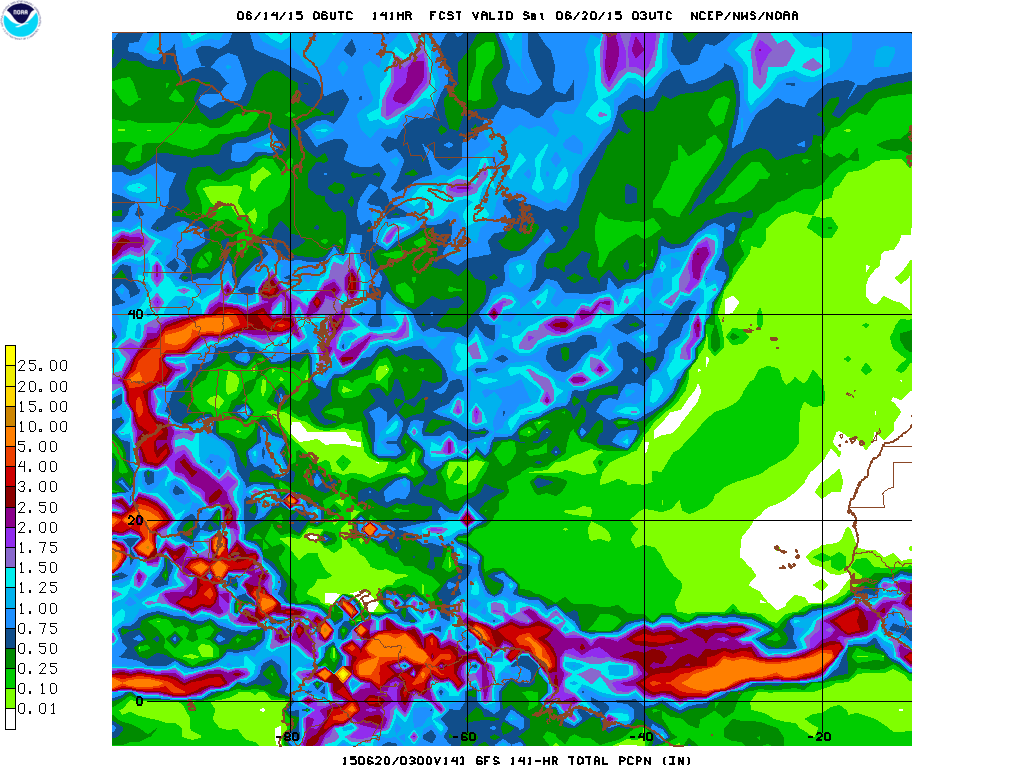
As Bill continues to swirl its way into Oklahoma, the rain bands extending into the Gulf of Mexico from its center are beginning to move northward as well.  The rain from this system is the biggest threat thus far for the remnants of Bill, with up to 8 inches of rain in southern Oklahoma, to several inches of rain expected to fall over a 500 mile long path across the United States over the next few days, to the possibility of severe thunderstorms, Bill has proved itself to be one large rain maker.

Okay, okay, we know that there will be large amounts of rain, but how will this affect me?  Well, as Bill dumps its remaining moisture over the US, already flooded rivers from just a few weeks ago that have not already returned to normal will pose a potentially catastrophic threat to anyone living on or near shorelines to rivers or streams. Also, in areas such as the Northeast, occasional downpours may cause flash flooding, which can take anyone by surprise.

Now that we have said how Bill may affect you, Weather 360 hopes that if you are to be impacted by any element of this storm, that you will be safe and heed all advisories, watches, and warnings set out by your local NWS (National Weather Service) office(s).

BILL WEAKENS TO TROPICAL DEPRESSION, NOW EXPECTED TO DUMP SEVERAL INCHES OF RAIN ACROSS THE MIDWEST

As Bill made landfall south of Galveston, Texas yesterday, it began its track to to Oklahoma.  Although Bill, now a Tropical Depression, has weakened, it is expected to stay organized as it is and even strengthen slightly before weakening while dumping the majority of its moisture on southeastern Oklahoma.  In areas such as northeastern Texas and eastern Oklahoma, rain amounts could range anywhere from 4 to 8 inches, potentially causing extreme flooding of streams, rivers, and low lying areas susceptible to inland flooding.  At the moment, Bill still remains fairly organized and is moving across Texas into Oklahoma, before significantly weakening to a remnant low and traversing the rest of the country until reaching the Northeast.  Once in the Northeast, the remnants of Bill will dump any last bit of moisture it has in the form of rain showers and the occasional thunderstorm.

Recently, rivers in the areas that are expected to see rain soon have flooded, some breaking historic records, this means that there is the possibility of large flooding to happen again with the heavy rains expected to come, so keep yourself safe by heeding all warnings set out by your local NWS (National Weather Service) office.

TROPICAL STORM BILL MAKES LANDFALL NEAR GALVESTON

This morning the NHC classified an area of disturbed weather with winds of 60 MPH with a well defined center of circulation as the second Tropical Storm of the year and the second Tropical Storm to make landfall this year in the United States, Tropical Storm Bill.  Currently, areas from the Louisiana border with Texas to the Mexican border near Brownsville are receiving some storm surge and winds in excess of 60 MPH along with torrential rains moving ashore.  The   NHC has issued Tropical Storm Warnings for the majority of the Texan eastern coast.  Several computer models are hinting (if not all of them) at the possibility of this storm maintaining at the very least Tropical Depression status several hundred miles inland, possibly to areas as far from the coast as Illinois or Indiana.  This storm is also bringing torrential rains to traverse the country as an abundance of tropical moisture comes through via Tropical Storm Bill. So, over the following days, rain will continue to spread over hard hit areas by flooding just about a week and a half ago, potentially bringing back severe flooding to areas susceptible to flooding.

For anyone in areas that are on the coast in Texas that will be impacted by Tropical Storm Bill, remain indoors unless absolutely necessary, and if you just go outdoors, exercise extreme caution and heed all warnings set out by the NHC.

Stay safe!

WATCH OUT TEXAS! SOON TO BE TROPICAL STORM BILL TO MAKE LANDFALL NEAR GALVESTON

Current Invest 91L (As of 7:00 PM EST June 15th 2015), is now expected to become Tropical Storm Bill later on this night before making landfall somewhere between Port Lavaca, Texas and Galveston, Texas.  This storm already has sustained winds of about 45 MPH and is quickly developing a more organized center of circulation.  This storm will dump anywhere between 2 and 8 inches of rain from the Texas coastline to Indiana and Ohio before losing all of its remaining moisture over land.  Current invest 91L will also likely maintain its strength for several hundred miles inland as a Tropical Storm with winds above 40 MPH and torrential rains until it reaches the Missouri border with Kansas. For anyone living on or near the coastline between Galveston and Port Lavaca, please consult the NHC or your local emergency management center, and for those who live near or on the shoreline of a river or stream that is prone to flooding, please keep yourself up-to-date with any advisories, watches, or even warnings that may come your way as a result of this storm system, and do not forget to finish up any emergency preparations before the storm hits you.

We will keep you up to date and for detailed information regarding the soon to be Tropical Storm Bill, consult first with the NHC, then come on over to our Hurricanes 360 page to see what we here at Weather 360 could do to help you ride out the storm.

Stay safe!

*We would also like to apologize for the mix up on our last post, Invest 91L is the storm in the Gulf of Mexico, Invest 90L was Tropical Storm Ana in early May before it developed.

SOON TO BE TROPICAL DEPRESSION TWO TO IMPACT THE TEXAS COASTLINE

INVEST 90L IS NOW EXPECTED TO MAKE LANDFALL AS A TROPICAL DEPRESSION OR TROPICAL STORM ON THE TEXAS COASTLINE.

In less than 3 days, current Invest 90L is expected to strengthen to a Tropical Depression or Storm and make landfall somewhere between Galveston, Texas, and the Louisiana border.  This storm is expected to not only bring some wind and some storm surge threats, but this storm will bring in enough moisture to cause intense rains and thunderstorms that may cause flooding.

Here’s a look at the GFS’s forecasted amount of  precipitation

GFS forecasted amount of rain for soon to be tropical depression two

As you can see, over the next 5 or so days, the moisture from the current Invest 90L will make its way through the central United States, before dumping the last of its rain on the majority of the Northeast and portions of Southeastern Canada.  Be on the lookout for heavy rains mid to late week next week in and around NYC.

For more information on Invest 90L, go to our Hurricanes page, and for emergency information for floods or tropical cyclone watches or warnings please refer to the National Hurricane Center (NHC) and weather.gov.

NHC ups the odds for tropical development in the Gulf

The NHC has increased the odds of tropical development in the Gulf of Mexico.  This morning, the odds for tropical entity development in the Gulf of Mexico according to the NHC has been raised to about 20% over the next five days.  This area of tropical disturbance is expected to cross the Yucatan Peninsula and drift into the central, western Gulf of Mexico, where it will have the opportunity to develop and strengthen (slightly), before moving over land somewhere on the United States Gulf of Mexico shore.

There are several different outcomes that may occur for this tropical disturbance.   Outcome one: The GFS computer model along with the ECMWF (The European computer model) are expecting this storm to stay as a weak tropical wave and only bring some moisture and wind to the Gulf Coast.                                                                                   Outcome two: This outcome, mainly promoted by the CMC computer model with some others, suggests that the disturbance will develop into a Tropical Depression or Tropical Storm before making landfall somewhere on the Gulf Coast (likely somewhere in between New Orleans and Brownsville (TX).

At the moment, tropical development is still not extremely likely, but we will keep an eye on this storm over the next several days.

Another disturbance forming in the Atlantic?

The National Hurricane Center (NHC) has created a watch area for a clump of thunderstorms beginning to develop a very weak low pressure.  The computer models have been suggesting that this clump of thunderstorms may develop and grow into some sort of tropical entity and bring some rain and wind to unknown portions of the western Gulf of Mexico Coast.

At the moment, we have not made an official prediction because the NHC is keeping this disturbance’s odds of development at 10%, although once this disturbance’s odds of development do come up, you can look for our official location and intensity forecast on our Hurricanes page.

NHC 5DAY CHART 6 12 15

This is the graphic set out to the public by the National Hurricane Center pertaining to today’s weather conditions across the Tropical Atlantic Basin.

We’ll keep you posted as more information on this disturbance arrives.

Slow start to the second full week of Hurricane Season 2015

As Hurricane Season 2015 approaches the two and a half week mark, there is still no tropical activity in the Atlantic Basin.  Besides Ana about a month ago now, there has been NO tropical disturbances in the Atlantic.

Why the slow start?

Well, in general, the peak of Hurricane Season is in early September, and if you look at your calendar right now, that is still about a whole 3 months away.  Anyways, June is normally not the most active month of any Hurricane Season, but from here on out to September, the probability of tropical development will be (on a historical average) increasing.  Not only this, but also at the moment there is no tropical enhancement wave (to put it more simply) over any portion of the Atlantic ocean.

That’s all for now, and we’ll keep you updated as Hurricane Season 2015 progresses!

The earliest landfall of a tropical cyclone on the Baja California in recorded history

Hurricane Blanca, now Tropical Storm Blanca, and soon to be Tropical Depression Blanca, has made landfall on the Baja California north of Cabo San Lucas with winds of about 50 miles an hour, which has created some rough surf and dangerous rip currents in an around the area.

Tropical Storm Blanca was only about 48 hours ago a massive category three, major hurricane, with winds over 130 miles an hour, but due to the lower water temperatures near the Baja California, the storm rapidly weakened and will continue this weakening trend until becoming a remnant low that will bring some moisture to portions of the lower US, and possibly could have a slight affect on the Northeast, but nothing terribly significant.

ALERT!

Areas in and around NYC have TORNADO WATCHES posted.  A TORNADO WATCH means that conditions over a large portion of land are more favorable than average for the development of tornadoes, please check with the National Weather Service (NWS) on weather.gov for specific watches and warnings that may affect you.