Tropical disturbance in the Atlantic could cause some serious problems to the East Coast

Have a look at the 12 UTC run of the CMC computer model.

potential tropical cyclone

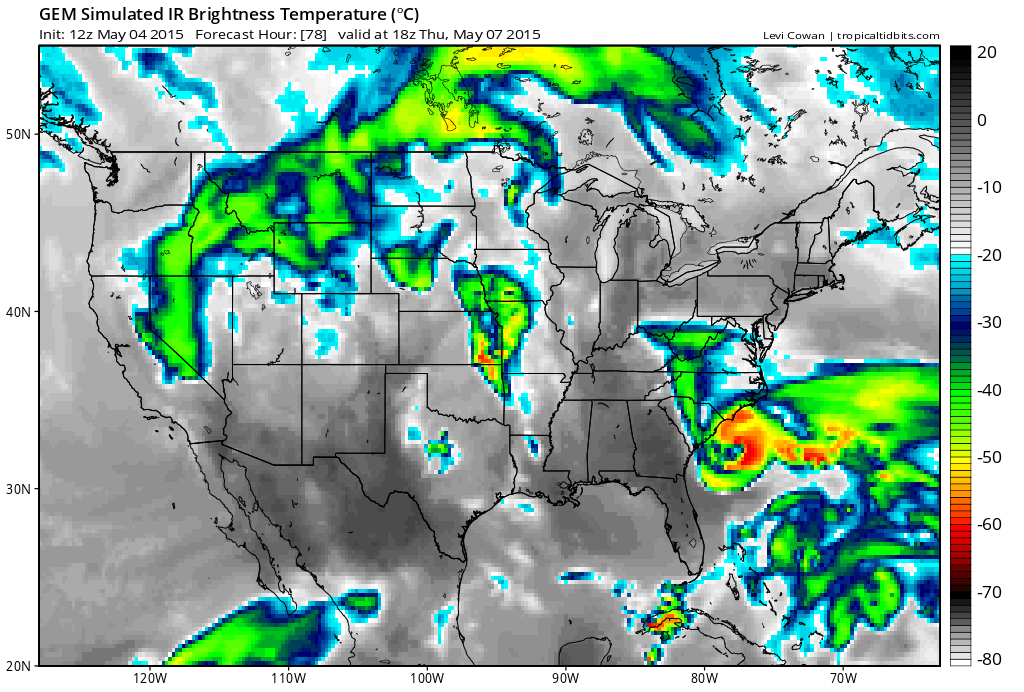
What your seeing is the 12 UTC run from the CMC model, which, if you focus into the Southeastern Coast, you will see a simulated infrared image that depicts a well-developed cyclone with what appears to be an eye to the storm (meaning that this could be near/ at hurricane status soon.)

Due to this storm’s likelihood of being torn apart at the upper levels by a dip in the Jet Stream, it will likely originate as a Sub-Tropical system, with the potential to gain some tropical characteristics before its possible landfall there soon after.  Although the CMC model is predicting a strong system to appear, most of the computer models are keeping this likely at or slightly below Tropical Storm stage.  Still, at the moment, the forecasts are all over the place.

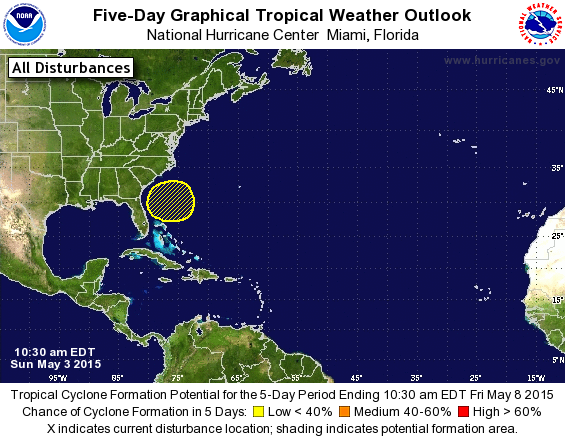
For anyone living on or near the Southeastern Coast, stay tuned to any possible announcements from the National Hurricane Center (NHC) regarding this system.  You can also visit our Hurricanes 360 page for a view at our highlighted areas that may be at risk, be we do stress to always consult with the NHC before doing anything.

Stay safe, and stay tuned.

THE NHC ISSUES FIRST WATCH AREA OF THE YEAR FOR WHAT COULD BECOME TROPICAL CYCLONE ANA

FIRST NHC GRAPHIC OF THE YEAR OF WHAT COULD BE ANA! The first NHC Tropical Watch area of the SEASON!

ITS OFFICIAL! This is now one of the earliest starts to the Atlantic Hurricane Season!  A tropical disturbance that we have been talking about for the past several days has now been highlighted by the National Hurricane Center in Miami, Florida.  As of now, Weather 360 will update our Hurricanes 360 page several times daily through November 30th of 2015.  This potential storm has the potential to strengthen into a hurricane and at the moment for a 5 day forecast by the NHC has a 30% chance of developing (which will likely significantly increase as next week approaches.)

Weather 360’s hurricane package will be free for a little while (at least the beginning of hurricane season) to show you the advance options we include in it.  The hurricane package (which we will rename for now) can be accessed by simply hovering your cursor over the Hurricanes 360 page and clicking on the dropped page below.

If you have not noticed about this storm, that although it has 30% odds of development, it is not classified as a medium chance, right?  Well, yes, since last hurricane season the NHC has changed their standards, meaning that now anything below 40% odds of development at the time of forecast initiation will be in the “low”, and therefore yellow shade.

Here’s a look on the NHC’s special statement on this disturbance

Tropical Weather Outlook Text

ZCZC MIATWOAT ALL
TTAA00 KNHC DDHHMM

SPECIAL TROPICAL WEATHER OUTLOOK
NWS NATIONAL HURRICANE CENTER MIAMI FL
1030 AM EDT SUN MAY 3 2015

For the North Atlantic...Caribbean Sea and the Gulf of Mexico:

1. A non-tropical area of low pressure is expected to form north of
the Bahamas later this week. This system could gradually acquire
some subtropical characteristics by Thursday or Friday as it moves
slowly northward. The next Special Tropical Weather Outlook will be
issued on this system by 11 AM EDT Monday.
* Formation chance through 48 hours...low...near 0 percent
* Formation chance through 5 days...low...30 percent

Forecaster Brennan

Stay safe, and lookout for a YouTube video to come out soon on this disturbance along with constant updates on Weather 360!

Potential tropical cyclone in the Atlantic, SOON!

Now with the support of several other major computer models, the ECMWF and the GFS computer models still suggest that some type of a tropical cyclone may occur near the eastern seaboard over the next few days.  This potential storm’s worst case scenario is being forecasted by a major computer model known as the CMC, which depicts a strong tropical storm or a category one hurricane impacting areas such as North Carolina with heavy rains, winds, and some storm surge.  Keep in mind, this is the current worst case scenario and is no more likely than there being a weaker storm off the coast, (again at the moment.)  Other computer models such as again the GFS, suggest a tropical cyclone, likely a tropical storm, off the eastern coast and veering out into the ocean in between the Carolinas and Bermuda.

For now, stay aware, and stay safe!

3…2…1 HAPPY HURRICANE SEASON, well in about 30 days…

Why the title one may ask?  Well, it’s because over the past several days the GFS and the ECMWF computer models have been hinting at the development of a tropical disturbance soon near the eastern coast of the United States.  (Also, this hurricane season, although expected to be below average, could potentially not be very happy for some…)

The potential storm does not look like, at the moment, to be a threat to the coastline, but since this storm has survived the changes of the computer models over the past several days, we will continue to update you when more significant developments occur.

For anyone who would like to know, this storm does not appear to be, again at the moment, to strengthen into a full fledged hurricane, but we will update you as the forecasts become clearer and clearer.

The Weather Channel releases another below average Hurricane Season 2015 forecast

This time around it is still the same, a below average Hurricane Season 2015…

The Weather Channel has just released their April Hurricane Season forecast calling for 9 named storms, 5 hurricanes, and only 1 major hurricane.  This, according to their article on their website about their newest forecast, implies that an El Nino, which normally inhibits Tropical Atlantic Basin cyclones, will have a large role to play in this year’s amount of tropical cyclones.

Weather 360 has been looking at the longer range forecasts, the April forecasts made by places such as Colorado State and TSR, and large factors already showing themselves in the Atlantic and Pacific, and we have been starting to see a growing potential for a less active Hurricane Season.

That’s all for now and we’ll keep you up to date on all of the latest developments on this Hurricane Season.

Thunderstorms are coming!

Over the next several hours thunderstorms will begin to develop in the New York City metro area.  Some of these storms could produce large hail and damaging winds,  so please if you are caught in a severe storm take cover immediately to avoid any injury.  Today there’s also the potential for flash flooding across all low lying areas and in areas near rivers or streams.  Later today there’s also the potential for gusty winds to cause some downed trees and power outages.  Be aware that at almost any time the National Weather Service may issue an advisory, a watch, or a warning.

Hurricane Season 2015

Although most of the major sources for forecasting the next hurricane season have been predicting a quiet, below average hurricane season, Weather 360 would like to remind everyone that it only takes one hurricane landfall to make a big difference across a wide area that could be anywhere on the Atlantic Basin coast from Maine to Texas.

Stay safe!

NCSU, the TSR, and Colorado state all forecasting a quiet Hurricane Season

According to all the sources’ listed above April forecasts, there will be a below average Hurricane Season in the Tropical Atlantic Basin.  The Tropical Storm Risk (TSR) program is predicting anywhere in between 8 and 15 total named storms, 3 to 9 hurricanes, and of which 1 to 4 would be major hurricanes.  What the TSR is predicting though is overall a 20% less active Hurricane Season than the historical long range average.

Here is what the overall highest percentage expectancy for all the sources mentioned (put together by Wikipedia)

TSR April 9, 2015 11 5 2
CSU April 9, 2015 7 3 1
NCSU April 13, 2015 4–6 1–3 1

An average Hurricane Season looks something more like this:

12 named storms, 6 hurricanes, and 3 major hurricanes.

So, you can see that there is some uncertainty in the exact number of storms there will be this Hurricane Season, but what all these programs are still urging is for anyone and everyone on or near the coast to be prepared for a possible hurricane strike, because it only takes one to create mass devastation.

Tropical cyclone in the Atlantic possible soon… BUT IN MAY?!!

For those who may not know, the Atlantic Hurricane Season begins June 1st and ends on November 30th.

Although this is only one computer model (GFS) and the latest possible hour run (384 hrs in advance), a possible tropical disturbance in one model still can, even if it is very far out, remind everyone that Hurricane Season is approaching.

Wait, what? The GFS model is predicting a tropical cyclone soon?

Well, at the moment since the time frame is extremely far our, this does not look likely, but the latest run of the GFS computer model for 384 hours is showing a small and weak disturbance near the Puerto Rico to the north.  DO NOT, WE REPEAT, DO NOT, TAKE THIS AS A 100% GUARANTEE, because at the moment, the odds of this are extremely low.  The point of this message though, is that Hurricane Season is literally around the corner, and that even outside of the Hurricane Season there still is the possibility for some tropical activity.

Weather 360 will keep you posted as more information comes out, but remember, at the moment, what the GFS computer model is showing has an extremely low chance of being anything significant.  Although, it still is never to early to prepare for Hurricane Season if you live on the coast.

More on Hurricane Season 2015

As said in the previous post, according to the first seasonal outlook by Colorado State on this year’s Hurricane Season, there will be a below average Hurricane Season.  Although this source has been very accurate in the past, DO NOT,  DO NOT, take this as the final predictions for the upcoming Hurricane Season.  There are still many other sources to release their forecasts and even more forecasts from the same sources to come out over the next couple of months.

Weather 360 is still thinking that this Hurricane Season will be closer to average due to the fact that the El Nino is not going to be very strong this year, meaning that Atlantic temperatures will be only slightly below average.

So, what we want to say to you in this post overall is that it is not a good idea to  take the first forecast all the way.

If you  live anywhere near or on the coast, now is the time to start being prepared.

Since there is not much in the way of severe weather on the way for the Northeast, all we have to say is to enjoy the warm temperatures! (But still, stay safe!)

Colorado State releases first official predictions for Atlantic Hurricane Season 2015!

Lets have a look at their first forecast (from Colorado State)

ATLANTIC BASIN SEASONAL HURRICANE FORECAST FOR 2015 Forecast Parameter and 1981-2010 Median (in parentheses) Issue Date 9 April 2015 Named Storms (NS) (12.0) 7 Named Storm Days (NSD) (60.1) 30 Hurricanes (H) (6.5) 3 Hurricane Days (HD) (21.3) 10 Major Hurricanes (MH) (2.0) 1 Major Hurricane Days (MHD) (3.9) 0.5 Accumulated Cyclone Energy (ACE) (92) 40 Net Tropical Cyclone Activity (NTC) (103%) 45

Basically that means that they expect a below-average Hurricane Season, with 7 named storms, 3 hurricanes, and 1 major hurricane.  Although Colorado State has been very accurate in the past, do not take the first official forecast as the final forecast, especially before all the other sources report their official forecast for Hurricane Season 2015 (NHC, NOAA, etc.)  The reason that Colorado may have set such a low expectation in terms of storms for this Hurricane Season may be due to the fact that there will be an El Nino, which normally hampers tropical development, but there is the possibility for some other enhancements to the season.

Even though at the moment the hurricane season, according to other sources will be around average, always be equally prepared for every Hurricane Season.  We will keep you posted as more information continues to arrive.

Start preparing for Hurricane Season if you live on or near the coast, and stay safe!

Enjoy the mild temperatures!