Elevated fire risk alerts today? Here’s why

Fire risk NOAA 4 15 15

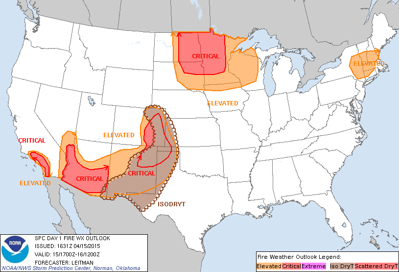
Image provided by the NOAA (Fire Weather Outlook for the next day)

Over the course of the last several hours, special weather statements (regarding fire danger) and red flag warnings have been being issued across the Northeast.  But first of all,  what does this mean?

Red flag warnings and special weather statements (regarding fire) normally mean that there is an elevated risk for wild or brush fire spread.

Okay, now that we know what that means, why is there a danger in the Northeast, who’s ever heard of a wildfire in the Northeast?

Well, due to low humidity and windy conditions, dry plants that may catch fire from a loose fire source (such as a match) will easily catch fire and quickly spread.  This makes even small, more easy to extinguish brush fires turn into larger, more violent fires fast.

So, please, even if you are not necessarily in one of the elevated risk areas shown above, exercise extra caution while dealing with a source of fire.

Have outdoor plans? It may be best to do them before the end of this upcoming weekend…

No, it is not what you are probably thinking, this time around the big threat will not be cool temperatures, but this time the only threat to outdoor plans is the rain that may come this weekend.

Although the weekend is still a few days away, the likelihood of there being a rain event across the Northeast has been steadily increasing as the GFS computer model and the European computer model (ECMWF) have both been suggesting that there may be a low pressure system that may sweep across the Northeast United States sometime later this weekend or very early next week.

Will there be a severe front to this storm system?

Yes, at the moment it does appear to look as if there may be a severe side to this system.  Right now, the severe side looks mainly to be in southern and western portions of the Northeast (this could very easily change.)

Although there is the possibility of a severe side to this storm, in most of the Northeast, it appears at the moment to likely only to be rain and some thunder.

Be on the lookout for any short term forecasts or hazardous weather outlooks by the NOAA to see if your specific area may be at risk.

Stay safe!

More on Hurricane Season 2015

As said in the previous post, according to the first seasonal outlook by Colorado State on this year’s Hurricane Season, there will be a below average Hurricane Season.  Although this source has been very accurate in the past, DO NOT,  DO NOT, take this as the final predictions for the upcoming Hurricane Season.  There are still many other sources to release their forecasts and even more forecasts from the same sources to come out over the next couple of months.

Weather 360 is still thinking that this Hurricane Season will be closer to average due to the fact that the El Nino is not going to be very strong this year, meaning that Atlantic temperatures will be only slightly below average.

So, what we want to say to you in this post overall is that it is not a good idea to  take the first forecast all the way.

If you  live anywhere near or on the coast, now is the time to start being prepared.

Since there is not much in the way of severe weather on the way for the Northeast, all we have to say is to enjoy the warm temperatures! (But still, stay safe!)

Colorado State releases first official predictions for Atlantic Hurricane Season 2015!

Lets have a look at their first forecast (from Colorado State)

ATLANTIC BASIN SEASONAL HURRICANE FORECAST FOR 2015 Forecast Parameter and 1981-2010 Median (in parentheses) Issue Date 9 April 2015 Named Storms (NS) (12.0) 7 Named Storm Days (NSD) (60.1) 30 Hurricanes (H) (6.5) 3 Hurricane Days (HD) (21.3) 10 Major Hurricanes (MH) (2.0) 1 Major Hurricane Days (MHD) (3.9) 0.5 Accumulated Cyclone Energy (ACE) (92) 40 Net Tropical Cyclone Activity (NTC) (103%) 45

Basically that means that they expect a below-average Hurricane Season, with 7 named storms, 3 hurricanes, and 1 major hurricane.  Although Colorado State has been very accurate in the past, do not take the first official forecast as the final forecast, especially before all the other sources report their official forecast for Hurricane Season 2015 (NHC, NOAA, etc.)  The reason that Colorado may have set such a low expectation in terms of storms for this Hurricane Season may be due to the fact that there will be an El Nino, which normally hampers tropical development, but there is the possibility for some other enhancements to the season.

Even though at the moment the hurricane season, according to other sources will be around average, always be equally prepared for every Hurricane Season.  We will keep you posted as more information continues to arrive.

Start preparing for Hurricane Season if you live on or near the coast, and stay safe!

Enjoy the mild temperatures!

Okay, you can come out now, spring temperatures are really here!

Spring is here!

For nearly all of New England and the Mid Atlantic, spring temperatures are here!

With temperatures in New York and Boston expected to soar into the upper 60’s and 70’s, spring must really be here to stay, right?

Well, at least for now, there is the possibility for a little cold dip in the next two weeks, but otherwise, spring temperatures will dominate.  Although this week will be somewhat soggy, spring temperatures will be around to make going outside at least in a way bearable…

For today and tomorrow though, spring is here, enjoy it while it lasts!

That’s really all for now with no large severe thunderstorm events expected over the next two days, so stay safe!

This weekend in the Northeast – ACTUAL SPRING CONDITIONS!

Across the Northeast, rain and thunderstorms will begin to move out into Canada and the Atlantic.  With the storms exiting, warmer temperatures and clear skies will be entering.  Across most of New England and nearly the whole Mid Atlantic, temperatures will be right near or even slightly above average.  According to the GFS model along with most of the short range models and the European model, skies will stay mostly clear due to a large high pressure being situated over the area.

That’s all for now, but enjoy the clear skies and drier conditions while they last!

Woke up early this morning? Blame the thunder…

This morning across the Northeast, thunderstorms have been disrupting the night.  Most of these thunderstorms may not even show up as thunderstorms on radar (but some do) because most of these storms only quickly flare up for a little while, creating enough thunder to disturb the night for many, but not being around or strong enough to be registered.  Even though temperatures in most of the Northeast are only slightly above freezing, thunderstorms are still occurring from Massachusetts to the Tri-State area.  That is also sometimes why there can be thunder snow in the winter, or as they call it in northern New England now, October through June…

If you have already heard about the tornadoes in the Mid West, we can assure you that although the likelihood for them in the Northeast is low, there is a slightly elevated chance in southern portions of the Northeast.

Stay safe!

Our very first YouTube video!

If you are having trouble viewing this video with clarity, please go onto our YouTube channel (Weather 360) and click on the video.

About our channel

Our YouTube channel is a new addition to the Weather 360 network.  On these videos will be regular updates, during the Hurricane and winter seasons on the weather in the Northeast and Atlantic Basin.

Today’s weather- stormy with a chance of baseball sized ice chunks and isolated tornadoes…

Weather 360 will no longer call our 7 PM (EST) post ‘The Latest’, instead, now we will bring in more information, especially about computer models, to all our posts, but will still save some more extra information for the 7 PM (This time is just an average for most of our evening posts) post.

Severe weather ahead?

Yes, although the title of this post is just a “bit” exaggerated, there is still the possibility of some (by some we mean a decent portion…) isolated tornadoes, and a higher chance of some (to use the NOAA’s words for severe thunderstorms just about everywhere severe storms could exist), large hail and damaging winds. Where (and when) will these potentially destructive storms occur?  The answer to that question is most places in the Northeast and today into tomorrow evening.  The most severe storms though will be situated in and around areas such as New York and Pennsylvania (that includes most other states surrounding the states mentioned.)  Live in Upstate New York or somewhere in the rest of northern New England?  You’ll be glad to hear that the severe threat will be further south, especially in the Mid Atlantic…

The Mid Atlantic and southern parts of New England have the greatest odds of receiving some of the severe storms making their way through the Mid West and parts of Pennsylvania and Maryland now.  Be on the lookout for any watches and warnings put out by the National Weather Service.

The severe storms moving through the Mid West now may produce some (a few inches maybe) of snow, but more on the icy side, in northern New England.

For those in northern New England, keep your shovels and ice scrapers nearby, and for those in the rest of New England and the Mid Atlantic, go inside if you hear thunder.

Stay safe!

There was snow last night? Wasn’t it just April yesterday?

There was snow last night?

It is true, the snow fell mainly in Maine, New Hampshire, Vermont, and Upstate New York last night due to the falling precipitation mixing in with the cold, below freezing air.  Who was our big winner last night in terms of snow you may ask?  KNOX COUNTY MAINE!  You are our big winner!  You received a whole fresh 6.7 inches of snow according to the National Weather Service!

Now that the celebrating is done…

We would like to move on to our next big weather event, the rain tonight in most of the Northeast, but even more wintry mess for you Maine, Vermont, New Hampshire, and Upstate New York!  Yes it is true, now let us show them what they have won again!  About a tenth or two tenths of an inch of ice is expected across the areas mentioned along with some more sleet and snow!

Okay, what about the rain?

In most of New England that isn’t cold enough and nearly the whole Mid Atlantic, precipitation will start to fall later today into tonight in the form of rain if it has not already begun, be careful, turn around don’t drown, meaning, DON’T DRIVE THROUGH FLOODED ROADS! (It isn’t a good idea…)

Also, be on the lookout for the potential of some severe weather affecting parts of New England the Mid Atlantic tonight into tomorrow.

Stay safe!  And really, don’t drive through flooded roadways.