Warm temperatures and red flag warnings

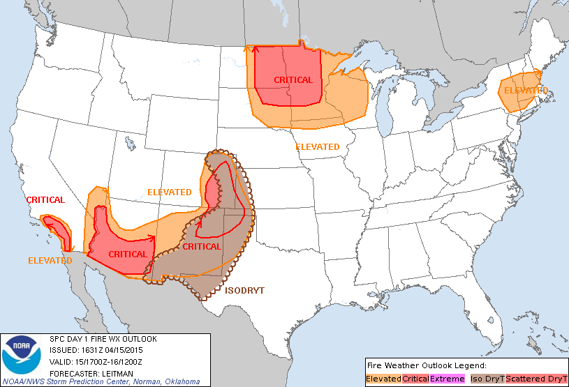
Across the Northeast, the National Weather Service (NWS) has had to issue red flag warnings and hazardous weather outlooks due to the very dry (and warmer than average) conditions later on today creating the conditions that spread wild and brush fires due to any type of ignition.  So, although today will be a very warm day, the NWS does not recommend anyone in the areas with red flag warnings or any type of advisory or alert to use matches or any type of ignition source outdoors due to risk of fire spread.  So please refer to weather.gov to see if your area is at risk today.

So, enjoy the above average temperatures today, but be aware that there is an elevated risk for the spread of fire today.

Warm temperature invasion tomorrow!

For anyone who has been waiting for temperatures warmer than 70 degrees, tomorrow you’ll be glad.

Tomorrow across southern portions of the Northeast, temperatures could reach as high as 75 degrees.   Some of these areas include the following; New Jersey, All of Pennsylvania except very northwestern portions, The NYC Metro Area, and other parts of southern  New England.

For locations in the northern parts of the Northeast, temperatures will likely be at or above 50 degrees, warmer in areas in central portions of the Northeast though.

Although we would like to keep going on about the warmer, early summer-like temperatures, we would like to bring up that there is the possibility for a large rain event across the Northeast early on next week.  Also, if anyone wants to know, the warm temperatures will go away after that storm…

We’ll keep you updated, and stay safe!

Elevated fire risk alerts today? Here’s why

Fire risk NOAA 4 15 15

Image provided by the NOAA (Fire Weather Outlook for the next day)

Over the course of the last several hours, special weather statements (regarding fire danger) and red flag warnings have been being issued across the Northeast.  But first of all,  what does this mean?

Red flag warnings and special weather statements (regarding fire) normally mean that there is an elevated risk for wild or brush fire spread.

Okay, now that we know what that means, why is there a danger in the Northeast, who’s ever heard of a wildfire in the Northeast?

Well, due to low humidity and windy conditions, dry plants that may catch fire from a loose fire source (such as a match) will easily catch fire and quickly spread.  This makes even small, more easy to extinguish brush fires turn into larger, more violent fires fast.

So, please, even if you are not necessarily in one of the elevated risk areas shown above, exercise extra caution while dealing with a source of fire.

More on Hurricane Season 2015

As said in the previous post, according to the first seasonal outlook by Colorado State on this year’s Hurricane Season, there will be a below average Hurricane Season.  Although this source has been very accurate in the past, DO NOT,  DO NOT, take this as the final predictions for the upcoming Hurricane Season.  There are still many other sources to release their forecasts and even more forecasts from the same sources to come out over the next couple of months.

Weather 360 is still thinking that this Hurricane Season will be closer to average due to the fact that the El Nino is not going to be very strong this year, meaning that Atlantic temperatures will be only slightly below average.

So, what we want to say to you in this post overall is that it is not a good idea to  take the first forecast all the way.

If you  live anywhere near or on the coast, now is the time to start being prepared.

Since there is not much in the way of severe weather on the way for the Northeast, all we have to say is to enjoy the warm temperatures! (But still, stay safe!)

Okay, you can come out now, spring temperatures are really here!

Spring is here!

For nearly all of New England and the Mid Atlantic, spring temperatures are here!

With temperatures in New York and Boston expected to soar into the upper 60’s and 70’s, spring must really be here to stay, right?

Well, at least for now, there is the possibility for a little cold dip in the next two weeks, but otherwise, spring temperatures will dominate.  Although this week will be somewhat soggy, spring temperatures will be around to make going outside at least in a way bearable…

For today and tomorrow though, spring is here, enjoy it while it lasts!

That’s really all for now with no large severe thunderstorm events expected over the next two days, so stay safe!

There was snow last night? Wasn’t it just April yesterday?

There was snow last night?

It is true, the snow fell mainly in Maine, New Hampshire, Vermont, and Upstate New York last night due to the falling precipitation mixing in with the cold, below freezing air.  Who was our big winner last night in terms of snow you may ask?  KNOX COUNTY MAINE!  You are our big winner!  You received a whole fresh 6.7 inches of snow according to the National Weather Service!

Now that the celebrating is done…

We would like to move on to our next big weather event, the rain tonight in most of the Northeast, but even more wintry mess for you Maine, Vermont, New Hampshire, and Upstate New York!  Yes it is true, now let us show them what they have won again!  About a tenth or two tenths of an inch of ice is expected across the areas mentioned along with some more sleet and snow!

Okay, what about the rain?

In most of New England that isn’t cold enough and nearly the whole Mid Atlantic, precipitation will start to fall later today into tonight in the form of rain if it has not already begun, be careful, turn around don’t drown, meaning, DON’T DRIVE THROUGH FLOODED ROADS! (It isn’t a good idea…)

Also, be on the lookout for the potential of some severe weather affecting parts of New England the Mid Atlantic tonight into tomorrow.

Stay safe!  And really, don’t drive through flooded roadways.

BEWARE! APRIL IS NOW CONSIDERED A MONTH CAPABLE OF PRODUCING WINTRY CONDITIONS!

BEWARE~ APRIL IS CAPABLE OF PRODUCING WINTRY CONDITIONS IN THE NORTHEAST UNITED STATES!

Well, can the Northeast ever catch a break?  One moment, winter is wrapping up, the next, seemingly starting back up again!

Tonight and tomorrow morning there is the possibility that cold temperatures in New England could create the conditions that create wintry weather.  Tonight in areas of southern parts of New England, sleet will mix in with rain, creating hazardous driving conditions for the morning commute, especially on I 95 in between Boston and New York. For northern parts of New England, sleet will mix in with freezing rain along with some snow tonight into tomorrow morning, also, creating some more hazardous driving conditions.

Be aware that some roads may also have a layer of black ice on them.  Stay safe!

Summer temperatures are on their way!

Summer temperatures are on their way!  But much like the very early spring, it is only a tease…

According to the European and the GFS computer models, in about a week and a half to two weeks there will be a sudden lift in the Arctic Jet Stream (the one that brings down all the cold Canadian air) and warm temperatures will flood even locations in Maine.  In southern parts of New England and the Mid Atlantic temperatures could soar past the 70 degree line.  Again though, just like earlier this season, the cooler temperatures will take back the Northeast and bring more March-like temperatures back.

Until then, be aware o the possibility of some thunderstorms today through Friday, and above all, stay safe!

Special: Weather 360’s analysis of the rest of spring outlook from the NOAA

The NOAA’s spring outlook discussion may seem a bit complicated, so in this post, Weather 360 will break down the main points of the discussion to tell you what spring 2015 will turn into for the Northeast.

Temperatures in the Northeast

The outlook basically says that slightly above to around average temperatures will be predominant in the Northeast.  The discussion along with other sources from the NOAA imply that the warmer to near average temperatures may enhance the risk, likely not by much, of there being more storms (some severe) in the Northeast later this season.

Precipitation

For the Northeast, the amount of precipitation this spring will be very close if not at average this spring.  Although temperatures will be close to average, flooding will be at an enhanced risk this season in northeastern parts of New England, where the snow pack is still melting.  Be aware this month of some flooding in northern locations in New England.

Stay safe, and enjoy the season while it lasts!

Is today the last day of mild, spring like temperatures for the week?

So, is today the last day of mild temperatures this week?

Unfortunately for at least New England, this may be true…

Temperatures in most of New England and New York have been relatively nice for spring so far, but it is still only early April, one of the most erratic times (temperature wise) of the year.  So for those in New England, have your sweatshirts ready, it is going to be a cool spring week.

But, for the Mid Atlantic, people can look forward to a week of temperatures on the milder side.

Yes, this is mostly what is going to happen in locations such as New Jersey and parts of Pennsylvania.  So, for people there, enjoy the weather!  Before the rain comes to spoil it…